مقدمة إلى التحليل الجغرافي المكاني للأعمال


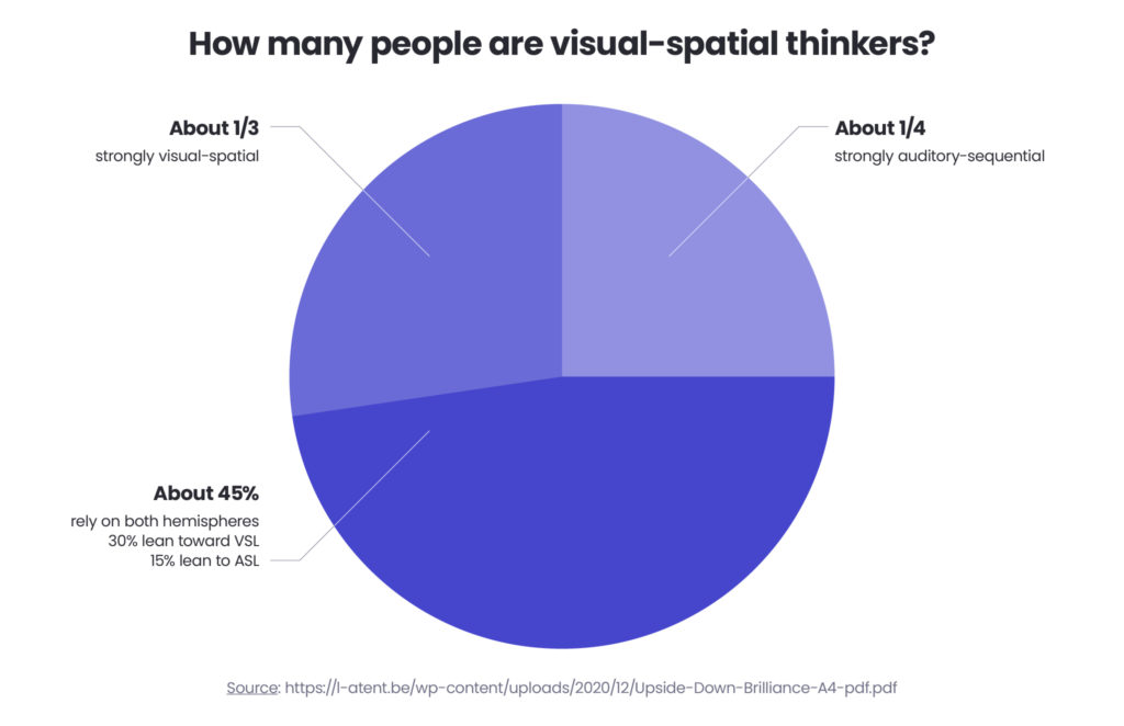
Imagine that you have to get somewhere or explore an unfamiliar area, and instead of a map, you have to follow numeric directions collected in columns and rows – it doesn’t sound too appealing, does it? As humans, a species that has been travelling from day one, we are naturally wired to think visually, in spatial models rather in numbers – the research by psychologist, Linda Kreger Silverman shows that over 70% من الأشخاص هم مفكرون بصريون ومكانيون.
It’s clear that numbers themselves have never been enough for humans and that’s where Geospatial Analysis comes in. The term itself was coined in the 1960s by a group of Canadian scientists who were documenting the country’s natural resources but has expanded and changed since then, especially with the modern technology available. Right from the start, it was built to echo human perception and its natural way of modelling. Geo-referenced data has become a crucial component, enhancing the understanding of complex relationships between people and locations. That’s how and when نظام المعلومات الجغرافية (GIS) تم إنشاؤه.
In this article – prepared in collaboration with Spyrosoft’s Principal Data Software Engineer, Michal Lupa, we’ll analyse the current state of Geospatial Analysis, explain what it means now and define how it can help businesses make better decisions and see things from a broader perspective. بيانات الموقع تلعب دورًا حاسمًا في التحليل الجغرافي المكاني، مما يمكّن الشركات من تحسين مواقع المتاجر، وتحسين الخدمات اللوجستية، وتعزيز ذكاء الأعمال.
ما هو التحليل الجغرافي المكاني
Geospatial Analysis is a type of analysis that allows the exploration and discovery of dependencies and common points between the objects within our modelled environment in geographical space. The components of the geospatial analysis are used to provide information on the distance between two objects, the shortest route between them, the condition of the area we monitor, the land relief and elevation of the terrain. By collecting and analysing this data, you can then use it to create a 2D or 3D model of a certain area.
Geospatial Analysis supports the decision-making process in business and in public infrastructure, i.e. to check how ambulances move through a city and if they can reach any area within a designated emergency response time – see below for more use cases.
تحليل المسافة والاتجاه
A distance and directional analysis focuses on estimating a distance between certain points and is used to calculate the time needed to go from one point to another, either by public transport or a bus. The analysis allows the creation of a temporal coverage map that can be displayed in a public transport/navigation application. This type of analysis is called network analysis and is based حول تقنيات الرسم البياني بما في ذلك على سبيل المثال A* أو خوارزمية ديكسترا.
اعرف المزيد في دليلنا للتحليل الجغرافي المكاني
اقرأ المزيد
ما فوائد استخدام تحليلات البيانات الجغرافية المكانية
يوفر تحليل البيانات الجغرافية المكانية مجموعة واسعة من الفوائد التي يمكن أن تعزز قدرات المؤسسة بشكل كبير:
زيادة الكفاءة
Geospatial data analytics enables organisations to optimise their operations, reduce costs, and improve productivity. For instance, locational analysis can streamline logistics and transportation routes, saving time and resources.
إدارة مخاطر معززة
By identifying areas of high risk through spatial analysis, companies can develop targeted strategies to mitigate those risks. This is particularly valuable in fields like disaster management and environmental conservation.
اتخاذ قرارات أكثر استنارة
When using Geospatial Analysis, you can see the change in your data in space and time which will – in the long run – help you make better-informed decisions. It’s important to mention here that when you deal with Geospatial Analysis, look at the datasets rather than single data points because that will give you a way to track the whole geographical unfolding of a certain event or occurrence.
تعزيز التحليلات لموظفيك وعملائك
As stated above, humans are visual-spatial thinkers, so why not use this principle when designing reports and analyses for your employees and customers? This will make them easier to read and understand.
تمكين التحول الأخضر
These geospatial datasets will serve as a starting point for larger projects – this is thanks to the fact that they can be integrated into different tools, including Business Intelligence and Sales Operations products. They can be handily used in any projects related to sustainability and the Green Transformation.
خدمة عملاء أفضل
Geospatial data analytics helps organisations understand their customers’ needs and preferences, allowing for more targeted marketing and improved customer service. For example, analysing spatial patterns of consumer behavior can inform retail location strategies and personalised marketing campaigns.
أكثر أدوات برمجيات التحليل الجغرافي المكاني شيوعاً
وفقًا لميخال لوبا، يمكن للشركات التي تتطلع إلى إدخال منتجات التحليلات الجغرافية المكانية في مشاريعها الآن استخدام عدد هائل منالبرمجيات أدوات، بما في ذلك:
GIS
Esri ArcGIS Desktop، ArcGIS Pro: مجموعة راسخة من الأدوات البرمجية من عائلة Esri المستخدمة في معالجة البيانات – بدءاً من قراءة البيانات والتحليلات المتقدمة وصولاً إلى إعداد قواعد البيانات وتقديم البيانات كـ خدمات ويب سهلة الاستخدام
QGIS (أداة نظم المعلومات الجغرافية مفتوحة المصدر): برنامج مفتوح المصدر يمكن استخدامه كبديل لـ Esri COTS.
الاستشعار عن بعد
ENVI، SNAP: يُستخدم في الاستشعار عن بعد ومعالجة بيانات الأقمار الصناعية.
استخراج وتحويل وتحميل البيانات المكانية (ETL):
FME – يُستخدم لبناء خطوط أنابيب ETL التي تتيح معالجة البيانات من مصادر مختلفة.
Geokettle – أداة ETL مكانية مدفوعة بالبيانات الوصفية تتيح لك دمج البيانات من مصادر مختلفة ثم استخدامها لبناء مستودعات وقواعد بيانات وخدمات للبيانات الجغرافية.
Talend – أداة ETL أخرى يمكنك استخدامها لتكامل البيانات. وهي توفر حلولًا برمجية منفصلة لإدارة البيانات وإعداد البيانات وكذلك لتكامل البيانات والتطبيقات.
مشاركة البيانات الجغرافية المكانية
خادم ArcGIS: a backend server component of ArcGIS Enterprise that enables sharing of geoinformation with any application or/and anyone with Internet access. It’s also used to build GIS Web services and platforms.
Geoserver: بديل مفتوح المصدر لـ ArcGIS Server.
Mapbox: تُستخدم لإنشاء خرائط جميلة يمكن بعد ذلك تضمينها في أي موقع ويب أو تطبيق.
قواعد البيانات المكانية
PostGIS (الامتداد المكاني لـ PostgreSQL): قاعدة بيانات جغرافية قوية تتيح معالجة البيانات.
Oracle Spatial: مكوّن من Oracle Database يُستخدم لإنشاء خرائط تفاعلية وإجراء تحليلات مكانية على بيانات الأعمال.
SpatiaLite: بديل لـ PostGIS وOracle Spatial وامتداد مكاني لـ SQLite يُستخدم لوظائف قواعد البيانات الجغرافية المتجهة.
لغات البرمجة
Python – GDAL، Geopandas، Rasterio: مكتبات Python التي تتيح معالجة البيانات الجغرافية المكانية.
Arcpy: حزمة موقع Python تتيح تحليلاً فعالاً للبيانات الجغرافية وتحويل البيانات وإدارتها.
OpenLayers: مكتبة JavaScript مفتوحة المصدر لعرض بيانات الخرائط في المتصفحات، مشابهة لـ Google Maps وBing Maps.
Esri JavaScript API: واجهة برمجة تطبيقات مفتوحة المصدر تتيح لك بناء تطبيقات ويب بتصورات ثنائية وثلاثية الأبعاد وخرائط تفاعلية.
تقنيات وأدوات التحليل الجغرافي المكاني
يمكن تقسيم التقنيات والأدوات الجغرافية المكانية إلى عدة فئات:
- أدوات معالجة البيانات المتجهية والنقطية
وتشمل هذه:
- المعالجة الهندسية،
- تحليل القرب،
- جبر الخرائط،
- التحليل الإحصائي الجغرافي،
- أدوات التصميم الخرائطي.
2. أدوات الاستشعار عن بعد التي تركز على معالجة صور الأقمار الصناعية أو الصور الملتقطة من الطائرات.
3. LiDAR – أدوات معالجة السحابة النقطية المستخدمة لإنشاء نماذج رقمية دقيقة للتضاريس.
4. نماذج الشبكات – رسوم بيانية مصممة لإجراء تحليلات المسافة والاتجاه، بما في ذلك على سبيل المثال مسارات الحافلات أو خطوط أنابيب الغاز أو تدفق المياه عبر نظام إمداد المياه.
حالات استخدام التحليل الجغرافي المكاني
Due to its flexibility and business value, geospatial analysis can be used in almost any industry and sector, with benefits to its employees, customers, and growth. Here’s a list of the most common use cases.
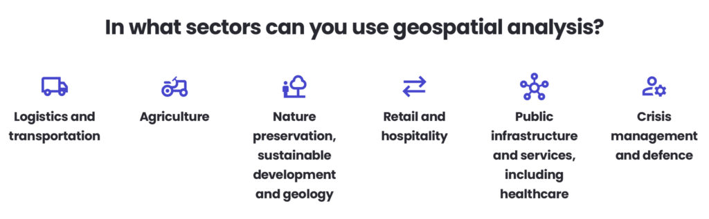
الخدمات اللوجستية والنقل
Logistics and transportation are one of the widely used functions of geospatial analytics, and the ones that touch almost every other industry. Not sure how to get somewhere by bus or car? You’d be likely using a tool where advanced geospatial analytics processes will be completed. Planning deliveries for your company and scheduling your production processes around those? You cannot get anywhere without geospatial analysis tools.
الزراعة
Agriculture is one of the sectors that has undergone a massive change over the past 5 – 10 years. While the general public may still see it as an idyllic area where little technology is needed nor used, this is not the case. On the contrary, modern farming entities employ a wide range of digital tools, including robots, AI-based solutions, and last but not least, geospatial analysis products that can easily scan fields for any disturbance to the quality of the crops.
الحفاظ على الطبيعة والتنمية المستدامة والجيولوجيا
You can use Geospatial Analysis to model where certain plants or mushrooms would grow, find heatmaps on the city plan, or analyse what minerals could be hidden in a particular rock exposure. Geospatial analysis was first used in this type of project, so it’s a common practice to involve it in any activity related to developing more sustainable environments for both businesses and individuals and those focusing on preserving and hopefully, replenishing any of Earth’s natural resources.
التجزئة والضيافة
يمكنك التحقق مما إذا كان افتتاح متجر أو مطعم أو فندق في منطقة معينة فكرة جيدة بمجرد رسم خرائط وتحليل كثافة منشآت قطاع الخدمات في تلك المنطقة.
البنية التحتية والخدمات العامة، بما في ذلك الرعاية الصحية
يمكنك التحقق مما إذا كان افتتاح مدرسة في منطقة معينة فكرة جيدة وما إذا كانت سيارة الإسعاف ستتمكن من الوصول إلى أحياء معينة.
إدارة الأزمات والدفاع
With the increasing number of natural disasters and occurrences related to the climate crisis, geospatial analysis can play a crucial role in not only managing these, but also as a powerful tool in predicting and preventing catastrophic events from happening.
الدور عليك
هل تحتاج إلى مساعدة في تطبيق حلول التحليل الجغرافي المكاني على أنشطة عملك؟ فريق الخدمات الجغرافية المكانية لدينا هنا للمساعدة – اطّلع على أحدث عروضنا وتواصل معنا.
الأسئلة الشائعة: التحليل الجغرافي المكاني
Geographic Information System (GIS) is a system designed to collect, store, manage, analyse, and visualise geographically referenced data. It was developed to help model real-world environments and understand the relationships between people, objects, and locations.
يتيح التحليل الجغرافي المكاني للمؤسسات:
– تحسين مواقع المتاجر
– تحسين اللوجستيات ومسارات التوصيل
– تحليل كثافة السوق وسلوك العملاء
– تخطيط استثمارات البنية التحتية
– مراقبة الأثر البيئي
من خلال تصور البيانات في المكان والزمان، تكتسب الشركات منظورًا أوسع ويمكنها اتخاذ قرارات أكثر استنارة قائمة على البيانات.
يُستخدم التحليل الجغرافي المكاني في العديد من القطاعات، بما في ذلك:
– اللوجستيات والنقل – تحسين المسارات وتخطيط التسليم
– الزراعة – مراقبة المحاصيل والزراعة الدقيقة
– الحفاظ على الطبيعة والجيولوجيا – النمذجة البيئية والتنقيب عن المعادن
– قطاع التجزئة والضيافة – الذكاء المكاني وتحليل السوق
– البنية التحتية العامة والرعاية الصحية – تخطيط الاستجابة للطوارئ وتحليل إمكانية الوصول
– إدارة الأزمات والدفاع – الاستجابة للكوارث والنمذجة التنبؤية للمخاطر
By analysing environmental patterns, energy usage, land development, and transportation networks, organisations can make data-driven decisions that reduce environmental impact and support long-term sustainability goals.
لا. في حين تقود المؤسسات الكبيرة غالبًا عملية التبني، فإن الأدوات مفتوحة المصدر الحديثة والمنصات السحابية تجعل التحليلات الجغرافية المكانية متاحة أيضًا للشركات الصغيرة والمتوسطة الحجم.


arrow_circle_rightاتصل بنا