جمع بيانات الأقمار الصناعية معاً – ببساطة وذكاء وللجميع


Satellite data has become one of the most powerful tools in our efforts to understand and manage our rapidly changing planet. Earth Observation satellites provide a continuous, real-time record of the world around us. However, while the volume and value of this data continues to grow, so too do the barriers preventing its full utilisation.
For many professionals in various sectors, EO data remains frustratingly out of reach. It is scattered across platforms, hidden behind technical barriers or locked away in formats that require specialist knowledge to interpret. Despite the clear demand for spatial insights, the majority of EO data today remains unused. This is the challenge being addressed by a new generation of tools that transform how we access, analyse and act on satellite data.
في كلمتنا الأخيرة في GeoBusiness 2025, we explored how EO DataHub and tools such as EOPro are transforming satellite data into a truly inclusive resource that is simple, smart, and poised to make a real impact. In this article, we’d like to introduce these tools in more detail, explore how they are bridging the gap between complex satellite datasets and everyday decision-making, and share the opportunities they create for industries, communities, and the planet.
بيانات الأقمار الصناعية المجزأة وصعبة الاستخدام
With our planet under pressure, up-to-date information is essential. Earth Observation (EO) data, gathered daily by satellites orbiting above us, provides a valuable means of understanding and responding to these changes. It captures everything from shrinking glaciers to the expansion of urban areas and generates over 150 تيرابايت من البيانات الجديدة يومياً.
على الرغم من الإمكانات الهائلة لهذه البيانات، كما ينعكس في التوقعات التي تُقدّر سوق بيانات رصد الأرض بـ12 مليار دولار بحلول 2031، يبقى الكثير منه غير مستخدم. في الواقع، حتى 80% of EO data goes unused, largely due to hurdles such as limited access, a shortage of technical expertise, and the daunting complexity of data formats and platforms. These challenges hinder government agencies, educators, NGOs, businesses and researchers, all of whom could benefit from these insights.
اكتشف كيف نستفيد من بيانات الأقمار الصناعية!
اكتشف المزيد
EO DataHub – غرفة محركات رؤى EO
Launched in 2023 as part of the UK’s Pathfinder programme, the EO DataHub is the result of a national effort to simplify and increase the use of Earth observation data. With backing from nearly £10 million in funding and developed through a coalition of public institutions and private sector partners, the platform was designed to act as a ‘Grand Central Station’ for satellite data – providing a single point of access to public and commercial EO resources across the UK.
EO DataHub goes far beyond data aggregation. It provides a unified, cloud-native environment in which users can find, process and analyse EO data, eliminating the need to switch between tools or platforms. Ready-to-run analytical workflows, such as land cover classification and water quality indexing, enable users to swiftly transform raw data into meaningful insights. The system supports a wide range of user profiles, offering intuitive, no-code tools for beginners and full API-level access for advanced users and developers.
صُمم EO DataHub للأداء في الوقت الفعلي ومبني على معايير مفتوحة، وهو يمكّن بالفعل تطبيقات مؤثرة، مثل:
- EOPro، بيئة مرئية بدون برمجة لاستكشاف وتحليل بيانات رصد الأرض (EO) الموجه
- CLARAT هي أداة تحقق من صحة البيانات الجوية تم تطويرها بالتعاون مع علماء المناخ.
تعرّف على EOPro وشاهد كيف يحوّل البيانات إلى إجراءات
As we mentioned at the beginning, the problem with Earth Observation data is not that it is scarce, but that it is fragmented and complex, and that there are technical barriers preventing most users from accessing its full potential.
في Spyrosoft، طورنا EOPro بالشراكة مع برنامج تطبيقات الأقمار الصناعية لمعالجة هذه التحديات. وبصفته بوابة قائمة على الويب بدون برمجة ومتكاملة بسلاسة مع EO DataHub، يعيد EOPro تصور الطريقة التي يتفاعل بها الناس مع بيانات الأقمار الصناعية.
توفر EOPro منصة موحدة وبديهية يمكن للمستخدمين، بغض النظر عن خلفيتهم التقنية، من خلالها الوصول إلى بيانات رصد الأرض وتحليلها وتصورها بسهولة.
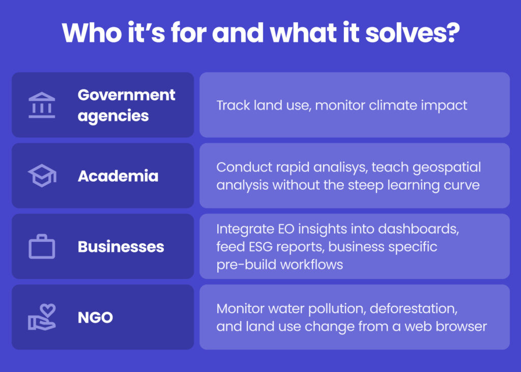
At the heart of EOPro lies a visual tool that empowers users to build custom geospatial workflows by arranging analysis steps within a simple drag-and-drop interface. Whether the task involves generating land cover maps, monitoring water quality or tracking environmental changes over time, EOPro enables users to transform raw data into actionable insights with just a few clicks. The platform supports both predefined workflows for common scenarios and the flexibility to design bespoke analyses, making it valuable and accessible for government agencies, academics, businesses and NGOs alike.
من زر سهل إلى قوة جبارة – ما التالي؟
EOPro and EO DataHub are continuing to evolve. Upcoming developments include flexible access tiers, integration with commercial and third-party datasets, AI-enhanced workflows and support for user-provided data, like in-situ measurements.
الخاتمة
GEO Business 2025 served as a reminder that the geospatial field is shifting from an era of data abundance to one of data empowerment. The tools we develop should facilitate actionable insights, not merely information access. At Spyrosoft, we see our role as facilitating this change by helping organisations use EO data to plan more sustainably, respond more quickly and innovate more intelligently.
So, if you’re looking to take your data analysis to the next level, our experts are here to help. Contact our team to find out how we can support your organisation in making the most of satellite data.
فالأرض في النهاية تخاطبنا عبر كل إشارة ونمط وتغيّر. والآن جاء دورنا للاستماع.
The biggest challenges are the fragmentation of data across multiple platforms, the technical complexity of formats and tools, limited accessibility due to costs or licensing, and the overwhelming volume of information, much of which remains unused.
EO DataHub is a unified platform developed under the UK’s Pathfinder programme that brings together public and commercial satellite data. It simplifies access, enables users to search and analyse data in one place, and offers ready-to-use workflows as well as APIs, making Earth Observation data easier to use for both beginners and advanced users.
EOPro is a no-code, web-based portal that works with EO DataHub, designed to let users visualise and analyse satellite data without technical expertise. It features drag-and-drop workflows and predefined tools, making it accessible to government agencies, researchers, NGOs, businesses, and anyone who needs spatial insights.
Future plans include flexible access tiers, integration with more commercial datasets, AI-driven workflows, and the ability for users to incorporate their own data, all aimed at improving usability and broadening the impact of satellite data.


arrow_circle_rightاتصل بنا
لنتواصل للتحقق من كيفية دعم خبرائنا لمشروعك

arrow_circle_right مدونتنا