الابتكارات التقنية في حلول البرمجيات الجغرافية المكانية وتأثيرها على النمو السريع للصناعة


In recent years, the geospatial field has witnessed immense growth, fuelled by richer and more precise data and cutting-edge advancements in the digital realm. Constantly emerging technological novelties are continuously contributing to the creation of better-performing and more accessible geospatial software solutions. Consequently, the sector has also begun to play a greater role in developing and supporting other industries.
في هذه المقالة، نستند إلى خبرة خبرائنا – Jaroslaw Marciniak (مديرالخدمات الجغرافية المكانية) and Andrew Radcliffe (Managing Director of Spyrosoft UK), to address the topic of software engineering and technology in the geospatial industry and discover what opportunities they can bring to different companies.
نظرة على صناعة البيانات الجغرافية المكانية
Globally, the geospatial industry is growing rapidly. Lately, it has been shifting away from a product-centric approach and focusing on being solutions-oriented with a strong emphasis on IT technologies and engineering. Moreover, advanced geospatial analytics has become integral to various sectors such as archaeology, disaster response, urban planning, infrastructure, logistics, transport and retail.
وبأخذ ذلك في الاعتبار، فإن التنبؤ الوارد في تقرير GEOBUIZ 2022 that the global geospatial market will reach a staggering USD 681 billion by 2025 should come as no surprise. The current growth of the sector is primarily driven by physical technology innovation. With a 45% market share, GNSS & Positioning hardware is predicted to be the most popular and fastest-growing geospatial tech category. It is followed by GIS & Spatial Analytics at 25% and Earth Observation at 17%.
الاستفادة من حلول البرمجيات الجغرافية المكانية
Significant innovation opportunities for the market are also offered by software solutions that use location-based data. Workflow integration, image analysis and the extension of spatial analytics into business processes are also important factors contributing to market growth. All of these opportunities pave the way for new geospatial software solutions that utilise location data in various areas, including infrastructure, transport, housing, environment, public health, emergency response, ocean economy, retail and finance.
مزودو خدمات جغرافية مكانية محترفون
Given the industry’s rapid expansion and its potential to benefit multiple sectors, it’s crucial to explore the market for professional geospatial service providers. Such companies can be categorised as:
- شركات الاستشارات – التي عادةً ما تضم خبراء في المجال ضمن فريقها يقدمون مشورة وإرشادًا احترافيًا فضلًا عن حلول عملية.
- موردو برمجيات نظم المعلومات الجغرافية – والتي تنتج في الغالب برمجيات تقدم أدوات وحلول تحليل جغرافي مكاني مرتبطة بـ GIS.
- شركات الحلول التقنية – التي تقدم حلولاً قائمة على الأجهزة تُستخدم عادةً في رسم الخرائط الجوية، ونظم المعلومات الجغرافية/GNSS، والمركبات الجوية غير المأهولة/الطائرات بدون طيار، والمسح بالليزر، وتقنية LiDAR، وغيرها.
- مؤسسات هندسة البرمجيات/المنصات العامة – which offer geospatial software solutions without having a thorough understanding of the sector, its standards, and the nuances of things like raster data processing, projections, reference systems or various data sources.
For optimal results in a geospatial project, it is advisable to work with companies that specialise in several areas simultaneously. The blending and parallel incorporation of aspects like industry expertise, domain knowledge, technical know-how, advisory services, and business outlook enables a project’s end-to-end coverage and thereby facilitates its completion.
اعرف المزيد عن خدماتنا الجغرافية المكانية
عرض المزيد
الاتجاهات التكنولوجية في البيانات الجغرافية المكانية
The significance of technology in the geospatial industry cannot be overlooked. Innovations in this field can address socio-economic challenges and promote sustainable practices. The use of modern geospatial software solutions can significantly facilitate understanding of some pressing problems and help find answers to them.
وفقًا لتقرير Gartner «استبيان الرؤساء التنفيذيين وكبار المديرين التنفيذيين لعام 2023“, the technology that will lead the innovation is AI. It will be followed by digitalisation, automation, data analytics, and cloud computing, all of which will significantly impact multiple industries in the coming years.
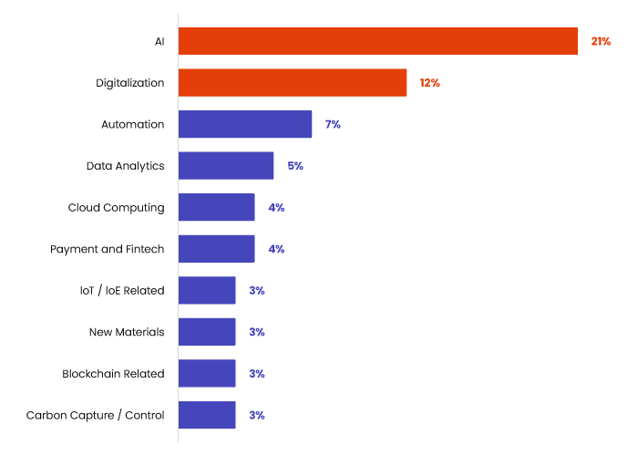
المصدر: استطلاع Gartner لعام 2023 للرؤساء التنفيذيين وكبار المسؤولين التنفيذيين
يمكن استخدام جميع التقنيات المذكورة في حلول برمجية جيومكانية متخصصة بالمجال. وفيما يتعلق بالتقنيات الرئيسية المذكورة أعلاه، تشمل أمثلة التطبيق:
AI
- استخراج الميزات الآلي
- الإسناد الآلي للميزات
- كشف الأجسام وتصنيفها
الرقمنة
- التوائم الرقمية – نماذج الأجسام في العالم الحقيقي
- خوارزميات الدقة الفائقة
- التعميم الآلي
أتمتة العمليات
- حلول RPA/البرمجة المنخفضة/بدون برمجة
- ممارسات DevOps وIaaC
تحليلات البيانات
- معالجة السحابة النقطية
- مواءمة البيانات
- التحليل المكاني
- تحليل البيانات التنبؤي
- التحليل الزمكاني
الحوسبة السحابية
- سحابي المنشأ
- الحوسبة الطرفية
- تحسين تكاليف السحابة
The Gartner survey also demonstrates that IT functions in businesses should fuel innovation, digital transformation, and front-end experience, which are key activities often strongly linked to business development itself. It is an easily noticeable industry change in which we see IT operations becoming one of the most important centres of growth and innovation, not just a cost centre.
بناء المزايا من خلال التكنولوجيا وهندسة البرمجيات
At Spyrosoft, we combine technological expertise, domain knowledge, and consultancy skills to help our clients gain digital and business advantages. Our track record includes successful projects involving mobile and web online mapping platforms, backend improvements and incorporating cutting-edge حلول برمجية جغرافية مكانية تستخدم تقنيات مثل الذكاء الاصطناعي و AR/MR.
Apart from that, we meet clients’ needs by designing and implementing data platforms from scratch or conducting integrations with already existing systems. When creating projects, we use microservices-based architecture, UI/UX, agile methodologies and AWS geospatial cloud services.
>> اعرف المزيد عن شكل العمل مع شريك تطوير برمجيات ذي خبرة من خلال تنزيل كتابنا الإلكتروني المجاني
الدور عليك
استكشف مجموعتنا الواسعة من المشاريع واكتشف كيف يمكن لخبراء Spyrosoft مساعدة شركتك في بناء حلول برمجية جغرافية مكانية فائقة.
قم بزيارة صفحة العرض لمزيد من التفاصيل، أو تواصل معنا عبر نموذج الاتصال أدناه.


arrow_circle_rightاتصل بنا
تواصل معنا واكتشف كيف يمكننا المساعدة

arrow_circle_right مقالاتنا


