Agentic GeoAI: تقديم قيمة تشغيلية عبر استخبارات الموقع


لعقود من الزمن، كان للأنظمة الجغرافية المكانية تأثير في مساعدة المؤسسات على فهم أين تحدث الأمور. من منصات GIS التقليدية إلى الحديثة GeoAI خطوط الأنابيب وتطورذكاء الموقع, the focus has consistently been on improving the accuracy, scale and accessibility of spatial insights. And yet, despite these advances, most geospatial workflows remain fundamentally reactive and dependent on human interpretation. They are fragmented across tools and limited in their ability to translate insight into immediate action.
Agentic AI represents a fresh perspective. Unlike traditional models, which focus solely on analysis or prediction, agent-based systems can reason, plan and act, executing multi-step tasks to achieve defined objectives. In a geospatial context, this takes us beyond static dashboards to solutions that continuously interpret spatial data and trigger real-time operational workflows. Consequently, location intelligence evolves from a passive analytical layer into an active, autonomous engine that can respond directly to real-world events.
This article explores how agent-based AI can be applied in geospatial domains to deliver operational value. It outlines the architectural principles behind such systems, examines key use cases across industries and highlights the technical and organisational challenges involved in transitioning from experimentation to production-ready deployment.
الذكاء الاصطناعي الوكيلي باعتباره أحدث تطور في مجال الاستخبارات الجغرافية المكانية
Geospatial systems have long been designed to support human decision-making by aggregating, visualising and analysing spatial data to generate insights. Traditional AI/ML has extended this case by enabling large-scale prediction like forecasting demand, detecting anomalies, and classifying land use from imagery. However, both approaches remain fundamentally assistive. They produce outputs that still require human interpretation, orchestration, and execution.
Agent-based AI moves from supporting decision-making to executing it autonomously, which is a significant change. At its core, it refers to systems composed of autonomous or semi-autonomous agents that can reason, plan and act within defined operational contexts. Unlike conventional ML pipelines, which are typically stateless and task-specific, agentic systems maintain context over time, breaking down complex objectives into executable steps and interacting dynamically with both data sources and downstream systems.
Spatial workflows are inherently multi-step and context-dependent, often requiring the integration of heterogeneous data (e.g. satellite imagery, IoT, telemetry and vector datasets), domain rules and temporal constraints. Agentic AI enables these workflows to be orchestrated from start to finish, rather than being analysed in isolation.
اطّلع على كيفية استفادتنا من الذكاء الاصطناعي الوكيلي في المجال الجغرافي المكاني!
اكتشف المزيدظهور الأنظمة الجغرافية المكانية القائمة على الوكلاء
The progression of geospatial systems can be understood as a development across three layers. The first is the tooling layer, which includes traditional GIS platforms, dashboards, and analytics environments used for spatial queries, visualisation, and reporting. The second is the intelligence layer, where ML and GeoAI models extend these tools by producing predictions and classifications, such as detecting patterns in imagery or forecasting spatial trends. The third is the emerging agentic layer, where systems leverage insights, autonomously executing decisions and coordinating actions across operational environments.
Agentic AI introduces the ability to break down complex objectives into steps, maintain awareness of spatial and temporal context, and trigger actions through APIs and enterprise systems such as logistics platforms, SCADA, or traffic management systems. Instead of stopping at analysis, systems can now plan, decide, and act within defined boundaries. This change is being enabled by the convergence of المجالات التكنولوجية الرئيسية:
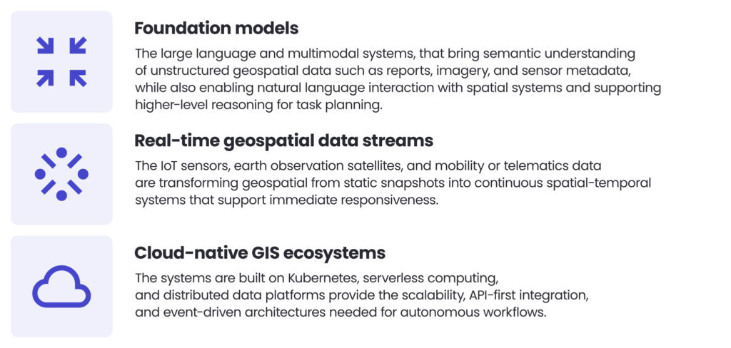
Rather than replacing existing GIS or GeoAI investments, Agentic AI should be seen as a force multiplier for geospatial operations. By embedding autonomous decision-making into spatial workflows, organisations can reduce the time between insight and action from hours or days to seconds, scale operations without proportional increases in human effort, standardise complex decision-making across regions and adapt continuously to changing spatial conditions. In this model, location intelligence evolves into an operational control layer that explains what is happening in space and increasingly helps to shape what happens next.
ما الذي يجعل نظام الذكاء الاصطناعي وكيليًا
An AI-based system becomes agentic when it actively pursues goals within an environment, adapting its behaviour based on context and feedback. This development is especially important in geospatial as spatial problems are inherently multidimensional, incorporating location, time, uncertainty, and operational constraints. The most fundamental characteristic of agentic behaviour is goal orientation. Rather than responding to isolated queries or running fixed models, the system operates against defined objectives, such as reducing delivery delays, maintaining infrastructure resilience or optimising resource allocation across a network. This leads the system’s function from producing outputs to achieving outcomes, fundamentally altering how geospatial intelligence is operationalised.
ولتحقيق ذلك، تعتمد الأنظمة الوكيلة يجب أن تكون قادرة على التفكير متعدد الخطوات على البيانات المكانية. They decompose objectives into sequences of interdependent actions, involve combining spatial queries, routing computations, raster analysis and clustering techniques within a coherent decision-making process. Importantly, this reasoning is iterative, with intermediate results influencing subsequent steps. This enables the system to handle spatial relationships, temporal changes and operational constraints simultaneously.
القدرة الحيوية الثانية هي استخدام الأدوات وتكامل الأنظمة. Agentic geospatial systems are orchestrators of external capabilities, and interact directly with GIS services, spatial databases like PostGIS, cloud data warehouses, raster processing engines and enterprise APIs. يتيح لهم ذلك تحليل البيانات المكانية وتشغيل سير العمل التشغيلي، مما يسدّ الفجوة بين الاستخبارات والتنفيذ بشكل فعال.
An agentic geospatial system is not defined by the models it uses, but by its ability to reason iteratively across spatial constraints, orchestrate tools, and refine decisions through feedback. It definitely transforms GIS from a query engine into a decision-making entity.
ياريك مارتشينياك، مدير خدمات المعلومات الجغرافية المكانية
Equally important is the concept of memory and context awareness. Unlike stateless pipelines, agentic systems maintain persistent representations of spatial and temporal context. This includes historical states of the environment, evolving spatial relationships and feedback from prior actions. Memory enables the system to maintain continuity over time, adapt decisions based on long-term trends, and avoid repeating ineffective strategies.
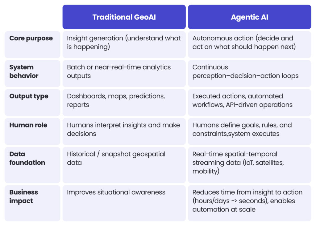
يتضح التمييز عند المقارنة بأنظمة GeoAI التقليدية.
كيف يغيّر الذكاء الاصطناعي العمليات الجيومكانية الأساسية
إن الجمع بين تعلّم الآلة والأنظمة الوكيلية الناشئة يعيد تشكيل سير العمل اليدوي والبطيء والمتخصص للغاية بشكل جذري في جميع أنحاء صناعة البيانات الجغرافية المكانية.
استخراج الميزات الآلي على نطاق واسع
One of the most significant shifts is in the area of automated feature extraction on a large scale. What once required human analysts to painstakingly digitise roads, buildings and land cover from aerial and satellite imagery can now be achieved through ML-powered pipelines. In collaboration with the Ordnance Survey, we developed a system that can process multi-spectral imagery and identify real-world features with over 90% precision. This has scaled up base map creation across more than 50 countries and reduced the time previously required by an order of magnitude. Building on these models, agentic orchestration now enables systems to autonomously decide where reanalysis is needed based on detected change signals, not only extracting features.
التوصية الذكية للمسارات والمواقع المكانية
A similar transformation is occurring in intelligent route and spatial recommendations. Here, raw geospatial data must be interpreted in context before it can be used to inform decisions. For the OS Maps application developed by Ordnance Survey، تم استخدام نماذج التعلم الآلي لتقييم مسارات المشي وركوب الدراجات من خلال تحليل الارتفاع والجغرافيا والسمات الوصفية. وقد حقق هذا النهج معدل دقة بلغ 70-85% في predicting user satisfaction, enabling the automatic rating of new routes on a large scale. With agentic enhancement, these systems can go further, dynamically incorporating real-time inputs such as weather, footfall and seasonal accessibility to continuously re-rank spatial recommendations in response to natural language queries.
إدارة خطوط البيانات المستقلة
Finally, agentic AI is beginning to transform the invisible backbone of geospatial systems in autonomous data pipeline management. It monitors complex multi-source data flows, detects schema drift or quality degradation, and triggers remediation workflows before issues escalate. This enables organisations to transition from reactive maintenance to a proactive, self-healing approach to geospatial infrastructure, capable of sustaining petabyte-scale operations with minimal human intervention.
الفوائد التشغيلية للذكاء الاصطناعي الوكيلي في المعلومات الجغرافية المكانية
- معالجة بيانات مستقلة ودورات قرار أسرع
Agentic AI enables the autonomous handling of geospatial data workflows, from collection and analysis to updating. It processes inputs such as satellite imagery or sensor data continuously, eliminating the need for manual intervention and significantly reducing the time between data acquisition and gaining actionable insights. - مراقبة قابلة للتوسع وعمليات تنبؤية
It provides the continuous monitoring of large-scale geospatial environments and applies predictive models to detect patterns and anticipate future events. The system dynamically adapts to incoming data, enabling organisations to identify risks and opportunities before they materialise. - تحسين الموارد وكفاءة التكلفة
The use of agentic technology optimises the allocation and utilisation of resources across geographically distributed operations. It achieves this by automating repetitive analytical tasks and improving decision precision, thereby reducing operational overheads and enhancing the efficiency of field activities and infrastructure use. It achieves this by automating repetitive analytical tasks and improving decision precision, thereby reducing operational overheads and enhancing the efficiency of field activities and infrastructure use.
الخلاصة
Over the years, the industry has moved progressively from static mapping to analytics-driven GIS and, most recently, to predictive GeoAI models. Each step has improved our understanding of spatial environments. However, the underlying operating model has remained largely unchanged: geospatial systems inform decisions, but humans still execute them.
Agentic artificial intelligence breaks this dependency by introducing systems that can reason, plan and act. Geospatial intelligence is now operational by design. Rather than producing insights that remain in dashboards or reports, spatial systems can now interpret the environment continuously, evaluate options and trigger actions across connected enterprise ecosystems. The real value of this change emerges when spatial intelligence forms a continuous loop connecting data, context, decision-making and real-world action. In this model, location intelligence becomes an operational capability that is always on, responsive, adaptive, and increasingly autonomous. At the same time, the transition to agentic geospatial systems introduces real-world complexity. This requires robust data engineering foundations, trusted AI models, secure system integration and careful governance to ensure that autonomy operates within clearly defined boundaries.
استفد إلى أقصى حد من خبرتك في المعلومات الجغرافية المكانية من خلال تحويلها إلى قدرة تشغيلية للذكاء الاصطناعي
يجمع فريقنا الجيومكاني بين خبرة هندسية عميقة في نظم المعلومات الجغرافية (GIS) وسجل حافل مُثبت فيتسليم الذكاء الاصطناعي وتعلم الآلة، بما في ذلك خبرة واسعة في تطبيقات الذكاء الاصطناعي الجغرافي على المستوى الوطني.
نساعد المؤسسات على الانتقال من التجريب في مرحلة إثبات المفهوم إلى أنظمة تشغيلية قادرة على معالجة البيانات المكانية والاستدلال عليها واتخاذ إجراءات بناءً عليها في بيئات الإنتاج. اتصل بنا لمناقشة متطلباتك ومعرفة كيف يمكن للأنظمة الجغرافية المكانية الوكيلة تحويل ذكاءك المكاني إلى قدرة تشغيلية ذاتية.
In geospatial, agentic AI refers to systems that can analyse spatial data, make decisions, and execute actions autonomously. This transforms location intelligence from a passive tool for gaining insights into an active operational capability that responds to real-world events in real time.
Traditional GeoAI is focused on generating insights, such as predictions or classifications, that still require human interpretation and action. In contrast, Agentic AI goes further, enabling systems to act on insights without constant human involvement by reasoning, planning and executing multi-step workflows.
Agentic AI reduces the time between gaining an insight and taking action, enabling faster decision-making and large-scale automation. It also improves resource efficiency and supports continuous monitoring, allowing organisations to respond dynamically to changing spatial conditions.
It can be used for automated feature extraction, intelligent routing and recommendation systems, and autonomous data pipeline management. These use cases help organisations to scale their operations, improve their accuracy, and maintain high-quality geospatial data while keeping manual effort to a minimum.
Key challenges include establishing robust data engineering foundations, integrating with existing systems, and maintaining governance over autonomous decision-making processes. In order to safely deploy agentic systems at scale, organisations must also address issues of trust and security, and establish clear operational boundaries.


arrow_circle_rightاتصل بنا
لنتواصل للتحقق من كيفية دعم خبرائنا لمشروعك

arrow_circle_right مدونتنا