مقابلة مع خبير تعلم الآلة في Spyrosoft: الفائز في مسابقة Kelp Wanted


The ability to make effective use of data is now not only a key element of development, but also often a determinant of success. As a leading technology company, we are characterised not only by innovation in the field of IT solutions, but also by an impressive team of experts!
لذلك يسعدنا أن نقدم لكم ميخال فييرزبينسكي، كبير علماء البيانات لدينا، الذي حصل على المركز الثاني في مسابقة Kelp Wanted. في هذه المقابلة، نستعرض مسار Michal للفوز بالمسابقة والفرص التي يتيحها العالم المتغير ديناميكياً لتحليل البيانات و الذكاء الاصطناعي.
ما كان الهدف الأساسي للمسابقة، وما حل تعلم الآلة الذي طورتموه؟
هدفت المسابقة إلى تطوير خوارزميات قادرة على اكتشاف وجود أو غياب غابات عشب البحر في صور القمر الصناعي Landsat. تطلبت هذه المهمة تعلم الآلة، ومعرفة معالجة الصور، وفهم عميق لسياق البيئة ودقائق البيانات الجغرافية المكانية.
Kelp forests are crucial ecosystems, rich in biodiversity and serving various ecosystem functions, such as providing habitat for fish or coastal communities. However, environmental changes increasingly threaten kelp forests, prompting organisations like Kelp Watch to take protective and monitoring actions to safeguard these ecosystems.
As part of the competition, organisers wanted to see how others approached this problem to gain new insights into monitoring kelp forests. They provided participants with satellite data from the Landsat platform, which has been collecting satellite images since 1972. This data was used to conduct semantic segmentation analysis, allowing for the identification of areas of kelp forests in satellite images. I must admit that I had prior experience working with this type of data for our clients on projects such as a platform on Azure for monitoring mining areas and their environmental impact, segmentation of mining site areas, land cover classification and change detection. This experience allowed me to effectively utilise various techniques in analysing these images. I ultimately developed a precise model, the second-best out of 671 submissions worldwide, with درجة DICE البالغة 0.7318.
The topic of the model itself is technical. It is based on a neural network and the U-net architecture, which is widely popular worldwide, especially in semantic segmentation. The features for this network are derived from the EfficientNet encoder. During the competition, I spent most of the time exploring the data. Initially, I used the U-Net architecture with ResNet-50 encoder, making it easier for me to start work, achieve reasonable results, and provide opportunities for further optimisation. Throughout the first half of developing my solution, I was mainly experimenting with the data. I split the data into 10-fold cross validation sets.
ومع ذلك، سرعان ما اكتشفت أن البيانات المقدمة لم تكن نظيفة بما فيه الكفاية – كما نحب أن نقول في هذه الصناعة: مدخلات رديئة، مخرجات رديئة. كان عليّ تحسين هذه البيانات. خلال هذه العملية، لاحظت وجود التكرارات in the dataset. Although they cover the same area, they are observed from different revisit times and orbits, leading to the data leakage across the folds. There were even up to 200 duplicates for one area, requiring the application of embedding techniques and cosine distance. I reduced similar images into similar groups from 5000 إلى 3000 مواقع فريدة.
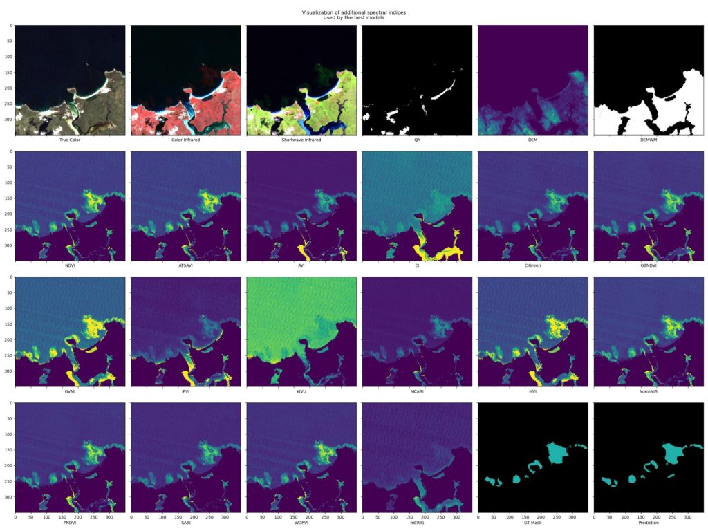
About two fifths of the entire data set consisted of open water images. After generating the groups, I felt more confident, as if my model performed well on the training and validation sets, it means the model will be able to generalise to other areas. It’s worth noting that as participants, we had access to metrics calculated on a subset of the test dataset, the final scoring was being done on remaining portion of the dataset. During experiments, I tried various loss functions and data normalisation techniques, but the most significant success turned out to be adding separate spectral indices. Satellite images have various spectral data, such as near-infrared, short wave infrared, etc. I used them to create indices that are commonly used for detection of stressed vegetation or the creation of water mask. After a few days of training, it turned out that a combination of an additional 17 indices worked well and were crucial for improving the model’s effectiveness. I also applied model ensemble techniques to improve results. Each pixel is classified as 1 or 0, indicating the presence or absence of kelp forest, and then an appropriate value is assigned through weighted averaging. This strategy further improved the model’s results and achieved significant accuracy in kelp forest segmentation on satellite images.
من أين جاءت فكرة تطوير مثل هذا الحل؟
The idea for developing such a solution mainly stemmed from my previous experience working with satellite data and numerous projects I had undertaken at Spyrosoft and throughout my professional career. Having domain knowledge in this field, I decided to leverage my expertise to devise this comprehensive solution. It’s worth noting that my iterative approach played a crucial role. Initially, I approached the project straightforwardly, focusing on implementing basic elements. Then, gradually and methodically, I expanded the solution, experimenting with various techniques and methods to achieve the best results. Thanks to this approach, I successfully developed an effective solution that met the set goals and expectations regarding the development of the kelp forest detection algorithm.
ما التحديات التقنية التي واجهتموها أثناء تطوير الخوارزمية للكشف عن الغطاء الطحلبي على صور الأقمار الصناعية، وما الخطوات التي اتخذتموها لمعالجتها؟
I encountered several significant technical challenges while developing the algorithm for detecting kelp cover on satellite images. The first was the issue of data quality and segmentation masks, which could have been more optimal. The metric used for evaluation did not exceed 75%، مما يشير بوضوح إلى عدم اكتمال عملية تصنيف البيانات.
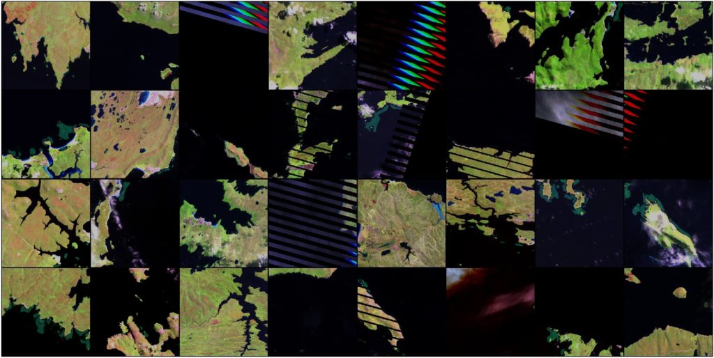
Additionally, Landsat data suffered from various imperfections, including striping in some visualisations caused by satellite malfunction and being clipped into a specific tile grid. These introduced additional challenges, especially in the context of lacking information about geolocation of the tiles. To address these issues, it was necessary to employ ‘area of interest’ grouping techniques to achieve the most precise results possible.
ما الطرق الأخرى التي يمكن بها استخدام تعلم الآلة للمراقبة البيئية؟
Assessing the state of the environment through machine learning offers diverse opportunities for monitoring and protecting ecosystems. ML can be used to predict levels of air pollution based on sensor data and satellite imagery, monitor water quality, predict threats to water resources, or monitor mining areas to understand the extent of exploration of various minerals and their potential extraction. Additionally, analysing data from drones, satellite images, and sensors can help in precision agriculture industry or in forestry services by monitoring the health of forests, identifying areas at risk of droughts, fires and floods, and protecting endangered animal species.
Machine learning can aid in predicting natural disasters through the analysis of historical data on phenomena such as earthquakes and hurricanes. Additionally, it facilitates monitoring climate change by examining meteorological data and levels of greenhouse gases. This technology further assists in biodiversity conservation through the analysis of species occurrence data and their habitats.
ما الفوائد التي يمكن أن يحققها عملاؤنا الذين يستخدمون تعلم الآلة لتحليل صور الأقمار الصناعية؟
Using machine learning for satellite image analysis can bring numerous benefits to our clients. Employing machine learning technology to analyse data from social media feeds enables rapid identification of various news categories, allowing for the automatic assignment of satellite data acquisition from these areas within minutes, providing clients with a lightning-fast response to the latest events, and optimising resource utilisation. Through ML algorithms, automatic processing of satellite images and generation of precise maps is possible, which is particularly useful in urban planning, monitoring environmental changes, and in the agricultural sector for crop optimisation. Machine learning systems regularly scan satellite images, detecting changes in terrain and enabling a quick response to threats or opportunities.
Additionally, satellite image analysis using ML supports monitoring natural resources such as forests, rivers, or water reservoirs, which can be utilised for resource management and combating illegal practices, such as deforestation. It’s worth noting that satellite data can be used to forecast atmospheric phenomena such as storms, floods, or droughts, aiding in preventive actions and crisis management. Monitoring infrastructure through ML allows for the automatic detection of damages or failures, enabling swift intervention and repair. Satellite images can also be used to monitor endangered areas and allow a quick response to potential security threats.
ما التحديات البيئية التي تراها الأكثر إلحاحًا اليوم، وكيف يمكن للتعلم الآلي أن يساعد في معالجتها في المستقبل؟
In contemporary environmental challenges, utilising technology, including machine learning, becomes crucial in solving these problems. One of the most pressing issues is climate change, resulting in rising global temperatures, extreme weather phenomena, the loss of glaciers, rising sea levels and food security issues, especially in less developed countries.
ML can assist in forecasting and monitoring these changes by analysing large amounts of climate data. Additionally, the depletion of natural resources such as water, soil, forests, and minerals threatens ecological balance and sustainable development. The use of machine learning algorithms can contribute to optimising the consumption of these resources across various sectors, allowing for more sustainable utilisation.
Air, water, and soil pollution are also significant environmental challenges. ML-based systems can monitor pollutants and identify their sources, enabling practical corrective actions. This technology can also be utilised to analyse biodiversity data, identify areas requiring protection, and take action to preserve biological diversity.
Moreover, machine learning can support the development of sustainable innovations, such as renewable energy sources and more efficient production processes, thereby reducing human activity’s negative environmental impact.
هل تبحث عن شريك في تكنولوجيا المعلومات الجغرافية المكانية؟
اكتشف المزيد حول الخدمات الجغرافية المكانية أو تواصل معنا باستخدام النموذج أدناه.
لنناقش كيف يمكن لفريق خبرائنا المساعدة في مشروعك القادم!


arrow_circle_rightاتصل بنا
تواصل معنا واكتشف كيف يمكننا دعم مشروعك في مجال المعلومات الجغرافية المكانية

arrow_circle_right مقالاتنا