Les avantages des transformers dans la reconnaissance automatisée des bâtiments


The development of automated detection technologies has opened new possibilities for analysing urban spaces with speed, accuracy and cost-effectiveness. Advanced technologies combined with transformer models such as Real-Time DEtection TRansformers are taking the field of Geo AI en avant, permettant une reconnaissance automatisée instantanée des bâtiments et une délimitation précise dans l'imagerie satellite ou aérienne.
Il existe une tendance croissante dans l'analyse géospatiale pilotée par l'IA, où machine learning les modèles optimisent les flux de travail spatiaux en automatisant extraction de données et l'amélioration de la précision dans les projets à enjeux élevés. À mesure que la technologie progresse, les modèles de reconnaissance promettent d'améliorer les résultats opérationnels dans divers domaines, démontrant le potentiel de transformation de l'IA dansgéospatial applications.
In this article, we introduce how transformers are revolutionising geospatial analysis with real-time detection, improved accuracy, and significant cost savings, as well as its applications in various industries and its important role in the automated building recognition project.
Que sont les Transformers et comment fonctionnent-ils ?
Les transformers sont une architecture de réseau de neurones conçue pour traiter des séquences, telles que du texte, en comprenant le contexte et les relations au sein des données. Ils peuvent gérer des dépendances à longue portée, ce qui les rend particulièrement efficaces pour des tâches telles quetraitement du langage naturel (NLP). Transformers work through two key innovations. The first is self-attention, a mechanism that evaluates how different parts of a sequence relate to each other, allowing the model to capture dependencies across the input. The second is parallel processing, which allows the analysis of entire sequences simultaneously rather than step-by-step.
En combinant compréhension contextuelle avec évolutivité, transformers have become central to advances in modern AI, extending their impact beyond NLP to areas such as vision and geospatial analysis. For example, Vision Transformers (ViTs) leverage the transformer architecture to process image data by breaking it into patches, analysing relationships between patches, and excelling at tasks like image classification, object detection, and segmentation.
Découvrez notre offre géospatiale
En savoir plus
Qu'en est-il du RT-DETR ?
Real-Time Detection Transformer is an advanced machine learning model designed for fast and accurate object detection. It uses transformer-based neural networks to process visual data in parallel, making it ideal for real-time applications such as detecting and outlining buildings in urban areas. By exploiting attention mechanisms, RT-DETR focuses on relevant image details and efficiently identifies objects and their contours, even in dense or cluttered scenes. This family of models eliminates the need for costly Non-Maximum Suppression usage, which negatively affects popular alternatives, such as YOLO models. RT-DETR often outperforms YOLO models of similar size. This technology is perfect for applications that require accurate, real-time object recognition.
En quoi les transformers diffèrent-ils des autres architectures de réseaux neuronaux
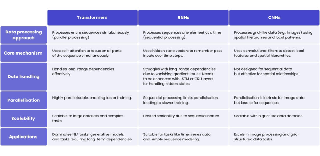
Think of a traffic control tower equipped with radar systems that can instantly monitor all airplanes in the sky, regardless of their distance. The control tower doesn’t need to watch planes in the order they take off or land. Instead, it has a complete bird’s-eye view, identifying patterns and connections across the entire airspace at once. This is how transformateurs travail. Ils traitent toutes les données d'entrée simultanément et utilisent des mécanismes d'attention pour se concentrer sur les parties les plus pertinentes des données. Par exemple, ils peuvent identifier que « l'avion A », qui a décollé il y a une heure, est pertinent pour « l'avion B », qui atterrit maintenant, sans avoir besoin de traiter chaque vol intermédiaire.
Now, picture an air traffic controller who has to watch planes take off and land one by one in a strict sequence. To understand what’s happening, they must recall what they saw earlier – building context as they go. For instance, if they saw “plane C” land earlier, they use that memory to decide whether to clear “plane D” for takeoff. This is the way the réseaux de neurones récurrents (RNN) fonction. Ils traitent les données de manière séquentielle, étape par étape, et sont particulièrement adaptés à des tâches telles que la prédiction du mot suivant dans une phrase ou l'analyse de séries temporelles, où le contexte passé est essentiel.
Pour comprendre comment réseaux de neurones convolutifs (CNN) work, imagine scanners placed along airport runways that analyse each section of a plane as it passes. These scanners only look at small sections at a time, but together they form a complete picture of the plane’s condition. They’re great for checking localised details, like whether the plane’s landing gear is down, or its engines are working properly, and for visual tasks, such as identifying objects in an image.
Applications de RT-DETR dans l'analyse géospatiale
This technology has a major impact on many industries where geospatial analysis is essential, streamlining processes through its ability to deliver accurate, real-time data. Here are some of the industries where RT-DETR is beneficial, and how its capabilities meet the unique needs of each.
Urbanisme et développement des infrastructures
It aids urban planners and developers by quickly and accurately identifying buildings, roads and other urban features. RT-DETR supports monitoring urban growth, updating city maps, and optimising resource allocation. By identifying underutilised or high-demand areas, it enhances zoning decisions and infrastructure planning. The technology also assists in recognising non-structural elements like green spaces, car parks, and waterways for comprehensive urban development.
Immobilier et évaluation de biens
Real estate companies and government agencies benefit from RT-DETR’s ability to automate the detection and measurement of built-up areas, roads, and landscape features like parks or water bodies. This ensures consistent, accurate data even in densely populated or complex environments, aiding in property assessment and valuation.
Gestion des catastrophes et intervention d'urgence
In emergencies, this advanced technology provides real-time recognition of buildings, roads, and natural barriers, which is critical for assessing vulnerability, planning evacuation routes, and deploying resources. RT-DETR can identify changes in the landscape caused by natural disasters, like flooded areas or collapsed structures, enabling quicker and more efficient response coordination.
Défense et sécurité
It supports strategic planning by detecting changes in infrastructure, road networks, and other key features across regions. It is invaluable for border security operations, surveillance, and defence planning, helping to monitor urban growth, identify potential security threats, and optimise patrol routes.
Surveillance et protection de l'environnement
RT-DETR plays an essential role in tracking changes in natural landscapes, such as deforestation, urban encroachment on protected areas, and habitat loss. Its ability to recognise features like rivers, vegetation cover, and artificial structures supports enforcement of environmental policies and aids in sustainable development. It also helps monitor the impact of human activity on ecosystems, ensuring informed conservation efforts.
Real-Time DEtection TRansformer dans la reconnaissance automatisée de bâtiments
Accurate building recognition is key to many urban planning and real estate applications, but accurately identifying buildings in large datasets can be challenging. One of our clients required a system that could efficiently recognise buildings and, ideally, generate an outline of each building – a feature rarely found in conventional recognition tools. Overcoming this challenge needed an advanced approach that could provide both fast recognition and accurate structural mapping.
To meet the client’s needs, we developed a robust building recognition system using Real-Time DRtection TRansformer technologies as the main recognition framework. We adapted the RT-DETR model to the building recognition task to increase accuracy and stability. To add value to the building outline generation, we integrated Segment Anything Model (SAM) pour fournir une segmentation des bâtiments précise et évolutive.
Pour améliorer les performances sur les images plus grandes et détecter les petits objets qu'elles contiennent, nous avons exploité vision par ordinateur et Slicing-Assisted Hyper-Inference (SAHI), ce qui a considérablement augmenté les capacités du système en segmentant les données visuelles et en permettant la détection de petits objets sans réentraînement approfondi du modèle.
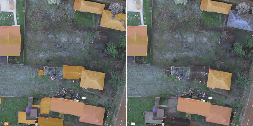
En résumé, la solution se compose de 4 éléments clés :
1. Segmentation d'images – Le processus commence par SAHI, qui divise l'image d'entrée en tuiles plus petites qui se chevauchent à l'aide d'une technique de fenêtre glissante. Cela permet une meilleure gestion des grandes images et une amélioration de la détection des petits objets tels que les toits.
2. Génération de masques – Chaque tuile est ensuite traitée par FastSAM, qui génère des masques de segmentation précis pour les bâtiments potentiels au sein de chaque tranche.
3. Classification avec RT-DETR affiné – Les masques de segmentation générés par FastSAM sont ensuite classifiés par un modèle Real-Time Detection Transformer (RT-DETR) affiné, spécifiquement entraîné sur des images de toitures, afin de garantir une détection et une classification précises des structures de bâtiments.
4. Réassemblage et agrégation des masques – All processed slices and their corresponding segmentation masks are re-assembled into a coherent image. Overlapping areas are reconciled by aggregating the coloured masks, effectively creating a unified building outline that is both accurate and scalable.
After implementing the solution, the client received excellent results. The system accurately identifies buildings in real-time and can generate clear and detailed outlines. In addition, SAHI ensured that even small structures in large images could be identified without sacrificing processing speed. The solution improved operational efficiency and increased the accuracy of the client’s urban analysis data.
Integrating Real-Time DEtection TRansformer with advanced technologies such as SAHI and SAM has enabled us to address one of the biggest challenges in urban data analysis – scalable and accurate building detection. This solution gives our client a competitive advantage by combining speed with exceptional detail in real-time building outline generation.
Piotr Semberecki, Senior AI Data Scientist chez Spyrosoft
Principaux avantages des DEtection TRansformers en temps réel
Détection d'objets de haute précision
RT-DETR utilise des transformers pour se concentrer sur des parties spécifiques de l'image, capturant les contours détaillés des objets et les formes complexes, ce qui améliore la précision, en particulier dans les groupes ou scènes complexes où des limites précises sont essentielles.
Rapidité et efficacité
Les modèles RT-DETR excellent dans le traitement rapide de grandes quantités de données. Ils peuvent effectuer une détection d'objets et une segmentation d'images rapides sans latence significative grâce aux mécanismes d'attention des transformers et au traitement parallèle.
Réduction du besoin de traitement manuel des données
Il automatise le processus d'identification et de segmentation des objets, ce qui permet d'économiser du temps et des ressources et de permettre aux professionnels qualifiés de se concentrer sur l'analyse de haut niveau et la planification stratégique.
Robustesse
Il garantit des résultats fiables même dans des conditions dynamiques. Par exemple, un faux positif dans une image est atténué dans les images suivantes, minimisant l'impact sur la précision globale de la détection.
Polyvalence sectorielle
La flexibilité de RT-DETR le rend particulièrement polyvalent et utile dans divers secteurs. Chaque secteur peut appliquer cette technologie pour répondre à ses besoins spécifiques et améliorer la qualité de la prise de décision grâce à des données spatiales fiables et actualisées.
Transformez votre analyse géospatiale avec Spyrosoft
Fort de notre expérience en solutions géospatiales avancées, nous pouvons adapter les technologies les plus récentes aux besoins spécifiques de votre secteur, vous aidant à prendre des décisions plus rapides, plus intelligentes et mieux informées.
Contactez nos experts en géospatial aujourd'hui pour découvrir comment les transformers peuvent transformer vos projets et vous donner un avantage concurrentiel grâce à des insights exploitables et opportuns !
FAQ : Reconnaissance automatisée des bâtiments
Transformers are advanced deep learning architectures that excel at processing complex data patterns. In the context of building recognition, they facilitate the more accurate extraction of building footprints from satellite imagery by effectively capturing spatial relationships and contextual features across entire images.
Unlike CNNs, which focus on local features, Transformers use self-attention mechanisms to analyse global patterns within an image. This enables them to detect building shapes and boundaries more accurately, particularly in cluttered or complex urban environments.
Transformers offer enhanced accuracy, scalability and generalisation when processing satellite data. They perform well in different geographic regions and can be trained using large datasets to recognise various architectural patterns, thereby reducing the need for extensive manual labelling or rule-based systems.
Yes, although transformers offer high levels of accuracy, they demand substantial computational resources and extensive annotated datasets for effective training. Furthermore, achieving optimal performance while maintaining precision across different environments can be complex and time-consuming.
These models support a variety of applications, including urban planning, disaster response, infrastructure monitoring and updating maps. Automated, accurate building detection enables governments, engineers and geospatial analysts to make informed decisions quickly and efficiently.


arrow_circle_rightnous contacter
Contactez-nous pour vérifier comment nos experts pourraient soutenir votre projet

arrow_circle_right Nos articles