Rassembler les données satellitaires – simple, intelligent et pour tous


Satellite data has become one of the most powerful tools in our efforts to understand and manage our rapidly changing planet. Earth Observation satellites provide a continuous, real-time record of the world around us. However, while the volume and value of this data continues to grow, so too do the barriers preventing its full utilisation.
For many professionals in various sectors, EO data remains frustratingly out of reach. It is scattered across platforms, hidden behind technical barriers or locked away in formats that require specialist knowledge to interpret. Despite the clear demand for spatial insights, the majority of EO data today remains unused. This is the challenge being addressed by a new generation of tools that transform how we access, analyse and act on satellite data.
Dans notre récente intervention à GeoBusiness 2025, we explored how EO DataHub and tools such as EOPro are transforming satellite data into a truly inclusive resource that is simple, smart, and poised to make a real impact. In this article, we’d like to introduce these tools in more detail, explore how they are bridging the gap between complex satellite datasets and everyday decision-making, and share the opportunities they create for industries, communities, and the planet.
Des données satellitaires fragmentées et difficiles à utiliser
With our planet under pressure, up-to-date information is essential. Earth Observation (EO) data, gathered daily by satellites orbiting above us, provides a valuable means of understanding and responding to these changes. It captures everything from shrinking glaciers to the expansion of urban areas and generates over 150 téraoctets de nouvelles données par jour.
Malgré le potentiel immense de ces données, comme en témoignent les projections qui estiment le marché des données d'observation de la Terre à12 milliards de dollars d'ici 2031, une grande partie reste inutilisée. En fait, jusqu'à 80 % of EO data goes unused, largely due to hurdles such as limited access, a shortage of technical expertise, and the daunting complexity of data formats and platforms. These challenges hinder government agencies, educators, NGOs, businesses and researchers, all of whom could benefit from these insights.
Découvrez comment nous exploitons les données satellitaires !
En savoir plus
EO DataHub – la salle des machines des insights EO
Launched in 2023 as part of the UK’s Pathfinder programme, the EO DataHub is the result of a national effort to simplify and increase the use of Earth observation data. With backing from nearly £10 million in funding and developed through a coalition of public institutions and private sector partners, the platform was designed to act as a ‘Grand Central Station’ for satellite data – providing a single point of access to public and commercial EO resources across the UK.
EO DataHub goes far beyond data aggregation. It provides a unified, cloud-native environment in which users can find, process and analyse EO data, eliminating the need to switch between tools or platforms. Ready-to-run analytical workflows, such as land cover classification and water quality indexing, enable users to swiftly transform raw data into meaningful insights. The system supports a wide range of user profiles, offering intuitive, no-code tools for beginners and full API-level access for advanced users and developers.
Conçu pour la performance en temps réel et bâti sur des standards ouverts, EO DataHub permet déjà des applications à fort impact, telles que :
- EOPro, un environnement visuel no-code pour l'exploration et l'analyse guidées des données d'observation de la Terre (EO),
- CLARAT est un outil de validation atmosphérique co-développé avec des climatologues.
Découvrez EOPro et voyez comment il transforme les données en actions
Comme nous l'avons mentionné au début, le problème avec les données d'observation de la Terre n'est pas qu'elles sont rares, mais qu'elles sont fragmentées et complexes, et qu'il existe des barrières techniques empêchant la plupart des utilisateurs d'accéder à leur plein potentiel.
Chez Spyrosoft, nous avons développé EOPro en partenariat avec the Satellite Applications Catapult pour relever ces défis. En tant que portail web no-code, intégré de manière transparente à l'EO DataHub, EOPro réinvente la façon dont les utilisateurs interagissent avec les données satellitaires.
EOPro offre une plateforme unifiée et intuitive grâce à laquelle les utilisateurs, quel que soit leur niveau technique, peuvent facilement accéder aux données d'observation de la Terre, les analyser et les visualiser.
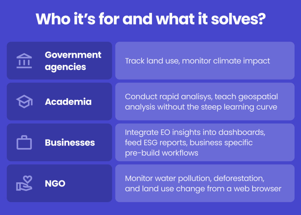
At the heart of EOPro lies a visual tool that empowers users to build custom geospatial workflows by arranging analysis steps within a simple drag-and-drop interface. Whether the task involves generating land cover maps, monitoring water quality or tracking environmental changes over time, EOPro enables users to transform raw data into actionable insights with just a few clicks. The platform supports both predefined workflows for common scenarios and the flexibility to design bespoke analyses, making it valuable and accessible for government agencies, academics, businesses and NGOs alike.
Du simple bouton à la puissance – quelle est la prochaine étape ?
EOPro et EO DataHub continuent d'évoluer. Les développements à venir incluent des niveaux d'accès flexibles, l'intégration avec des jeux de données commerciaux et tiers, des flux de travail améliorés par l'IA et la prise en charge des données fournies par les utilisateurs, comme les mesures in situ.
En conclusion
GEO Business 2025 served as a reminder that the geospatial field is shifting from an era of data abundance to one of data empowerment. The tools we develop should facilitate actionable insights, not merely information access. At Spyrosoft, we see our role as facilitating this change by helping organisations use EO data to plan more sustainably, respond more quickly and innovate more intelligently.
Ainsi, si vous souhaitez faire passer votre analyse de données au niveau supérieur, nos experts sont là pour vous aider. Contactez notre équipe pour découvrir comment nous pouvons accompagner votre organisation dans l'exploitation optimale des données satellitaires.
Après tout, la Terre nous parle à travers chaque signal, chaque schéma et chaque changement. C'est maintenant à notre tour d'écouter.
Les principaux défis sont la fragmentation des données sur de multiples plateformes, la complexité technique des formats et des outils, l'accessibilité limitée en raison des coûts ou des licences, et le volume écrasant d'informations, dont une grande partie reste inutilisée.
EO DataHub is a unified platform developed under the UK’s Pathfinder programme that brings together public and commercial satellite data. It simplifies access, enables users to search and analyse data in one place, and offers ready-to-use workflows as well as APIs, making Earth Observation data easier to use for both beginners and advanced users.
EOPro is a no-code, web-based portal that works with EO DataHub, designed to let users visualise and analyse satellite data without technical expertise. It features drag-and-drop workflows and predefined tools, making it accessible to government agencies, researchers, NGOs, businesses, and anyone who needs spatial insights.
Les projets futurs incluent des niveaux d'accès flexibles, l'intégration avec davantage d'ensembles de données commerciales, des workflows pilotés par l'IA et la possibilité pour les utilisateurs d'intégrer leurs propres données, le tout visant à améliorer l'ergonomie et à élargir l'impact des données satellitaires.


arrow_circle_rightnous contacter
Contactez-nous pour découvrir comment nos experts peuvent soutenir votre projet

arrow_circle_right notre blog