Infrastructure ESG : pourquoi les données de localisation sont incontournables pour le reporting de durabilité


Sustainability reporting is moving to a system based on continuous monitoring, verifiable evidence, and quantifiable environmental impact. Geospatial technology is leading this change, establishing itself as a core part of ESG infrastructure amid growing regulatory and stakeholder pressure.
The Corporate Sustainability Reporting Directive and the EU Taxonomy are prompting organisations to utilise Earth Observation, GIS and GeoData Engineering to monitor land use changes, assess climate risk, track the impact on biodiversity and support ESG reporting with location-based evidence.
This shift is particularly evident in the DACH and Nordic markets, where ESG and compliance requirements are particularly stringent. Companies are increasingly recognising that challenges such as emissions, supply-chain transparency, flood exposure and biodiversity loss are geography linked issues that require geospatial intelligence.
Cet article explore comment les technologies géospatiales soutiennent la conformité ESG et CSRD, l'importance stratégique de l'ingénierie des géodonnées, et comment les organisations peuvent bâtir des cadres de reporting de durabilité évolutifs et prêts pour l'audit.
Ce qui explique l'augmentation de l'utilisation du géospatial pour l'ESG
ESG reporting is progressing from voluntary disclosure to strict regulatory accountability. Across Europe, frameworks like the Corporate Sustainability Reporting Directive and the European Sustainability Reporting Standards are significantly raising the bar for transparency, auditability and data quality.
Ce changement crée une demande croissante de données traçables et géolocalisées. Les métriques liées à les émissions, l'utilisation des terres, la biodiversité, le stress hydrique ou l'exposition climatique sont intrinsèquement spatiaux et il est souvent impossible de les valider sans contexte géospatial. À mesure que les exigences d'assurance ESG deviennent plus rigoureuses, les entreprises ont besoin de pipelines de données fiables capables de suivre où les changements environnementaux se produisent, comment ils sont mesurés et si les déclarations rapportées peuvent résister à l'examen réglementaire.
Découvrez nos offres géospatiales !
En savoir plus
At the same time, geospatial technologies have become much more accessible and scalable. Thanks to advances in Earth observation, cloud-native GIS platforms and geodata engineering, organisations are able to integrate satellite imagery, IoT sensors, operational systems and external environmental datasets into continuous monitoring workflows.
Notably, AI is accelerating this transformation even further. Advanced geospatial analytics is automating land-use classification, detecting environmental anomalies, monitoring infrastructure in near real time and identifying climate-related risks. Instead of relying on annual reports, businesses can develop dynamic environmental, social and governance monitoring systems based on continuously updated spatial intelligence. However, this change also introduces nouvelles considérations de conformité:
- L'EU AI Act impose des exigences de gouvernance plus strictes à certains systèmes d'IA fonctionnant sur des données spatiales et biométriques,
- Le RGPD continue de classer les données de localisation comme sensibles dans de nombreux contextes.
Beyond regulation, market expectations are evolving as well. Investors, customers and partners are demanding measurable, evidence-based sustainability efforts. This is particularly important in supply-chain sustainability, climate risk and biodiversity impact, where geospatial analysis enables efficient assessment of large and dispersed areas, delivering consistent evidence at a scale and speed that cannot be achieved through field surveys alone, while detailed local assessments still require on-site expertise.
L'infrastructure derrière l'intelligence ESG
Geospatial ecosystems are a fundamental component of ESG infrastructure, enabling organisations to collect, process, analyse and operationalise location-based environmental intelligence on a large scale. As ESG reporting grows in both data intensity and audit focus, geospatial capabilities are increasingly being used to visualise sustainability metrics, generate evidence, automate monitoring processes, and inform strategic decision-making.
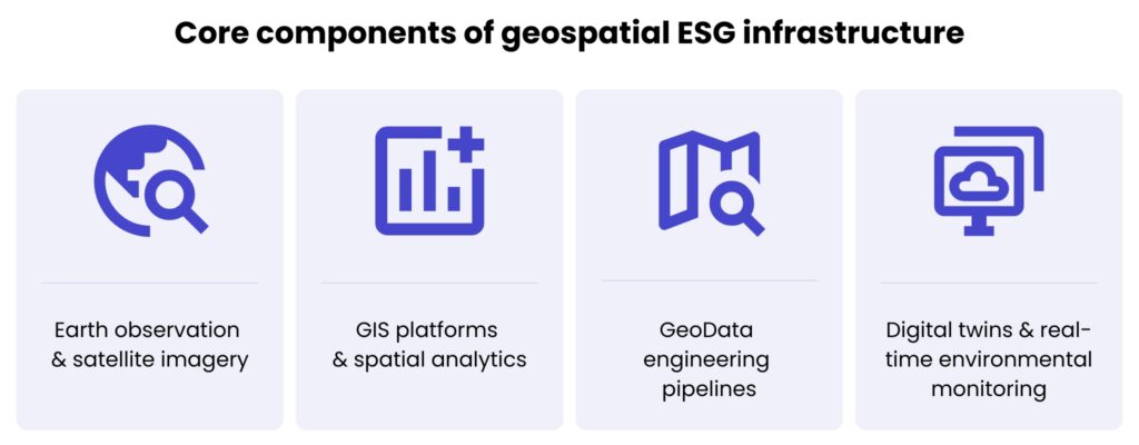
Observation de la Terre et imagerie satellitaire
Earth observation technologies provide organisations with continuous access to large-scale environmental data collected by satellites, drones and remote sensing systems. Satellite imagery allowes companies to monitor changes in land use, the health of vegetation, urban expansion, water availability, deforestation and environmental degradation over time.
Unlike traditional field-based assessments, satellite data enables consistent and repeatable monitoring across vast geographic areas. Satellite data is therefore particularly valuable for ESG reporting, where organisations increasingly need measurable and traceable evidence to support sustainability claims and environmental disclosures.
Plateformes SIG et analyses spatiales
GIS platforms have evolved into enterprise-scale analytical environments that can integrate environmental, operational and business data into a unified spatial context. Spatial analytics enables organisations to identify the relationships between environmental conditions and business operations.Instead of functioning as standalone mapping systems, GIS platforms are increasingly being used as decision support tools that connect sustainability objectives with operational realities.
Pipelines d'ingénierie GeoData
As volumes of ESG data continue to grow, organisations require scalable data engineering capabilities that can process and govern large amounts of spatial information. GeoData engineering involves building pipelines that integrate data from various sources, such as satellite imagery, IoT sensors, enterprise systems, public environmental databases, and climate models.
Ces pipelines gèrent l'ingestion, la transformation, la standardisation, le stockage et le traitement en temps réel des données, garantissant que les informations environnementales restent fiables, traçables et prêtes pour les rapports ESG, l'analyse et les audits de conformité.
Jumeaux numériques et surveillance environnementale en temps réel
Dans le contexte de l'ESG, jumeaux numériques permettre aux organisations de simuler environnemental scénarios, surveiller les performances des infrastructures et évaluer les risques climatiques en temps réel. Lorsqu'ils sont combinés à des dispositifs IoT, à des technologies de télédétection et à des analyses IA, ils soutiennent une surveillance environnementale continue plutôt que des cycles de reporting statiques.
Cela permet aux organisations de suivre la qualité de l'air, la consommation d'eau, la consommation d'énergie, l'exposition aux inondations et les changements écosystémiques en temps quasi réel, facilitant une prise de décision plus rapide et une gestion de la durabilité plus proactive.
Types dedonnées spatiales utilisé dans l’ESG
- Données d'occupation et de couverture des sols – Ces ensembles de données aident les organisations à surveiller l'évolution des environnements naturels et urbains au fil du temps. Ils sont largement utilisés pour suivre la déforestation, analyser l'expansion urbaine, planifier des projets d'énergie renouvelable et évaluer la biodiversité.
- Données sur les émissions et la qualité de l'air – Spatial emissions datasets enable organisations to identify pollution hotspots, monitor industrial emissions and analyse carbon intensity across geographic regions. Air quality monitoring systems combine satellite observations, IoT sensors, and atmospheric models to provide continuous environmental insights.
- Indicateurs de stress hydrique et de risque d'inondation – Climate-related risks like droughts, floods water scarcity are inherently location-specific. Spatial datasets assist with the identification of vulnerable assets, the assessment of infrastructure resilience, and the evaluation of long-term environmental risks associated with changing climate conditions.
- Cartographie de la biodiversité et des habitats – Biodiversity reporting is becoming an increasingly important part of ESG strategies and emerging regulatory frameworks. Geospatial technologies allow organisations to monitor ecosystems, identify habitat fragmentation, track changes in vegetation and evaluate proximity to protected areas.
- Intelligence de localisation pour la chaîne d'approvisionnement et la logistique – Modern supply chains generate vast amounts of location-based operational data. Geospatial analytics enables organisations to improve supply-chain transparency, assess environmental exposure across suppliers, optimise logistics routes and evaluate sustainability risks associated with geographic regions. As ESG requirements for supply chains continue to grow, location intelligence is becoming essential for understanding how environmental, regulatory and climate-related risks spread across global operations.
Cas d'usage ESG géospatiaux dans tous les secteurs
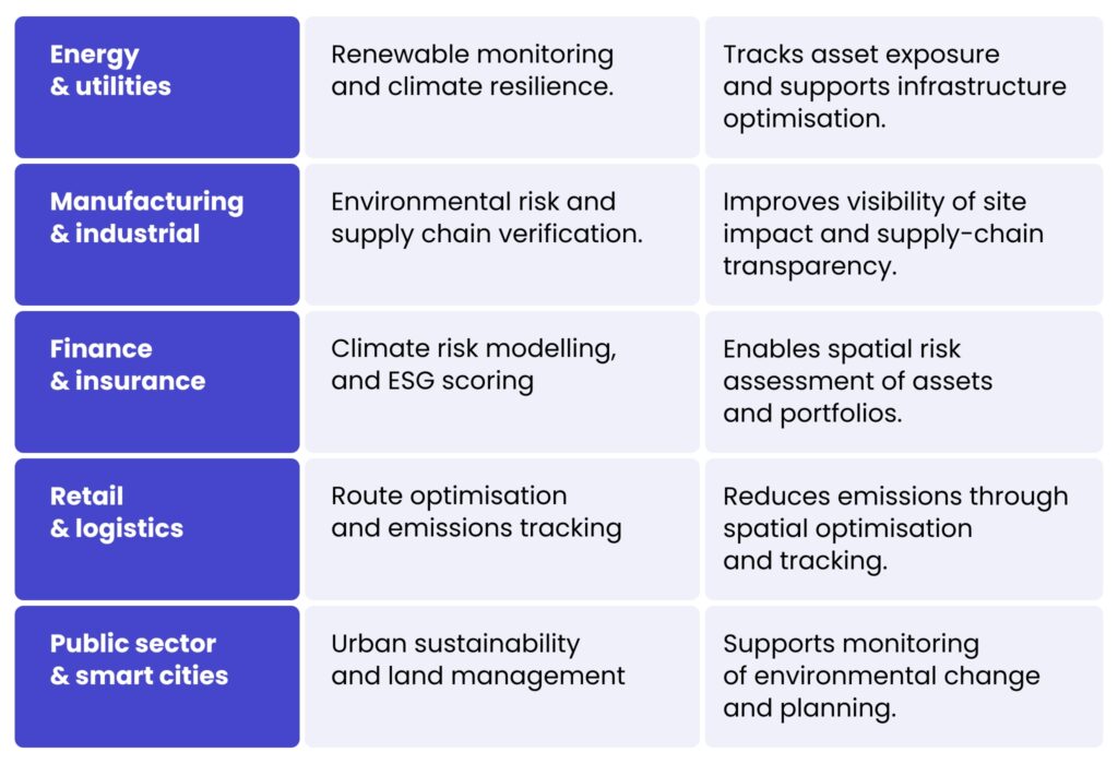
Domaines clés de l'ESG géospatial
Suivi de la biodiversité
Biodiversity is becoming a key pillar of ESG reporting, evolving from a qualitative sustainability issue into a quantifiable and verifiable aspect of corporate responsibility. This change is being driven by an increasing amount of regulation around nature-related disclosures, as well as growing pressure from investors and stakeholders to understand the impact of business activities on ecosystems. Frameworks such as the Taskforce on Nature-related Financial Disclosures (TNFD) are accelerating this transition by introducing structured approaches to assessing biodiversity risk and holding companies accountable for their environmental impact.
Les technologies géospatiales sont essentielles pour rendre la biodiversité mesurable à grande échelle, elles incluent :
- Observation des écosystèmes par satellite (santé de la végétation, changement d'affectation des sols, dégradation des écosystèmes)
- Analyse de la fragmentation des habitats (impact des infrastructures, de l'agriculture et de l'expansion urbaine)
- Surveillance spatiale à long terme du changement environnemental au fil du temps
Parallèlement, GeoAI transforme l'intelligence de la biodiversité en :
- Détecter automatiquement les schémas et anomalies écologiques,
- Classer la couverture terrestre à grande échelle à l'aide de données satellitaires et de capteurs,
- Permettre une analytique environnementale prédictive afin d'anticiper les risques pour la biodiversité.
Analyse des risques climatiques
As climate risk is inherently spatial, geospatial intelligence is a critical tool for understanding and managing its impact on business operations. Physical climate risk mapping allows organisations to evaluate their exposure to floods, droughts, heatwaves, and wildfires at a highly detailed, location-specific level. This offers far greater precision than traditional, aggregated risk models. Geospatial analytics also supports the assessment of infrastructure vulnerability by linking environmental hazards to operational assets, such as factories, energy facilities, logistics hubs and transport networks. This enables more accurate risk prioritisation. Scenario modelling and predictive analytics further enhance this capability by simulating future environmental conditions and forecasting potential impacts under different climate trajectories. Consequently, geospatial intelligence is being used increasingly to support business continuity and ESG resilience strategies, helping organisations to improve preparedness, reduce disruption and make more informed long-term investment decisions.
ingénierie GeoData
As Environmental, Social and Governance reporting increasingly relies on data and audits, organisations are finding it more challenging to manage fragmented and diverse environmental datasets from satellites, IoT devices, enterprise systems and external climate databases.
GeoData Engineering répond à cette complexité en construisant des pipelines de données géospatiales évolutifs qui :
- Ingérer et intégrer des données environnementales multi-sources,
- Standardiser et harmoniser les ensembles de données incohérents,
- Permettre le stockage cloud-native et le traitement en temps réel,
- Soutenir la surveillance et le reporting ESG continus.
Simultaneously, governance and compliance requirements are becoming increasingly important. The GDPR and the EU AI Act, for example, introduce strict rules regarding the usage of location data, transparency, and the explainability of AI. Therefore, ensuring strong data lineage and full traceability of ESG metrics is essential, as audit readiness is a fundamental requirement for credible, regulation-compliant sustainability reporting, rather than an optional extra.
Conclusion
À mesure que les réglementations renforcent les exigences de transparence, d'auditabilité et de qualité des données, les organisations ont besoin d'informations vérifiables et géolocalisées qui relient directement l'impact environnemental aux actifs physiques, aux opérations et aux chaînes d'approvisionnement.
By integrating Earth observation, geographic information systems platforms, geodata engineering and emerging geospatial artificial intelligence capabilities, businesses can report on and actively manage their sustainability performance. With the help of geospatial technologies they are able to leverage ESG to operate as a dynamic, data-driven system,, facilitating everything from biodiversity monitoring and climate risk modelling to emissions tracking and supply-chain transparency.
The maturity of Environmental, Social and Governance practices accelerates organisations that invest in scalable geospatial infrastructure will be better positioned to meet regulatory expectations, reduce environmental risk, and build long-term resilience.
À vous de jouer
Si vous envisagez de développer ou d'étendre vos capacités géospatiales pour le reporting ESG, la conformité ou la gestion des risques climatiques, nos experts sont prêts à vous accompagner dans la conception et la mise en œuvre de solutions complètes.
Utilisez le formulaire de contact ci-dessous pour échanger avec nos spécialistes et découvrir comment les technologies géospatiales pourraient renforcer votre stratégie et vos résultats.
Geospatial data provides verifiable, location-based evidence to help organisations measure environmental impacts, such as land use, emissions, biodiversity and climate risks. With regulations such as the CSRD and EU Taxonomy demanding greater transparency and auditability, spatial intelligence has become an essential component of reliable ESG reporting.
GeoData Engineering enables organisations to collect, integrate, standardise, and process large volumes of environmental data from sources such as satellites, IoT devices, and enterprise systems. This creates reliable, scalable data pipelines that support continuous ESG monitoring, regulatory compliance, and audit-ready reporting.
Geospatial technologies allow organisations to monitor ecosystems, assess habitat changes, model climate risks, and identify environmental threats in near real time. This helps businesses make informed decisions, reduce environmental risks, and support long-term sustainability strategies with measurable evidence.
Industries including energy, manufacturing, finance, retail, logistics, and the public sector use geospatial technologies to monitor environmental performance, optimise operations, and strengthen ESG compliance. Applications range from renewable energy monitoring and emissions tracking to supply-chain transparency and climate risk assessment.


arrow_circle_rightnous contacter
Contactez-nous pour découvrir comment nos experts peuvent soutenir votre projet

arrow_circle_right notre blog