مزايا المحولات في التعرف الآلي على المباني


The development of automated detection technologies has opened new possibilities for analysing urban spaces with speed, accuracy and cost-effectiveness. Advanced technologies combined with transformer models such as Real-Time DEtection TRansformers are taking the field of Geo AI إلى الأمام، مما يتيح التعرف الآلي الفوري على المباني وتحديدها بدقة في الصور الساتلية أو الجوية.
هناك اتجاه متزايد في التحليلات الجغرافية المكانية المدعومة بالذكاء الاصطناعي، حيث تعلم الآلة تعمل النماذج على تحسين سير العمل المكاني من خلال أتمتة استخراج البيانات and improving accuracy in high-stakes projects. As technology advances, recognition models promise to improve operational outcomes across various domains, demonstrating AI’s transformative potential in المعلومات الجغرافية المكانية التطبيقات.
In this article, we introduce how transformers are revolutionising geospatial analysis with real-time detection, improved accuracy, and significant cost savings, as well as its applications in various industries and its important role in the automated building recognition project.
ما هي المحولات وكيف تعمل؟
Transformers are a neural network architecture designed to process sequences, such as text, by understanding the context and relationships within the data. They can handle long-range dependencies, making them highly effective for tasks such as معالجة اللغة الطبيعية (NLP). Transformers work through two key innovations. The first is self-attention, a mechanism that evaluates how different parts of a sequence relate to each other, allowing the model to capture dependencies across the input. The second is parallel processing, which allows the analysis of entire sequences simultaneously rather than step-by-step.
من خلال الجمع بين الفهم السياقي مع قابلية التوسع, transformers have become central to advances in modern AI, extending their impact beyond NLP to areas such as vision and geospatial analysis. For example, Vision Transformers (ViTs) leverage the transformer architecture to process image data by breaking it into patches, analysing relationships between patches, and excelling at tasks like image classification, object detection, and segmentation.
اطّلع على عروضنا في مجال المعلومات الجغرافية المكانية
اكتشف المزيد
ماذا عن RT-DETR؟
محوّل الكشف في الوقت الفعلي is an advanced machine learning model designed for fast and accurate object detection. It uses transformer-based neural networks to process visual data in parallel, making it ideal for real-time applications such as detecting and outlining buildings in urban areas. By exploiting attention mechanisms, RT-DETR focuses on relevant image details and efficiently identifies objects and their contours, even in dense or cluttered scenes. This family of models eliminates the need for costly Non-Maximum Suppression usage, which negatively affects popular alternatives, such as YOLO models. RT-DETR often outperforms YOLO models of similar size. This technology is perfect for applications that require accurate, real-time object recognition.
كيف تختلف المحوّلات عن معماريات الشبكات العصبية الأخرى
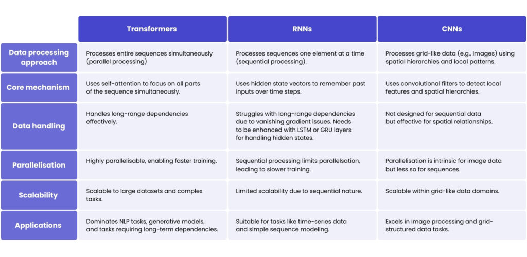
Think of a traffic control tower equipped with radar systems that can instantly monitor all airplanes in the sky, regardless of their distance. The control tower doesn’t need to watch planes in the order they take off or land. Instead, it has a complete bird’s-eye view, identifying patterns and connections across the entire airspace at once. This is how المحولات العمل. يقومون بمعالجة جميع بيانات الإدخال في وقت واحد and use attention mechanisms to focus on the most relevant parts of the data. For example, they can identify that “plane A,” which took off an hour ago, is relevant to “plane B,” landing now, without needing to process every flight in between.
Now, picture an air traffic controller who has to watch planes take off and land one by one in a strict sequence. To understand what’s happening, they must recall what they saw earlier – building context as they go. For instance, if they saw “plane C” land earlier, they use that memory to decide whether to clear “plane D” for takeoff. This is the way the الشبكات العصبية المتكررة (RNNs) وظيفة. فهي تعالج البيانات بشكل تسلسلي، خطوة بخطوة، وتعد رائعة لمهام مثل التنبؤ بالكلمة التالية في جملة أو تحليل السلاسل الزمنية، حيث يكون السياق السابق ضرورياً.
لفهم كيفية الشبكات العصبية الالتفافية (CNNs) work, imagine scanners placed along airport runways that analyse each section of a plane as it passes. These scanners only look at small sections at a time, but together they form a complete picture of the plane’s condition. They’re great for checking localised details, like whether the plane’s landing gear is down, or its engines are working properly, and for visual tasks, such as identifying objects in an image.
تطبيقات RT-DETR في التحليل الجغرافي المكاني
This technology has a major impact on many industries where geospatial analysis is essential, streamlining processes through its ability to deliver accurate, real-time data. Here are some of the industries where RT-DETR is beneficial, and how its capabilities meet the unique needs of each.
التخطيط العمراني وتطوير البنية التحتية
It aids urban planners and developers by quickly and accurately identifying buildings, roads and other urban features. RT-DETR supports monitoring urban growth, updating city maps, and optimising resource allocation. By identifying underutilised or high-demand areas, it enhances zoning decisions and infrastructure planning. The technology also assists in recognising non-structural elements like green spaces, car parks, and waterways for comprehensive urban development.
تقييم العقارات والممتلكات
Real estate companies and government agencies benefit from RT-DETR’s ability to automate the detection and measurement of built-up areas, roads, and landscape features like parks or water bodies. This ensures consistent, accurate data even in densely populated or complex environments, aiding in property assessment and valuation.
إدارة الكوارث والاستجابة للطوارئ
In emergencies, this advanced technology provides real-time recognition of buildings, roads, and natural barriers, which is critical for assessing vulnerability, planning evacuation routes, and deploying resources. RT-DETR can identify changes in the landscape caused by natural disasters, like flooded areas or collapsed structures, enabling quicker and more efficient response coordination.
الدفاع والأمان
It supports strategic planning by detecting changes in infrastructure, road networks, and other key features across regions. It is invaluable for border security operations, surveillance, and defence planning, helping to monitor urban growth, identify potential security threats, and optimise patrol routes.
المراقبة والحماية البيئية
RT-DETR plays an essential role in tracking changes in natural landscapes, such as deforestation, urban encroachment on protected areas, and habitat loss. Its ability to recognise features like rivers, vegetation cover, and artificial structures supports enforcement of environmental policies and aids in sustainable development. It also helps monitor the impact of human activity on ecosystems, ensuring informed conservation efforts.
محوّل الكشف في الوقت الفعلي في التعرف الآلي على المباني
Accurate building recognition is key to many urban planning and real estate applications, but accurately identifying buildings in large datasets can be challenging. One of our clients required a system that could efficiently recognise buildings and, ideally, generate an outline of each building – a feature rarely found in conventional recognition tools. Overcoming this challenge needed an advanced approach that could provide both fast recognition and accurate structural mapping.
To meet the client’s needs, we developed a robust building recognition system using Real-Time DRtection TRansformer technologies as the main recognition framework. We adapted the RT-DETR model to the building recognition task to increase accuracy and stability. To add value to the building outline generation, we integrated نموذج تجزئة أي شيء (SAM) لتوفير تقسيم دقيق وقابل للتوسع للمباني.
لتحسين الأداء على الصور الأكبر حجمًا واكتشاف الأجسام الصغيرة فيها، استفدنا من الرؤية الحاسوبية و الاستدلال الفائق بمساعدة التقسيم (SAHI)، مما زاد بشكل كبير من قدرات النظام عبر تقسيم البيانات المرئية وتمكين اكتشاف الأجسام الصغيرة دون إعادة تدريب مكثفة للنموذج.
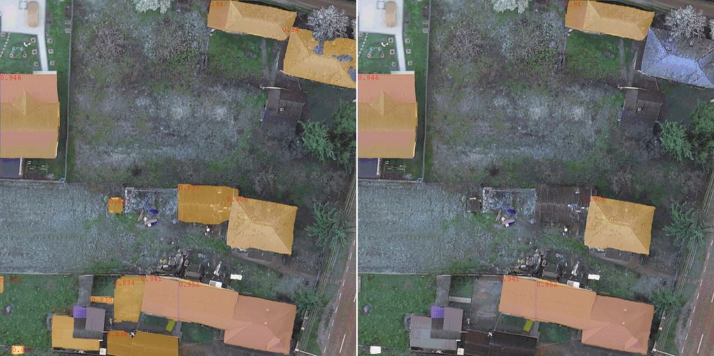
وخلاصة القول، يتكون الحل من 4 عناصر رئيسية:
1. تجزئة الصور – The process begins with SAHI, which divides the input image into smaller overlapping tiles using a sliding window technique. This provides better handling of large images and improved detection of small objects such as rooftops.
2. إنشاء الأقنعة – تتم معالجة كل بلاطة بعد ذلك بواسطة FastSAM، الذي يولد أقنعة تقسيم دقيقة للمباني المحتملة داخل كل شريحة.
3. التصنيف باستخدام RT-DETR المضبوط بدقة – The segmentation masks generated by FastSAM are then classified by a fine-tuned Real-Time Detection Transformer (RT-DETR) model, specifically trained on rooftop images, to ensure accurate detection and classification of building structures.
4. إعادة التجميع وتجميع الأقنعة – All processed slices and their corresponding segmentation masks are re-assembled into a coherent image. Overlapping areas are reconciled by aggregating the coloured masks, effectively creating a unified building outline that is both accurate and scalable.
After implementing the solution, the client received excellent results. The system accurately identifies buildings in real-time and can generate clear and detailed outlines. In addition, SAHI ensured that even small structures in large images could be identified without sacrificing processing speed. The solution improved operational efficiency and increased the accuracy of the client’s urban analysis data.
Integrating Real-Time DEtection TRansformer with advanced technologies such as SAHI and SAM has enabled us to address one of the biggest challenges in urban data analysis – scalable and accurate building detection. This solution gives our client a competitive advantage by combining speed with exceptional detail in real-time building outline generation.
بيوتر سيمبيريكي، كبير علماء بيانات الذكاء الاصطناعي في Spyrosoft
الفوائد الرئيسية لمحولات الكشف في الوقت الفعلي
كشف الأجسام بدقة عالية
RT-DETR uses transformers to focus on specific parts of the image, capturing detailed object outlines and complex shapes, resulting in improved accuracy, especially in complex clusters or scenes where precise boundaries are essential.
السرعة والكفاءة
RT-DETR models excel at processing large amounts of data quickly. They can perform fast object detection and image segmentation without significant latency using transformer attention mechanisms and parallel processing.
تقليل الحاجة إلى المعالجة اليدوية للبيانات
فهو يُؤتمت عملية تحديد الكائنات وتقسيمها، مما يوفّر الوقت والموارد ويتيح للمتخصصين ذوي الكفاءة التركيز على التحليل المتقدم والتخطيط الاستراتيجي.
المتانة
وهو يضمن نتائج موثوقة حتى في الظروف الديناميكية. على سبيل المثال، يتم تخفيف النتيجة الإيجابية الخاطئة في صورة واحدة في الصور اللاحقة، مما يقلّل من تأثيرها على دقة الكشف الإجمالية.
التنوع عبر القطاعات
The flexibility of RT-DETR makes it highly versatile and useful across various industries. Each sector can apply technology to meet its specific needs and improve the quality of decision-making with reliable and up-to-date spatial data.
طوّر تحليلك الجغرافي المكاني مع Spyrosoft
بفضل خبرتنا في الحلول الجيومكانية المتقدمة، يمكننا تكييف أحدث التقنيات مع الاحتياجات الفريدة لصناعتك، مما يساعدك على اتخاذ قرارات أسرع وأذكى وأكثر استنارة.
تواصل مع خبرائنا في التحليلات الجغرافية المكانية اليوم لمعرفة كيف يمكن للمحولات أن تغير مشاريعك وتمنحك ميزة تنافسية من خلال رؤى قابلة للتنفيذ وفي الوقت المناسب!
الأسئلة الشائعة: التعرف الآلي على المباني
Transformers are advanced deep learning architectures that excel at processing complex data patterns. In the context of building recognition, they facilitate the more accurate extraction of building footprints from satellite imagery by effectively capturing spatial relationships and contextual features across entire images.
Unlike CNNs, which focus on local features, Transformers use self-attention mechanisms to analyse global patterns within an image. This enables them to detect building shapes and boundaries more accurately, particularly in cluttered or complex urban environments.
Transformers offer enhanced accuracy, scalability and generalisation when processing satellite data. They perform well in different geographic regions and can be trained using large datasets to recognise various architectural patterns, thereby reducing the need for extensive manual labelling or rule-based systems.
Yes, although transformers offer high levels of accuracy, they demand substantial computational resources and extensive annotated datasets for effective training. Furthermore, achieving optimal performance while maintaining precision across different environments can be complex and time-consuming.
These models support a variety of applications, including urban planning, disaster response, infrastructure monitoring and updating maps. Automated, accurate building detection enables governments, engineers and geospatial analysts to make informed decisions quickly and efficiently.


arrow_circle_rightاتصل بنا
تواصل معنا للتحقق من كيفية دعم خبرائنا لمشروعك

arrow_circle_right مقالاتنا