Innovations technologiques dans les solutions logicielles géospatiales et leur impact sur la croissance rapide du secteur


In recent years, the geospatial field has witnessed immense growth, fuelled by richer and more precise data and cutting-edge advancements in the digital realm. Constantly emerging technological novelties are continuously contributing to the creation of better-performing and more accessible geospatial software solutions. Consequently, the sector has also begun to play a greater role in developing and supporting other industries.
Dans cet article, nous nous appuyons sur l'expérience de nos experts – Jaroslaw Marciniak (Directeur deServices géospatiaux) et Andrew Radcliffe (Directeur Général de Spyrosoft UK), pour aborder le thème de l'ingénierie logicielle et de la technologie dans le secteur géospatial et découvrir les opportunités qu'elles peuvent apporter à différentes entreprises.
Un regard sur le secteur géospatial
Globally, the geospatial industry is growing rapidly. Lately, it has been shifting away from a product-centric approach and focusing on being solutions-oriented with a strong emphasis on IT technologies and engineering. Moreover, advanced geospatial analytics has become integral to various sectors such as archaeology, disaster response, urban planning, infrastructure, logistics, transport and retail.
Dans cette optique, la prédiction donnée dans le Rapport GEOBUIZ 2022 that the global geospatial market will reach a staggering USD 681 billion by 2025 should come as no surprise. The current growth of the sector is primarily driven by physical technology innovation. With a 45% market share, GNSS & Positioning hardware is predicted to be the most popular and fastest-growing geospatial tech category. It is followed by GIS & Spatial Analytics at 25% and Earth Observation at 17%.
Tirer parti des solutions logicielles géospatiales
Significant innovation opportunities for the market are also offered by software solutions that use location-based data. Workflow integration, image analysis and the extension of spatial analytics into business processes are also important factors contributing to market growth. All of these opportunities pave the way for new geospatial software solutions that utilise location data in various areas, including infrastructure, transport, housing, environment, public health, emergency response, ocean economy, retail and finance.
Fournisseurs de services géospatiaux professionnels
Compte tenu de l'expansion rapide du secteur et de son potentiel à bénéficier à de multiples domaines, il est crucial d'explorer le marché des prestataires professionnels de services géospatiaux. Ces entreprises peuvent être classées comme suit :
- Cabinets de conseil – qui disposent généralement d'experts du domaine au sein de leur personnel, offrant des conseils et des orientations professionnels ainsi que des solutions pratiques.
- Fournisseurs de logiciels SIG – qui produisent principalement des logiciels offrant des outils d'analyse géospatiale et des solutions connectées aux SIG.
- Entreprises de solutions technologiques – qui fournissent des solutions matérielles généralement utilisées pour la cartographie aérienne, les SIG/GNSS, les UAV/drones, la numérisation laser, le LiDAR, et plus encore.
- Organisations d'ingénierie logicielle et de plateformes génériques – qui proposent des solutions logicielles géospatiales sans avoir une compréhension approfondie du secteur, de ses normes et des nuances de sujets tels que le traitement des données raster, les projections, les systèmes de référence ou les diverses sources de données.
For optimal results in a geospatial project, it is advisable to work with companies that specialise in several areas simultaneously. The blending and parallel incorporation of aspects like industry expertise, domain knowledge, technical know-how, advisory services, and business outlook enables a project’s end-to-end coverage and thereby facilitates its completion.

Tendances technologiques dans le géospatial
The significance of technology in the geospatial industry cannot be overlooked. Innovations in this field can address socio-economic challenges and promote sustainable practices. The use of modern geospatial software solutions can significantly facilitate understanding of some pressing problems and help find answers to them.
Selon le rapport « Enquête 2023 auprès des PDG et des cadres dirigeants«, la technologie qui mènera l'innovation est l'IA. Elle sera suivie par la digitalisation, l'automatisation, l'analyse de données et le cloud computing, qui impacteront significativement de multiples industries dans les années à venir.
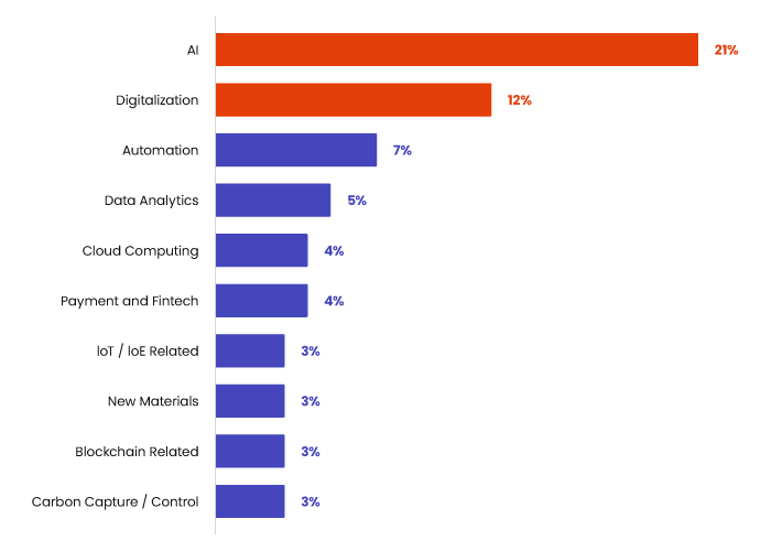
Source : Enquête 2023 auprès des PDG et cadres dirigeants de Gartner
Toutes les technologies mentionnées peuvent être utilisées dans des solutions logicielles géospatiales spécifiques à un domaine. Concernant les principales technologies listées ci-dessus, les exemples d'application incluent :
AI
- Extraction automatisée de caractéristiques
- Attribution automatisée des caractéristiques
- Détection et classification d'objets
Numérisation
- Jumeaux numériques – modèles d'objets du monde réel
- Algorithmes de super-résolution
- Généralisation automatisée
Automatisation des processus
- Solutions RPA/Low-code/No-code
- Pratiques DevOps et IaaC
Analyse de données
- Traitement de nuages de points
- Harmonisation des données
- Analyse spatiale
- Analyse prédictive des données
- Analyse spatio-temporelle
Informatique en nuage
- Cloud-native
- Informatique en périphérie
- Optimisation des coûts cloud
The Gartner survey also demonstrates that IT functions in businesses should fuel innovation, digital transformation, and front-end experience, which are key activities often strongly linked to business development itself. It is an easily noticeable industry change in which we see IT operations becoming one of the most important centres of growth and innovation, not just a cost centre.
Créer des avantages grâce à la technologie et à l'ingénierie logicielle
At Spyrosoft, we combine technological expertise, domain knowledge, and consultancy skills to help our clients gain digital and business advantages. Our track record includes successful projects involving mobile and web online mapping platforms, backend improvements and incorporating cutting-edge des solutions logicielles géospatiales qui utilisent des technologies telles que l'IA et AR/MR.
Apart from that, we meet clients’ needs by designing and implementing data platforms from scratch or conducting integrations with already existing systems. When creating projects, we use microservices-based architecture, UI/UX, agile methodologies and AWS geospatial cloud services.
À vous de jouer
Explorez notre large éventail de projets et découvrez comment les experts de Spyrosoft peuvent aider votre entreprise à développer des solutions logicielles géospatiales supérieures.
Visitez notre page d'offre pour plus de détails, ou contactez-nous via le formulaire de contact ci-dessous.


arrow_circle_rightContactez-nous
Contactez-nous et découvrez comment nous pouvons vous aider

arrow_circle_right Nos articles


