دور هندسة البيانات المكانية في الإدارة الحديثة للأراضي


Land development relies on precise, data-driven decision-making, in which geospatial engineering plays a critical role. By integrating geospatial data from multiple sources, from high-resolution satellite imagery and LiDAR scans to IoT sensor networks, developers can optimise site selection, infrastructure planning and risk assessment with unprecedented accuracy.
Advanced geospatial analytics, powered by AI and cloud computing, enable real-time processing of massive datasets, improving predictive modelling for environmental impact, urban mobility and resource allocation.
In this article, we’ll explore what spatial data engineering is, how it’s changing land management, and the tangible benefits it offers. We’ll also present real-world case studies from our own portfolio to illustrate its practical impact and share what we’ve learned along the way.
المكونات الرئيسية لهندسة البيانات المكانية في تطوير الأراضي
Modern land management demands a comprehensive approach to managing spatial data, from collection to analysis. Spatial data engineering is the foundation of this process, enabling seamless integration, efficient processing and actionable insights.
الحصول على البيانات وتكاملها
يعتمد تطوير الأراضي الحديث على مصادر بيانات متنوعة لبناء نماذج جغرافية مكانية دقيقة، بما في ذلك:
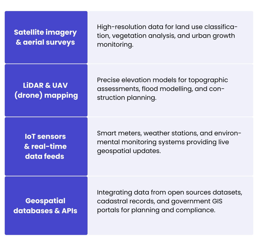
Integrating these heterogeneous datasets requires data pipelines, typically built with a spatial ETL platform like FME (Feature Manipulation Engine), and adherence to interoperability standards such as OGC Web Services (WMS/WFS).
معالجة البيانات وتحويلها
بمجرد الحصول على البيانات الجغرافية المكانية الخام، يجب هيكلتها وتحسينها للتحليل. تتضمن العمليات الرئيسية:
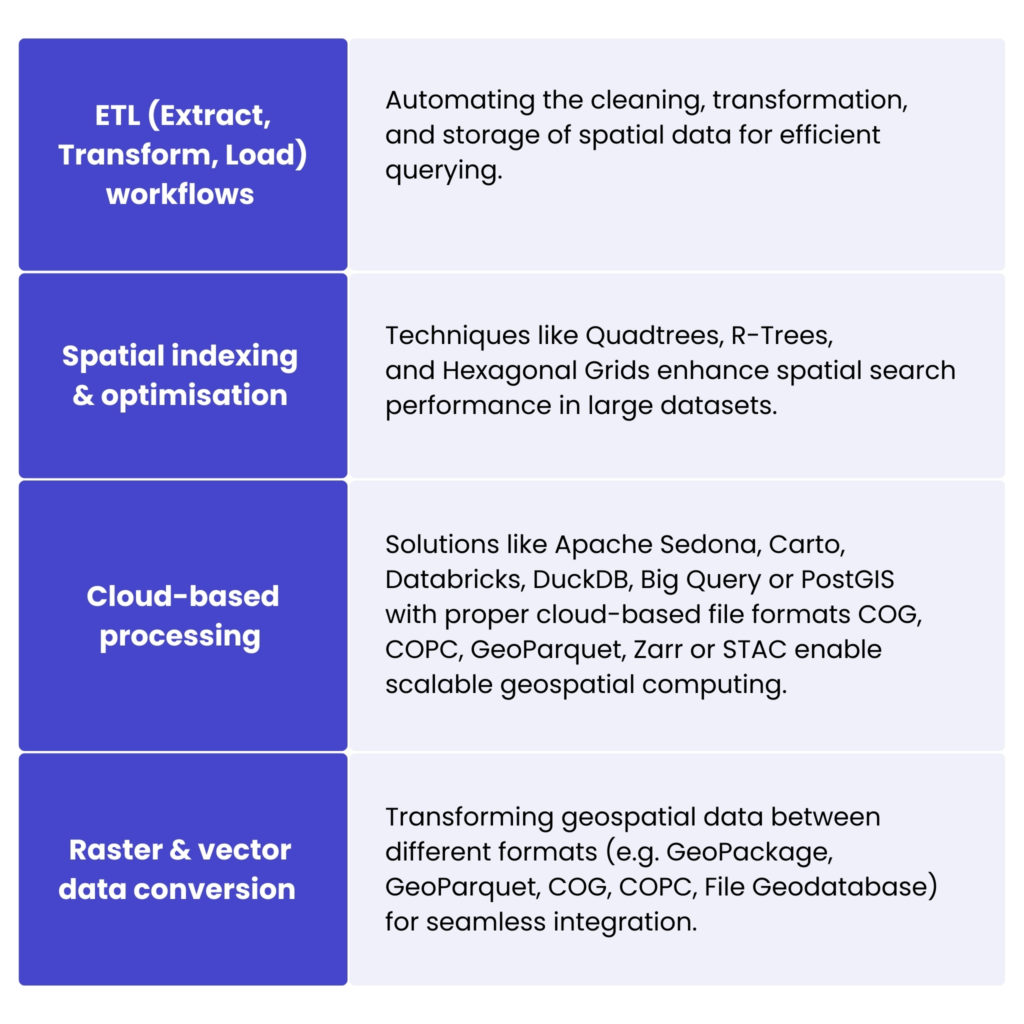
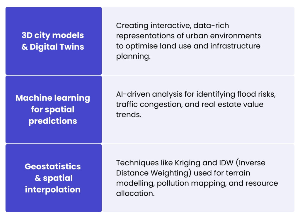
النمذجة والتحليلات للبيانات المكانية
تعزز تقنيات النمذجة المتقدمة اتخاذ القرارات في إدارة الأراضي من خلال محاكاة الظروف الواقعية، مثل:
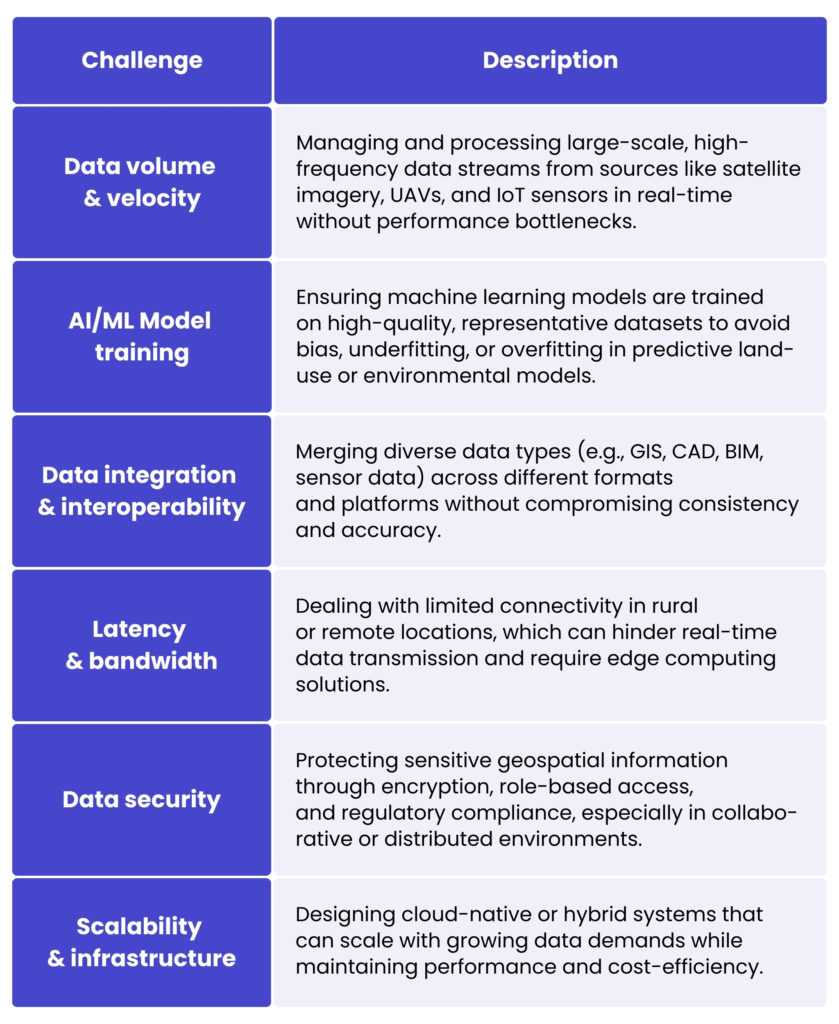
التحديات التقنية الأساسية في الهندسة المكانية
Spatial data engineering offers many opportunities in the field of planning and spatial management, but its operational implementation poses significant technological challenges. Many organisations still lack the necessary technological and process skills to fully exploit the potential of geospatial data in land development projects.
For the UK’s largest gazetteer, GeoPlace, we addressed a key GIS challenge focused on improving data analysis and import processes. The client needed to improve the efficiency and scalability of handling large datasets from multiple sources.
Our solution centralised all files in one location for easier analysis and introduced a notification system to alert users when action was required, streamlining the workflow. We also enhanced the client’s code review processes, improving efficiency and readability for better long-term maintenance. GeoPlace’s infrastructure is built on Oracle technologies, including Oracle Private Cloud و افتراضي أجهزة تُدار بواسطة VMware. Their setup includes an Oracle 12.2 cluster with Active Data Guard for data protection, and a separate cluster for web applications and storage managed by Ceph Block. It also uses Saltstack, Ansible, Kubernetes and Docker for configuration management and container orchestration.
باستخدام هذا الحل، حسّنت GeoPlace قدراتها في معالجة بيانات نظم المعلومات الجغرافية، ومهّدت الطريق لقابلية التوسع المستقبلية، وقدّمت بنية تحتية أكثر كفاءة وموثوقية.
اطّلع على عرضنا في الجغرافيا المكانية
اقرأ المزيد
التطبيقات الجغرافية المكانية في إدارة الأراضي
Spatial data engineering is transforming how land is monitored, allocated, and developed by enabling more precise, data-driven decision making. Here we look at some of its most impactful applications in modern land management:
- إدارة السجل العقاري والممتلكات – enables the creation and maintenance of digital cadastral systems, which are fundamental to determining property boundaries, ownership rights and tax values. Using technologies such as GPS surveying, LiDAR and automated boundary detection, cadastral data can be updated with unprecedented accuracy and efficiency, improving legal clarity, reducing land disputes and facilitating seamless integration with national land registries and e-government services.
- التخطيط العمراني وتقسيم المناطق – planners are using geospatial engineering to design sustainable, resilient cities. By integrating land use data with demographic, economic and environmental layers, engineers can create intelligent zoning models and simulate future development scenarios. 3D city models, change detection algorithms and spatial optimisation techniques help authorities identify unauthorised construction, assess land use efficiency and plan infrastructure expansion with minimal environmental impact.
- تحسين استخدام الأراضي الزراعية – allows precision farming by analysing soil characteristics, weather patterns and vegetation health at high resolution. Remote sensing and IoT-based monitoring systems help optimise crop placement, irrigation and fertiliser use. Land suitability maps and predictive yield models help policymakers and farmers maximise land productivity while minimising environmental impact.
- المراقبة البيئية – specialists use satellite imagery, drone data and machine learning models to detect changes in land cover, deforestation patterns, soil degradation and water body fluctuations. The results support proactive land conservation efforts, enforce environmental regulations, and guide sustainable land-use planning in vulnerable areas.
- تخطيط البنية التحتية والمرافق – by combining topographic, geotechnical and regulatory data, spatial engineers can identify optimal routes and avoid environmentally or legally sensitive areas, reducing project delays, cost overruns and environmental impacts, and ensuring that infrastructure development is consistent with long-term land use strategies.
تبسيط إدارة الأراضي من خلال منصة رسم خرائط تعاونية
Land App هي منصة رسم خرائط تعاونية عبر الإنترنت بديهية، مصممة لمساعدة المستخدمين على تخطيط وتصميم وإدارة المشاريع القائمة على الأراضي بسهولة. طُوّرت بالتعاون مع Ordnance Survey، it brings together all stakeholders in the rural sector, landowners, agencies and consultants on a single, interactive digital map. The platform is fully compliant with UK legislation and tailored to the specific needs of both professional land agencies and individual users.
Our Spyrosoft team was brought on board to take full responsibility for the technical development of the platform, including the ongoing maintenance of the core map-builder web application. The primary objective was to ensure that users could independently produce detailed, compliant maps of selected land areas based on step-by-step guidance. These maps often form part of investment registration and land management documentation for both private and public projects.
Our responsibilities span the entire IT lifecycle, from architectural design and infrastructure deployment to feature development and long-term maintenance. As part of this work, our engineers have delivered an enterprise-level user management module and introduced a range of advanced tools to enhance the map editing experience.
>> اقرأ المزيد عن دراسة حالة Land App
الفوائد الرئيسية لهندسة البيانات المكانية المتكاملة
تكامل البيانات عالي الدقة
Spatial data engineering enables the fusion of heterogeneous data sets (e.g. satellite imagery, UAV-collected LiDAR, cadastral data and sensor feeds) into unified spatial databases. Through integration, it supports more accurate geospatial modelling and provides a foundation for consistent decision making across departments and systems.
سير عمل جيومكاني آلي
By implementing data pipelines and geospatial ETL tools, routine processes such as parcel updates, zoning changes and topographic analysis can be fully automated, what drastically reduces manual effort, minimizes errors, and ensures that data remains current and actionable.
المعالجة الجغرافية المكانية القابلة للتوسع
استخدام منصات الحوسبة الموزعة والخدمات السحابية الممكّنة جيومكانيًا (مثلPostGIS أو GeoMesa أو Google Earth Engine)، تتيح الهندسة الجيومكانية إجراء تحليلات جيومكانية معقدة، مثل نمذجة الملاءمة أو كشف التغييرات، على مجموعات بيانات ضخمة في الوقت شبه الفعلي.
الاستعلام والفهرسة المكانية المتقدمة
من خلال الفهرسة المكانية المُحسَّنة (على سبيل المثال R-trees، QuadTrees) and the use of geospatial databases, engineers can perform high-speed spatial joins, proximity analysis and geofencing operations with millisecond latency, essential for real-time monitoring applications in land use and infrastructure planning.
قابلية التشغيل البيني والتوحيد القياسي
تفرض هندسة البيانات المكانية معايير البيانات (على سبيل المثال تنسيقات متوافقة مع OGC مثل OGC API وGeoJSON وWMS/WFS وGML) and ensures that geospatial systems, from GIS platforms to digital twins, are able to exchange data seamlessly. The interoperability is key for multi-stakeholder collaboration on land management projects across government, environmental, and commercial sectors.
Collectively, these capabilities enable land managers, urban planners, and environmental scientists to work with greater data fidelity, operational efficiency, and predictive foresight, ultimately leading to more informed and sustainable land use decisions.
الخلاصة
As land management becomes increasingly data-driven, spatial data engineering stands out as a game changer. It brings together high-resolution data, real-time insights and scalable cloud infrastructure to enable smarter, more sustainable movements. With its ability to automate workflows and enable cross-sector collaboration, it’s laying the groundwork for advanced land development strategies.
If you’re looking to consult on your land management practices, our geospatial experts are ready to help. Get in touch by filling in the form below and explore what’s possible with geospatial engineering.
الأسئلة الشائعة: هندسة البيانات المكانية
Land development requires precise site selection, infrastructure planning and risk assessment. Spatial data engineering enables developers to combine multiple datasets into a single, reliable view, improving accuracy, reducing uncertainty and supporting sustainable decision-making.
تشمل مصادر البيانات الشائعة:
– صور الأقمار الصناعية والصور الجوية عالية الدقة
– عمليات مسح LiDAR
– بيانات المسح باستخدام GPS
– سجلات المسح العقاري والسجل العقاري
– شبكات استشعار إنترنت الأشياء
– مجموعات البيانات البيئية والديموغرافية
يتيح دمج هذه المجموعات المتنوعة من البيانات إجراء تحليل مكاني شامل.
Integration is typically achieved through spatial ETL (Extract, Transform, Load) tools such as FME and by following interoperability standards like OGC Web Services (WMS/WFS). These tools ensure that data from different formats and systems can work together seamlessly.
It enables the creation and maintenance of accurate digital cadastral systems. Using technologies like GPS surveying, LiDAR and automated boundary detection, property boundaries and ownership records can be updated more efficiently, reducing disputes and improving integration with land registries.
Urban planners use spatial data engineering to integrate land use, demographic and environmental data into predictive models. Tools such as 3D city models and change-detection algorithms help assess infrastructure needs, monitor unauthorised construction and plan sustainable city expansion.
It supports precision farming by analysing soil data, weather patterns and vegetation health. Remote sensing and IoT monitoring systems help optimise irrigation, fertiliser use and crop placement, improving productivity while reducing environmental impact.


arrow_circle_rightاتصل بنا
لنناقش كيف يمكننا دفع مشروعك إلى الأمام

arrow_circle_right مقالاتنا