Le rôle de l'ingénierie des données spatiales dans la gestion moderne du territoire


Land development relies on precise, data-driven decision-making, in which geospatial engineering plays a critical role. By integrating geospatial data from multiple sources, from high-resolution satellite imagery and LiDAR scans to IoT sensor networks, developers can optimise site selection, infrastructure planning and risk assessment with unprecedented accuracy.
L'analyse géospatiale avancée, propulsée par l'IA et l'informatique en nuage, permet le traitement en temps réel de volumes massifs de données, améliorant la modélisation prédictive pour l'impact environnemental, la mobilité urbaine et l'allocation des ressources.
In this article, we’ll explore what spatial data engineering is, how it’s changing land management, and the tangible benefits it offers. We’ll also present real-world case studies from our own portfolio to illustrate its practical impact and share what we’ve learned along the way.
Composants clés de l'ingénierie des données spatiales dans l'aménagement du territoire
La gestion moderne du territoire exige une approche globale de la gestion des données spatiales, de la collecte à l'analyse. L'ingénierie des données spatiales constitue le fondement de ce processus, permettant une intégration transparente, un traitement efficace et des insights exploitables.
Acquisition et intégration des données
Le développement foncier moderne dépend de diverses sources de données pour construire des modèles géospatiaux précis, notamment :
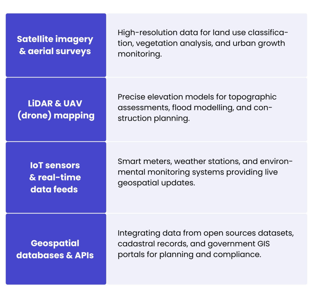
L'intégration de ces ensembles de données hétérogènes nécessite des pipelines de données, généralement construits avec une plateforme ETL spatiale comme FME (Feature Manipulation Engine), et le respect de normes d'interopérabilité telles que les services web OGC (WMS/WFS).
Traitement et transformation des données
Une fois acquises, les données géospatiales brutes doivent être structurées et optimisées pour l'analyse. Les processus clés comprennent :
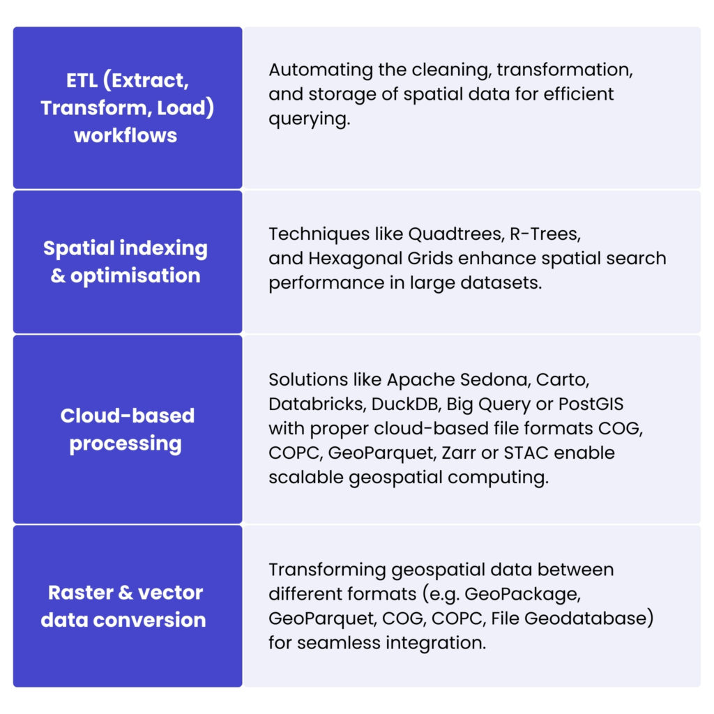
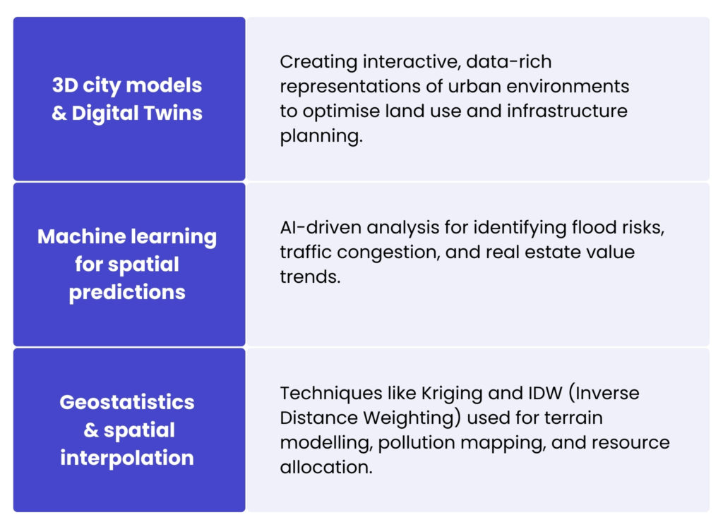
Modélisation et analyse des données spatiales
Les techniques de modélisation avancées améliorent la prise de décision en gestion foncière en simulant des conditions réelles, par exemple :
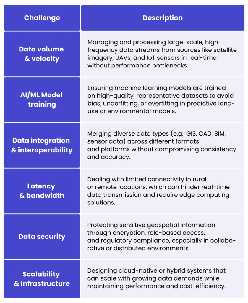
Principaux défis techniques de l'ingénierie spatiale
Spatial data engineering offers many opportunities in the field of planning and spatial management, but its operational implementation poses significant technological challenges. Many organisations still lack the necessary technological and process skills to fully exploit the potential of geospatial data in land development projects.
Pour le plus grand gazetteer du Royaume-Uni, GeoPlace, nous avons relevé un défi SIG majeur axé sur l'amélioration de l'analyse des données et des processus d'importation. Le client avait besoin d'améliorer l'efficacité et l'évolutivité du traitement de grands ensembles de données provenant de sources multiples.
Our solution centralised all files in one location for easier analysis and introduced a notification system to alert users when action was required, streamlining the workflow. We also enhanced the client’s code review processes, improving efficiency and readability for better long-term maintenance. GeoPlace’s infrastructure is built on Oracle technologies, including Oracle Private Cloud et virtuel machines gérées par VMware. Their setup includes an Oracle 12.2 cluster with Active Data Guard for data protection, and a separate cluster for web applications and storage managed by Ceph Block. It also uses Saltstack, Ansible, Kubernetes and Docker for configuration management and container orchestration.
Grâce à cette solution, GeoPlace a amélioré ses capacités de traitement des données SIG, préparé le terrain pour une évolutivité future et livré une infrastructure plus efficace et plus fiable.
Découvrez notre offre géospatiale
En savoir plus
Applications géospatiales dans la gestion foncière
L'ingénierie des données spatiales transforme la manière dont les terres sont surveillées, allouées et développées en permettant une prise de décision plus précise et fondée sur les données. Nous examinons ici certaines de ses applications les plus impactantes dans la gestion moderne des terres :
- Gestion cadastrale et immobilière – enables the creation and maintenance of digital cadastral systems, which are fundamental to determining property boundaries, ownership rights and tax values. Using technologies such as GPS surveying, LiDAR and automated boundary detection, cadastral data can be updated with unprecedented accuracy and efficiency, improving legal clarity, reducing land disputes and facilitating seamless integration with national land registries and e-government services.
- Urbanisme et zonage – planners are using geospatial engineering to design sustainable, resilient cities. By integrating land use data with demographic, economic and environmental layers, engineers can create intelligent zoning models and simulate future development scenarios. 3D city models, change detection algorithms and spatial optimisation techniques help authorities identify unauthorised construction, assess land use efficiency and plan infrastructure expansion with minimal environmental impact.
- Optimisation de l'utilisation des terres agricoles – allows precision farming by analysing soil characteristics, weather patterns and vegetation health at high resolution. Remote sensing and IoT-based monitoring systems help optimise crop placement, irrigation and fertiliser use. Land suitability maps and predictive yield models help policymakers and farmers maximise land productivity while minimising environmental impact.
- Surveillance environnementale – specialists use satellite imagery, drone data and machine learning models to detect changes in land cover, deforestation patterns, soil degradation and water body fluctuations. The results support proactive land conservation efforts, enforce environmental regulations, and guide sustainable land-use planning in vulnerable areas.
- Planification des infrastructures et des services publics – by combining topographic, geotechnical and regulatory data, spatial engineers can identify optimal routes and avoid environmentally or legally sensitive areas, reducing project delays, cost overruns and environmental impacts, and ensuring that infrastructure development is consistent with long-term land use strategies.
Optimiser la gestion foncière grâce à une plateforme cartographique collaborative
The Land App est une plateforme cartographique en ligne intuitive et collaborative conçue pour aider les utilisateurs à planifier, concevoir et gérer facilement des projets fonciers. Développée en collaboration avec Ordnance Survey, it brings together all stakeholders in the rural sector, landowners, agencies and consultants on a single, interactive digital map. The platform is fully compliant with UK legislation and tailored to the specific needs of both professional land agencies and individual users.
Our Spyrosoft team was brought on board to take full responsibility for the technical development of the platform, including the ongoing maintenance of the core map-builder web application. The primary objective was to ensure that users could independently produce detailed, compliant maps of selected land areas based on step-by-step guidance. These maps often form part of investment registration and land management documentation for both private and public projects.
Our responsibilities span the entire IT lifecycle, from architectural design and infrastructure deployment to feature development and long-term maintenance. As part of this work, our engineers have delivered an enterprise-level user management module and introduced a range of advanced tools to enhance the map editing experience.
>> En savoir plus sur Étude de cas Land App
Les principaux avantages de l'intégration de l'ingénierie des données spatiales
Intégration de données de haute précision
Spatial data engineering enables the fusion of heterogeneous data sets (e.g. satellite imagery, UAV-collected LiDAR, cadastral data and sensor feeds) into unified spatial databases. Through integration, it supports more accurate geospatial modelling and provides a foundation for consistent decision making across departments and systems.
Flux de travail géospatiaux automatisés
By implementing data pipelines and geospatial ETL tools, routine processes such as parcel updates, zoning changes and topographic analysis can be fully automated, what drastically reduces manual effort, minimizes errors, and ensures that data remains current and actionable.
Géotraitement évolutif
En utilisant des plateformes de calcul distribué et des services cloud géospatialement activés (tels quePostGIS, GeoMesa ou Google Earth Engine), l'ingénierie géospatiale permet de réaliser des analyses géospatiales complexes, telles que la modélisation d'aptitude ou la détection de changements, sur des ensembles de données massifs en temps quasi réel.
Interrogation et indexation spatiales avancées
Grâce à l'indexation spatiale optimisée (par ex. R-trees, QuadTrees) et l'utilisation de bases de données géospatiales, les ingénieurs peuvent effectuer des jointures spatiales à grande vitesse, des analyses de proximité et des opérations de geofencing avec une latence de l'ordre de la milliseconde, essentiels pour les applications de surveillance en temps réel dans l'aménagement du territoire et la planification des infrastructures.
Interopérabilité et normalisation
L'ingénierie des données spatiales impose des normes de données (par ex. des formats conformes à l'OGC tels que OGC API, GeoJSON, WMS/WFS et GML) and ensures that geospatial systems, from GIS platforms to digital twins, are able to exchange data seamlessly. The interoperability is key for multi-stakeholder collaboration on land management projects across government, environmental, and commercial sectors.
Collectively, these capabilities enable land managers, urban planners, and environmental scientists to work with greater data fidelity, operational efficiency, and predictive foresight, ultimately leading to more informed and sustainable land use decisions.
Conclusion
As land management becomes increasingly data-driven, spatial data engineering stands out as a game changer. It brings together high-resolution data, real-time insights and scalable cloud infrastructure to enable smarter, more sustainable movements. With its ability to automate workflows and enable cross-sector collaboration, it’s laying the groundwork for advanced land development strategies.
Si vous souhaitez consulter nos experts en géospatial pour vos pratiques de gestion des terres, ils sont prêts à vous aider. Contactez-nous en remplissant le formulaire ci-dessous et découvrez ce qui est possible avec l'ingénierie géospatiale.
FAQ : Ingénierie des données spatiales
Land development requires precise site selection, infrastructure planning and risk assessment. Spatial data engineering enables developers to combine multiple datasets into a single, reliable view, improving accuracy, reducing uncertainty and supporting sustainable decision-making.
Les sources de données courantes incluent :
– Imagerie satellite et aérienne à haute résolution
– Scans LiDAR
– données d'arpentage GPS
– Registres cadastraux et fonciers
– Réseaux de capteurs IoT
– Ensembles de données environnementales et démographiques
L'intégration de ces divers ensembles de données permet une analyse spatiale complète.
Integration is typically achieved through spatial ETL (Extract, Transform, Load) tools such as FME and by following interoperability standards like OGC Web Services (WMS/WFS). These tools ensure that data from different formats and systems can work together seamlessly.
It enables the creation and maintenance of accurate digital cadastral systems. Using technologies like GPS surveying, LiDAR and automated boundary detection, property boundaries and ownership records can be updated more efficiently, reducing disputes and improving integration with land registries.
Urban planners use spatial data engineering to integrate land use, demographic and environmental data into predictive models. Tools such as 3D city models and change-detection algorithms help assess infrastructure needs, monitor unauthorised construction and plan sustainable city expansion.
It supports precision farming by analysing soil data, weather patterns and vegetation health. Remote sensing and IoT monitoring systems help optimise irrigation, fertiliser use and crop placement, improving productivity while reducing environmental impact.


arrow_circle_rightContactez-nous
Discutons de la manière dont nous pouvons faire avancer votre projet

arrow_circle_right Nos articles