نظم المعلومات الجغرافية والاستشعار عن بعد لتحسين إدارة الموارد المائية والحفاظ عليها


Water is an increasingly scarce and strategic resource that is under unprecedented pressure due to rapid population growth, expanding industrial activities, intensified agriculture and the accelerating impacts of climate change. The global water crisis manifests in various interconnected ways, such as reduced freshwater availability, altered precipitation patterns, groundwater depletion, and degradation of vital aquatic ecosystems.
على الرغم من التقدم الأخير، لا تزال هناك فجوات كبيرة في إدارة مياه الصرف الصحي. في إحدى الدراسات المنشورة التقارير يمكننا أن نرى أنه حتى عام 2022، لم يكن سوى 60% من إجمالي مياه الصرف الصحي تمت معالجتها بأمان على مستوى العالم. وقد ترك هذا ما يقدر بنحو 40%, equivalent to tens of billions of cubic metres annually, potentially contaminating rivers, soils, and groundwater. Notably, the number of countries able to report on safely treated wastewater increased by almost threefold between 2015 and 2022, yet comprehensive data still covers just 42% من سكان العالم. تُبرز هذه النواقص المستمرة الحاجة الملحّة إلى حلول مبتكرة لمعالجة هذه المشكلة الضاغطة.
The complex and evolving challenges facing water resources require more than traditional, reactive and fragmented approaches to management. The urgency of the situation demands integrated, predictive and real-time decision-making frameworks that can anticipate risks and optimise interventions. Central to this transformation is the adoption of spatial intelligence as a core capability.
This article examines how geographic information systems, remote sensing, and GeoAI technologies offer a robust and comprehensive toolkit for the dynamic monitoring, modelling, and management of water systems.
أثر نظم المعلومات الجغرافية والاستشعار عن بعد على إدارة الموارد المائية
By facilitating the shift from periodic, site-based measurements to proactive, data-driven strategies, GIS and remote sensing technologies enable organisations and policymakers to tackle the growing complexity of water-related issues more effectively.
الاستشعار عن بعد provides a wide variety of satellite and aerial data, such as multispectral, hyperspectral and radar imagery, which enables the timely monitoring of water bodies, watersheds and changes in land use. This breadth of data is essential for tracking dynamic hydrological systems, detecting anomalies and analysing long-term environmental trends. When integrated within a unified إطار عمل نظم المعلومات الجغرافية إلى جانب مجموعات بيانات متنوعة، مثل مخرجات مستشعرات إنترنت الأشياء والملاحظات الميدانية، تدعم الاستشعار عن بُعد تحليلاً مكانياً متقدماً.
اطّلع على عروضنا في مجال البيانات الجغرافية المكانية!
اكتشف المزيد
The technologies further enhance climate resilience by enabling detailed climate risk assessments, modelling future scenarios, and developing adaptive strategies for water allocation, infrastructure planning, and ecosystem conservation. Operationally, the integration of GIS, remote sensing, IoT, and cloud platforms enables real-time monitoring of water systems, allowing for rapid detection of leaks, contamination, and other issues. GIS-driven analysis also improves infrastructure planning and maintenance, reducing both costs and environmental impact. Centralised spatial data fosters collaboration, streamlines implementation, and strengthens oversight.
استخدام GeoAI لتحسين تحليلات الموارد المائية والتخفيف من المخاطر
تكاملالذكاء الاصطناعي الجغرافي المكاني وتعلم الآلة techniques with GIS and remote sensing data is changing water resources management by enabling automated, accurate, and scalable analysis of complex spatial-temporal datasets. These advanced computational methods enhance the ability to extract meaningful information, predict future conditions, and detect anomalies critical for effective water conservation and operational decision-making.
استخراج الميزات الآلي
Traditional manual mapping of water bodies, wetlands, and other hydrological features is labour-intensive, time-consuming, and prone to human error. Deep learning models, particularly convolutional neural networks (CNNs), have demonstrated exceptional capability in accurately delineating water bodies and wetlands at high spatial and temporal resolutions.
- المؤشرات الطيفية لمراقبة المسطحات المائية – Spectral indices are widely used tools for monitoring water bodies by enhancing water-specific features in satellite imagery through mathematical combinations of spectral bands. Common indices such as NDWI, MNDWI، و AWEI are valued for their computational efficiency, simplicity, and compatibility with historical datasets. They enable rapid, large-scale assessments of water extent without the need for training data. However, their effectiveness can be limited in complex environments, where shadows, built-up areas, or turbid water may confuse classification. Additionally, they are sensitive to atmospheric conditions and often require manual thresholding. Despite these limitations, spectral indices remain essential tools and are increasingly integrated with deep learning methods to improve precision and adaptability in water mapping.
- تحديد المسطحات المائية – Deep learning algorithms process multi-spectral satellite imagery (for example: Sentinel-2, Landsat 8) to distinguish water pixels from other land cover types with high precision. This automated delineation supports continuous monitoring of lakes, rivers, reservoirs, and ephemeral water bodies, enabling timely assessment of seasonal and long-term changes.
- رسم خرائط الأراضي الرطبة – These are critical ecosystems that require precise mapping for conservation. GeoAI models trained on labelled datasets can classify wetland types based on spectral, textural, and contextual (spatial) information, facilitating large-scale wetland inventory and health assessment.
- كشف التغييرات – By applying recurrent neural networks (e.g. LSTMs) and sequence modelling networks like Transformers to time-series satellite data, automated change detection identifies alterations in water extent, land cover, and vegetation health. This capability is crucial for monitoring drought impacts, urban encroachment, and ecosystem degradation.
النمذجة التنبؤية
Machine learning models excel at leveraging multi-source, time-series environmental data to forecast hydrological phenomena and water demand patterns, providing a predictive edge to water resource management.
- التنبؤ بالجفاف – By integrating remote sensing indices (e.g., normalised difference vegetation index, soil moisture active passive data) with meteorological variables, ML models can predict drought onset, severity, and duration with improved lead times. These predictions allow for proactive water allocation and conservation measures.
- التنبؤ بالفيضانات – Combining rainfall data, topographic information, and historical flood records within ML frameworks facilitates real-time flood forecasting and risk mapping. Advanced models such as gradient boosting machines and deep neural networks capture nonlinear hydrological relationships, improving flood warning accuracy.
- تقدير الطلب على المياه – Predictive analytics using socio-economic data, climate variables, and historical consumption patterns allow utilities to forecast water demand dynamically. This enables optimised supply planning, reducing wastage and ensuring reliability.
كشف الشذوذ
يُعدّ اكتشاف الحالات الشاذة في أنظمة المياه أمراً بالغ الأهمية لتحديد الأنشطة غير المصرّح بها، وحوادث التلوث، وأعطال البنية التحتية التي تهدد أمن المياه وجودتها.
- عمليات سحب المياه غير القانونية – AI-driven spatial analytics analyse remote sensing imagery and sensor network data to detect unusual water extraction patterns inconsistent with permitted usage. For example, sudden drops in reservoir levels or groundwater tables can be flagged for investigation.
- تحديد أحداث التلوث – Machine learning models trained on spectral signatures of contaminants can detect pollution plumes in water bodies from hyperspectral and multispectral imagery. Early detection of chemical spills, algal blooms, or sediment influx allows for rapid response and mitigation.
- أعطال البنية التحتية – Anomaly detection algorithms applied to sensor data streams (pressure, flow rates, water quality) identify leaks, pipe bursts, and treatment plant malfunctions in near real-time. This supports predictive maintenance and minimises service disruptions.
تكامل بيانات متقدم وقابلية للتشغيل البيني
Effective water resources management requires the ability to integrate, harmonise and analyse diverse spatial and temporal datasets from multiple sources. Advanced data integration and interoperability frameworks enable businesses to combine disparate data streams – ranging from satellite imagery to ground-based sensors – into coherent, actionable intelligence.
مواءمة مجموعات البيانات متعددة المصادر
بيانات الموارد المائية متعددة الأبعاد ومتعددة المصادر بطبيعتها، وتشمل:
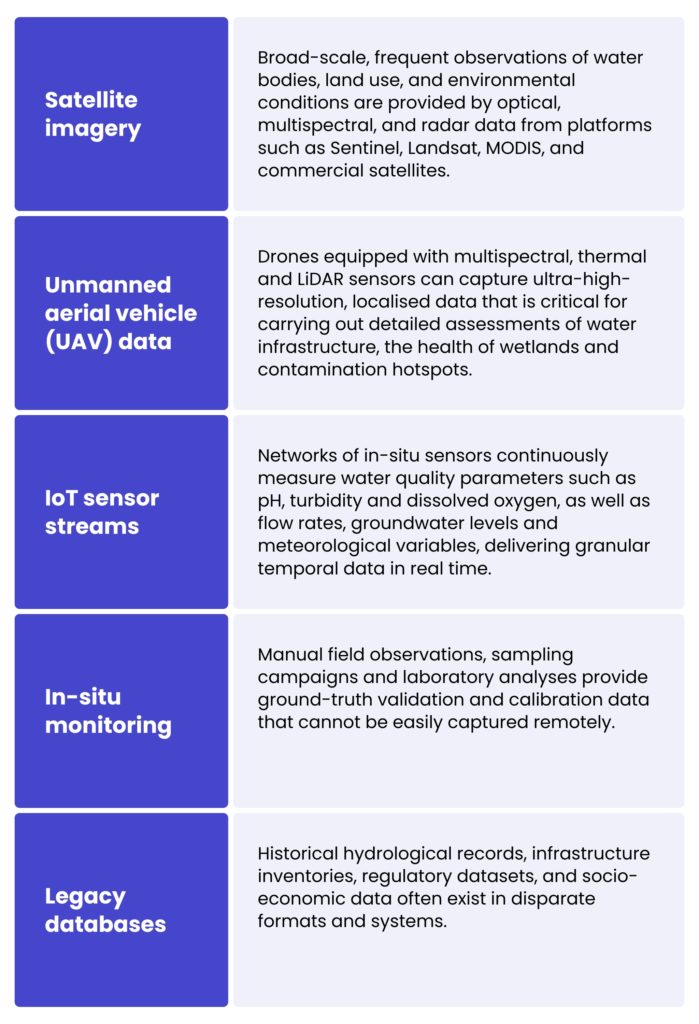
Harmonising these datasets involves aligning data with varying resolutions, formats and levels of accuracy in terms of both space and time. Techniques such as data normalisation, coordinate reference system transformation, temporal interpolation and metadata standardisation can ensure compatibility. Advanced ETL pipelines and data fusion algorithms combine remote sensing imagery, sensor data and field observations to create enriched, multidimensional datasets that capture the full complexity of water systems.
الاستفادة من المعايير المفتوحة لتبادل البيانات بسلاسة
يُعد الالتزام بالمعايير الجيومكانية المفتوحة، كما تحددها منظمات مثل الاتحاد المفتوح للبيانات الجيومكانية (OGC)، أمراً أساسياً لتحقيق قابلية التشغيل البيني. وتشمل المعايير الرئيسية ما يلي:
- خدمة الخرائط عبر الويب (WMS) – يتيح التسليم الموحد لصور الخرائط المرجعية جغرافيًا عبر الإنترنت، مما يسمح للمستخدمين بتصور طبقات البيانات المكانية من مصادر متعددة بسلاسة.
- خدمة ميزات الويب (WFS) – Facilitates the querying and retrieval of vector spatial data (points, lines and polygons) in interoperable formats such as GML or GeoJSON, supporting the editing and analysis of dynamic data.
- خدمة مراقبة المستشعرات (SOS) – يوفر وصولًا موحدًا إلى تدفقات بيانات المستشعرات في الوقت الفعلي والمؤرشفة، وهو أمر ضروري لدمج قياسات إنترنت الأشياء في منصات نظم المعلومات الجغرافية.
- خدمات الكتالوج للويب (CSW) – يدعم اكتشاف وإدارة البيانات الوصفية لمجموعات البيانات المكانية عبر المؤسسات.
بناء بنى تحتية للبيانات المكانية على مستوى المؤسسات
To implement advanced data integration and interoperability on a large scale, organisations are investing in spatial data infrastructures. These comprehensive frameworks encompass data repositories, processing capabilities, compliance with standards and user access mechanisms.
المكونات الرئيسية للبنية التحتية للبيانات المكانية (SDI) على مستوى المؤسسات لإدارة الموارد المائية:
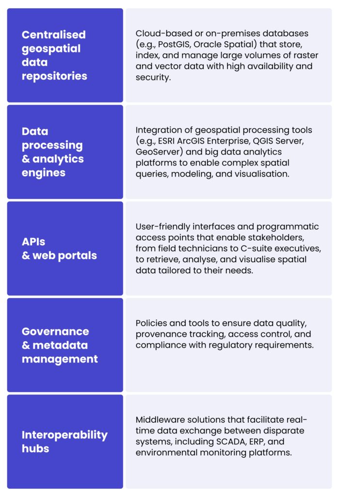
Water resource businesses can optimise workflows, enhance data-driven decision-making processes and encourage cross-sector collaboration by establishing robust SDIs. This is crucial for integrated water management and conservation.
محاكاة هيدروديناميكية متقدمة مدفوعة بنظم المعلومات الجغرافية وتتبع التلوث في الموارد المائية
Advanced, GIS-driven hydrodynamic simulations are essential for the effective management and protection of water resources. These tools combine geospatial data with models that simulate water movement, helping researchers and planners understand how water flows through rivers, lakes, and urban drainage systems. When linked with detailed spatial information, such as terrain elevation, land cover, and soil types, the simulations can predict areas at risk of flooding or erosion.
In addition to modelling water flow, GIS technologies are used to track pollution in bodies of water. These technologies can identify sources of contamination, monitor the spread of pollutants and evaluate changes in water quality over time. This is particularly useful for mitigating the impact of human activities, such as agricultural practices or industrial discharges, on freshwater ecosystems. Armed with this information, decision-makers can develop more targeted and timely strategies for controlling pollution and protecting water ecosystems.
تطبيق ميداني وحالة استخدام عملية
لأحد عملائنا، MicroBubbles GmbH، شركة ألمانية للبحث والتطوير مدعومة من SPRIND وتركز علىالقضاء على التلوث بالبلاستيك الدقيق، قمنا بتطوير حل جيومكاني متقدم لدعم مهمتهم البيئية.
Their main challenge was identifying, analysing, and predicting microplastic distribution in water bodies across Germany to guide the deployment of their cleanup technologies. Our role involved comprehensive technology consulting and system engineering, starting with the creation of منصتان نموذجيتان، أحدها باستخدام تقنية ESRI حزمة تقنية وأخرى مبنية على أدوات نظم المعلومات الجغرافية (GIS) مفتوحة المصدر. وقد جرى تقييمهما من حيث الأداء التقني والتكلفة وقابلية التوسع، وقُدّمت النتائج في تقرير توصيات مفصّل.
We conducted in-depth data collection, reviewing scientific studies and environmental records to compile datasets on microplastic concentrations, land use, wastewater infrastructure, and other relevant parameters. This data was integrated into an interactive map-based system that visualises contamination hotspots and environmental factors, hosted on Microsoft Azure لقابلية التوسع والأمان.
باستخدام ArcGIS Pro, we enabled MicroBubbles to perform sophisticated spatial analysis to identify current pollution clusters and potential future risk zones. The analytical outputs were summarised in detailed reports that support strategic decisions and stakeholder communication. Looking ahead, we are enhancing the system with additional datasets and machine learning models to predict future microplastic hotspots.
This collaboration showcases the vital role of GIS and remote sensing in addressing complex environmental issues like microplastic pollution and advancing sustainable water resource conservation.
الدور عليك
Thanks to modern geospatial tools, water systems can now be mapped with unprecedented precision, hydrodynamic behaviour simulated and pollution monitored in real time. This enables more proactive and data-driven decision-making. We help organisations gain deeper insights into water-related issues and implement sustainable, targeted solutions by combining high-resolution spatial data with advanced analytics.
إذا كانت لديك أي أسئلة أو ترغب في مناقشة فرص التعاون، فيرجى استخدام النموذج أدناه للتواصل مع خبرائنا.
Geographic information systems (GIS) and remote sensing provide precise, real-time spatial data, enabling proactive monitoring, modelling and decision-making. These technologies help to track water bodies, detect anomalies, assess flood and drought risks, and support the development of sustainable water allocation and conservation strategies.
Remote sensing involves the use of satellite and aerial imagery, including multispectral, hyperspectral and radar data, to monitor changes in water bodies, watersheds and land use. This enables the detection of both long-term trends and immediate anomalies, which are crucial for timely intervention.
GeoAI combines artificial intelligence and machine learning with geospatial data to automate the extraction of features, improve the mapping of water bodies, detect environmental changes and forecast risks such as droughts and floods. This increases accuracy, scalability and predictive capabilities.
Integrating satellite imagery, drone data, Internet of Things (IoT) sensor streams, in-situ monitoring and historical records provides a comprehensive view of water systems. This integration enables advanced analytics, enhances decision-making processes, and guarantees interoperability between platforms and stakeholders.
These simulations model the flow of water in rivers, lakes and drainage systems. This helps to identify flood-prone areas and track the spread of pollution. These insights can be used by decision-makers to prevent disasters, protect ecosystems and plan infrastructure more effectively.


arrow_circle_rightاتصل بنا
لنتواصل للتحقق من كيفية دعم خبرائنا لمشروعك

arrow_circle_right مقالاتنا