SIG et télédétection pour une meilleure gestion et conservation des ressources en eau


Water is an increasingly scarce and strategic resource that is under unprecedented pressure due to rapid population growth, expanding industrial activities, intensified agriculture and the accelerating impacts of climate change. The global water crisis manifests in various interconnected ways, such as reduced freshwater availability, altered precipitation patterns, groundwater depletion, and degradation of vital aquatic ecosystems.
Malgré les progrès récents, des lacunes substantielles subsistent dans la gestion des eaux usées. Dans l'un des rapports nous pouvons constater qu'en 2022, seulement 60% des eaux usées totales étaient traitées en toute sécurité à l'échelle mondiale. Cela laissait une estimation de 40%, equivalent to tens of billions of cubic metres annually, potentially contaminating rivers, soils, and groundwater. Notably, the number of countries able to report on safely treated wastewater increased by almost threefold between 2015 and 2022, yet comprehensive data still covers just 42% de la population mondiale. Ces lacunes persistantes soulignent le besoin urgent de solutions innovantes pour résoudre ce problème pressant.
The complex and evolving challenges facing water resources require more than traditional, reactive and fragmented approaches to management. The urgency of the situation demands integrated, predictive and real-time decision-making frameworks that can anticipate risks and optimise interventions. Central to this transformation is the adoption of spatial intelligence as a core capability.
Cet article examine comment les systèmes d'information géographique, la télédétection et les technologies de GeoAI offrent une boîte à outils robuste et complète pour la surveillance dynamique, la modélisation et la gestion des systèmes hydriques.
Impact des SIG et de la télédétection sur la gestion des ressources en eau
En facilitant le passage de mesures périodiques sur site à des stratégies proactives guidées par les données, les technologies SIG et de télédétection permettent aux organisations et aux décideurs politiques d'aborder plus efficacement la complexité croissante des problématiques liées à l'eau.
Télédétection provides a wide variety of satellite and aerial data, such as multispectral, hyperspectral and radar imagery, which enables the timely monitoring of water bodies, watersheds and changes in land use. This breadth of data is essential for tracking dynamic hydrological systems, detecting anomalies and analysing long-term environmental trends. When integrated within a unified Framework SIG aux côtés de divers jeux de données, tels que les sorties de capteurs IoT et les observations de terrain, la télédétection permet une analyse spatiale sophistiquée.
Découvrez nos offres géospatiales !
En savoir plus
The technologies further enhance climate resilience by enabling detailed climate risk assessments, modelling future scenarios, and developing adaptive strategies for water allocation, infrastructure planning, and ecosystem conservation. Operationally, the integration of GIS, remote sensing, IoT, and cloud platforms enables real-time monitoring of water systems, allowing for rapid detection of leaks, contamination, and other issues. GIS-driven analysis also improves infrastructure planning and maintenance, reducing both costs and environmental impact. Centralised spatial data fosters collaboration, streamlines implementation, and strengthens oversight.
Utiliser le GeoAI pour améliorer l'analyse des ressources en eau et l'atténuation des risques
l'intégration deGeoAI et apprentissage automatique techniques with GIS and remote sensing data is changing water resources management by enabling automated, accurate, and scalable analysis of complex spatial-temporal datasets. These advanced computational methods enhance the ability to extract meaningful information, predict future conditions, and detect anomalies critical for effective water conservation and operational decision-making.
Extraction automatisée de caractéristiques
Traditional manual mapping of water bodies, wetlands, and other hydrological features is labour-intensive, time-consuming, and prone to human error. Deep learning models, particularly convolutional neural networks (CNNs), have demonstrated exceptional capability in accurately delineating water bodies and wetlands at high spatial and temporal resolutions.
- Indices spectraux pour la surveillance des masses d'eau – Les indices spectraux sont des outils largement utilisés pour la surveillance des masses d'eau, en accentuant les caractéristiques propres à l'eau dans l'imagerie satellitaire grâce à des combinaisons mathématiques de bandes spectrales. Des indices courants tels queNDWI, MNDWI, et AWEI are valued for their computational efficiency, simplicity, and compatibility with historical datasets. They enable rapid, large-scale assessments of water extent without the need for training data. However, their effectiveness can be limited in complex environments, where shadows, built-up areas, or turbid water may confuse classification. Additionally, they are sensitive to atmospheric conditions and often require manual thresholding. Despite these limitations, spectral indices remain essential tools and are increasingly integrated with deep learning methods to improve precision and adaptability in water mapping.
- Délimitation des plans d'eau – Deep learning algorithms process multi-spectral satellite imagery (for example: Sentinel-2, Landsat 8) to distinguish water pixels from other land cover types with high precision. This automated delineation supports continuous monitoring of lakes, rivers, reservoirs, and ephemeral water bodies, enabling timely assessment of seasonal and long-term changes.
- Cartographie des zones humides – These are critical ecosystems that require precise mapping for conservation. GeoAI models trained on labelled datasets can classify wetland types based on spectral, textural, and contextual (spatial) information, facilitating large-scale wetland inventory and health assessment.
- Détection des changements – By applying recurrent neural networks (e.g. LSTMs) and sequence modelling networks like Transformers to time-series satellite data, automated change detection identifies alterations in water extent, land cover, and vegetation health. This capability is crucial for monitoring drought impacts, urban encroachment, and ecosystem degradation.
Modélisation prédictive
Les modèles de machine learning excellent à exploiter des données environnementales multi-sources et temporelles pour prévoir les phénomènes hydrologiques et les schémas de demande en eau, offrant ainsi un avantage prédictif à la gestion des ressources en eau.
- Prévision des sécheresses – By integrating remote sensing indices (e.g., normalised difference vegetation index, soil moisture active passive data) with meteorological variables, ML models can predict drought onset, severity, and duration with improved lead times. These predictions allow for proactive water allocation and conservation measures.
- Prévision des inondations – Combining rainfall data, topographic information, and historical flood records within ML frameworks facilitates real-time flood forecasting and risk mapping. Advanced models such as gradient boosting machines and deep neural networks capture nonlinear hydrological relationships, improving flood warning accuracy.
- Estimation de la demande en eau – L'analyse prédictive utilisant des données socio-économiques, des variables climatiques et des schémas de consommation historiques permet aux services publics de prévoir la demande en eau de manière dynamique. Cela permet d'optimiser la planification de l'approvisionnement, de réduire le gaspillage et de garantir la fiabilité.
Détection d'anomalies
La détection d'anomalies dans les systèmes d'eau est essentielle pour identifier les activités non autorisées, les incidents de pollution et les dysfonctionnements d'infrastructure qui menacent la sécurité et la qualité de l'eau.
- Prélèvements d'eau illégaux – AI-driven spatial analytics analyse remote sensing imagery and sensor network data to detect unusual water extraction patterns inconsistent with permitted usage. For example, sudden drops in reservoir levels or groundwater tables can be flagged for investigation.
- Identification des événements de pollution – Machine learning models trained on spectral signatures of contaminants can detect pollution plumes in water bodies from hyperspectral and multispectral imagery. Early detection of chemical spills, algal blooms, or sediment influx allows for rapid response and mitigation.
- Défaillances des infrastructures – Les algorithmes de détection d'anomalies appliqués aux flux de données des capteurs (pression, débits, qualité de l'eau) identifient les fuites, les ruptures de canalisations et les dysfonctionnements des usines de traitement en quasi-temps réel. Cela favorise la maintenance prédictive et minimise les interruptions de service.
Intégration avancée des données et interopérabilité
Effective water resources management requires the ability to integrate, harmonise and analyse diverse spatial and temporal datasets from multiple sources. Advanced data integration and interoperability frameworks enable businesses to combine disparate data streams – ranging from satellite imagery to ground-based sensors – into coherent, actionable intelligence.
Harmonisation de jeux de données multi-sources
Les données sur les ressources en eau sont intrinsèquement multidimensionnelles et multisources, englobant :
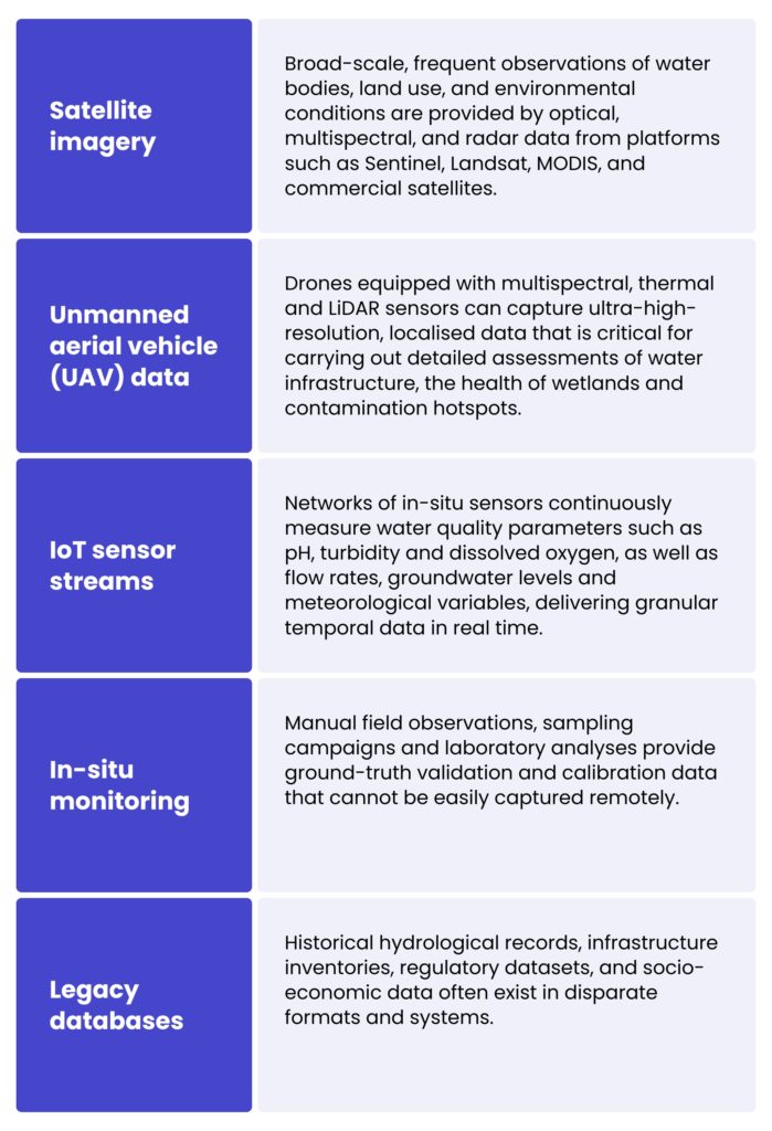
Harmonising these datasets involves aligning data with varying resolutions, formats and levels of accuracy in terms of both space and time. Techniques such as data normalisation, coordinate reference system transformation, temporal interpolation and metadata standardisation can ensure compatibility. Advanced ETL pipelines and data fusion algorithms combine remote sensing imagery, sensor data and field observations to create enriched, multidimensional datasets that capture the full complexity of water systems.
Tirer parti des normes ouvertes pour un échange de données transparent
Le respect des normes géospatiales ouvertes, telles que définies par des organisations comme l'Open Geospatial Consortium (OGC), est fondamental pour l'interopérabilité. Les principales normes incluent :
- Un service de cartographie web (WMS) – Permet la diffusion standardisée d'images cartographiques géoréférencées sur internet, offrant aux utilisateurs la possibilité de visualiser de manière fluide des couches de données spatiales provenant de sources multiples.
- Web Feature Service (WFS) – Facilite l'interrogation et la récupération de données spatiales vectorielles (points, lignes et polygones) dans des formats interopérables tels que GML ou GeoJSON, en prenant en charge l'édition et l'analyse de données dynamiques.
- Service d'observation par capteurs (SOS) – Fournit un accès standardisé aux flux de données de capteurs en temps réel et archivés, ce qui est essentiel pour intégrer les mesures IoT dans les plateformes SIG.
- Catalogue Services for the Web (CSW) – Prend en charge la découverte et la gestion des métadonnées pour les jeux de données spatiales à travers les organisations.
Construire des infrastructures de données spatiales à l'échelle de l'entreprise
To implement advanced data integration and interoperability on a large scale, organisations are investing in spatial data infrastructures. These comprehensive frameworks encompass data repositories, processing capabilities, compliance with standards and user access mechanisms.
Composants clés d'une IDS à l'échelle de l'entreprise pour la gestion des ressources en eau :
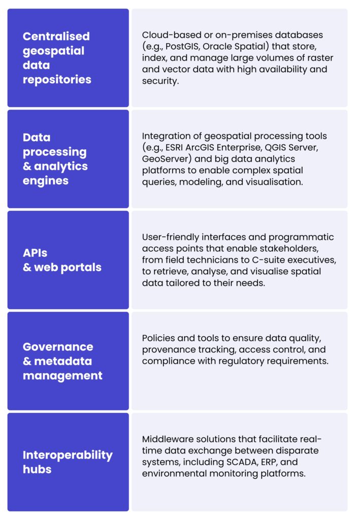
Les entreprises du secteur des ressources en eau peuvent optimiser leurs flux de travail, améliorer leurs processus de prise de décision fondés sur les données et encourager la collaboration intersectorielle en établissant des SDI robustes. Cela est crucial pour une gestion intégrée de l'eau et la conservation.
Simulation hydrodynamique avancée pilotée par SIG et suivi de la pollution dans les ressources en eau
Advanced, GIS-driven hydrodynamic simulations are essential for the effective management and protection of water resources. These tools combine geospatial data with models that simulate water movement, helping researchers and planners understand how water flows through rivers, lakes, and urban drainage systems. When linked with detailed spatial information, such as terrain elevation, land cover, and soil types, the simulations can predict areas at risk of flooding or erosion.
In addition to modelling water flow, GIS technologies are used to track pollution in bodies of water. These technologies can identify sources of contamination, monitor the spread of pollutants and evaluate changes in water quality over time. This is particularly useful for mitigating the impact of human activities, such as agricultural practices or industrial discharges, on freshwater ecosystems. Armed with this information, decision-makers can develop more targeted and timely strategies for controlling pollution and protecting water ecosystems.
Application sur le terrain et cas d'usage pratique
Pour l'un de nos clients, MicroBubbles GmbH, une entreprise allemande de R&D soutenue par SPRIND et spécialisée danséliminer la pollution par les microplastiques, nous avons développé une solution géospatiale avancée pour soutenir leur mission environnementale.
Their main challenge was identifying, analysing, and predicting microplastic distribution in water bodies across Germany to guide the deployment of their cleanup technologies. Our role involved comprehensive technology consulting and system engineering, starting with the creation of deux plateformes prototypes, l'un utilisant le technologie ESRI stack et une autre reposant sur des outils SIG open source. Celles-ci ont été évaluées selon leurs performances techniques, leur coût et leur évolutivité, et les conclusions ont été présentées dans un rapport de recommandation détaillé.
We conducted in-depth data collection, reviewing scientific studies and environmental records to compile datasets on microplastic concentrations, land use, wastewater infrastructure, and other relevant parameters. This data was integrated into an interactive map-based system that visualises contamination hotspots and environmental factors, hosted on Microsoft Azure pour l'évolutivité et la sécurité.
Utilisation ArcGIS Pro, we enabled MicroBubbles to perform sophisticated spatial analysis to identify current pollution clusters and potential future risk zones. The analytical outputs were summarised in detailed reports that support strategic decisions and stakeholder communication. Looking ahead, we are enhancing the system with additional datasets and machine learning models to predict future microplastic hotspots.
Cette collaboration illustre le rôle essentiel des SIG et de la télédétection dans la résolution de problématiques environnementales complexes telles que la pollution par les microplastiques, ainsi que dans la promotion d'une conservation durable des ressources en eau.
À vous de jouer
Thanks to modern geospatial tools, water systems can now be mapped with unprecedented precision, hydrodynamic behaviour simulated and pollution monitored in real time. This enables more proactive and data-driven decision-making. We help organisations gain deeper insights into water-related issues and implement sustainable, targeted solutions by combining high-resolution spatial data with advanced analytics.
Si vous avez des questions ou souhaitez discuter d'opportunités de collaboration, veuillez utiliser le formulaire ci-dessous pour contacter nos experts.
Geographic information systems (GIS) and remote sensing provide precise, real-time spatial data, enabling proactive monitoring, modelling and decision-making. These technologies help to track water bodies, detect anomalies, assess flood and drought risks, and support the development of sustainable water allocation and conservation strategies.
Remote sensing involves the use of satellite and aerial imagery, including multispectral, hyperspectral and radar data, to monitor changes in water bodies, watersheds and land use. This enables the detection of both long-term trends and immediate anomalies, which are crucial for timely intervention.
GeoAI combines artificial intelligence and machine learning with geospatial data to automate the extraction of features, improve the mapping of water bodies, detect environmental changes and forecast risks such as droughts and floods. This increases accuracy, scalability and predictive capabilities.
Integrating satellite imagery, drone data, Internet of Things (IoT) sensor streams, in-situ monitoring and historical records provides a comprehensive view of water systems. This integration enables advanced analytics, enhances decision-making processes, and guarantees interoperability between platforms and stakeholders.
These simulations model the flow of water in rivers, lakes and drainage systems. This helps to identify flood-prone areas and track the spread of pollution. These insights can be used by decision-makers to prevent disasters, protect ecosystems and plan infrastructure more effectively.


arrow_circle_rightnous contacter
Contactez-nous pour découvrir comment nos experts peuvent soutenir votre projet

arrow_circle_right Nos articles