سد الفجوة الهندسية في استخراج بصمة المباني: نظرتنا الأولى إلى HiSup


Accurately extracting building footprints from satellite or aerial imagery has long posed a challenge in the geospatial field, particularly when it comes to preserving geometric precision. Traditional methods often prioritise speed over detail, resulting in outputs that do not meet the accuracy requirements of urban planning, infrastructure development and environmental monitoring. This is where HiSup comes in – it is a promising new method aimed at closing the geometry gap in building footprint extraction.
في هذا المقال، نلقي نظرة أولى على HiSup، مستكشفين كيف يحسّن دقة المضلعات ويمثل خطوة كبيرة إلى الأمام في إنشاء مجموعات بيانات جغرافية مكانية عالية الجودة.
من أقنعة البيانات النقطية إلى المتجهات الجاهزة للأعمال
في إحدى مقالاتنا السابقة حول التعرف الآلي على المباني, we demonstrated a high-performing segmentation pipeline. Yet as soon as we shared the results with insurers, emergency-response analysts and cadastral specialists, one concern surfaced immediately:
المضلعات لا تتوافق مع الجدران.
These teams work with vector footprints every day that must snap to parcel boundaries, setback lines, or flood-risk buffers. Classical post-processing techniques such as Douglas–Peucker simplification, marching squares and hand-tuned regularisation could not bridge the gap between our smooth raster masks and the crisp geometry required. The root cause is the well-known mask-reversibility problem: convolutional networks learn region consistency first and boundary precision second. This means that information which would enable perfect back-conversion to polygons is lost during training.
كانت هناك حاجة إلى تغيير جذري.
HiSup: إشراف هرمي للتعلّم الواعي بالشكل
تم تقديم نموذج HiSup (الإشراف الهرمي) من قبل Bowen Xu وJiakun Xu وNan Xue وGui-Song Xia في مجلة ISPRS للتصوير المساحي والاستشعار عن بعد (2023).
لماذا لا تزال الدقة على مستوى المضلع مهمة
Although high-resolution satellite imagery has made the semantic segmentation of buildings relatively routine, most geospatial workflows, from cadastral updates to insurance risk models, consume vector polygons rather than raster masks. Conventional pipelines therefore first segment and then vectorise, typically using Douglas–Peucker or marching squares heuristics. This approach has two drawbacks:
- الفجوة في الأداء بين Mask وpolygon
تحقق الأقنعة عالية الأداء قيمة IoU مرتفعة، لكن بعد تحويلها إلى متجهات، ينخفض متوسط دقتها بشكل ملحوظ، على سبيل المثال 79 % → 67 % في معيار AICrowd.
- أقنعة لا رجعة فيها
تُفقد تفاصيل الحدود الدقيقة في الرؤوس الدلالية التي تُحسّن فقط لاتساق المناطق، مما يجعل التحويل العكسي الأمين إلى مضلعات أمرًا مستحيلًا.
نقدّم HiSup للكشف الدقيق عن البصمة
تعالج الإشراف الهرمي عنق الزجاجة المتعلق بـ "قابلية عكس القناع" من خلال تدريب ثلاثة مستويات هندسية في وقت واحد:
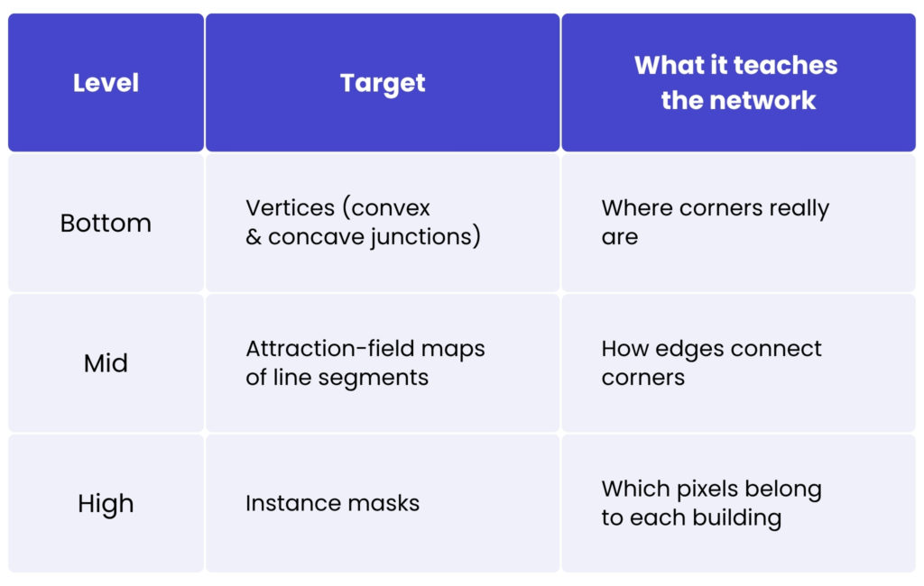
A lightweight, cross-level interaction module incorporates the mid-level attraction field into both the vertex and mask heads, reinforced by an efficient channel-attention mechanism. The result is masks that already ‘know’ where their precise boundaries lie, making the final polygonisation process trivial – boundary pixels are simply attracted to the nearest predicted vertex (MaV-Attr).
مكاسب قابلة للقياس الكمي
في مجموعة التحقق الخاصة بتحدي رسم الخرائط على AICrowd:
- الدقة (COCO 0.5-0.95): 79.4 % – بزيادة +12.4 نقطة مئوية عن Frame-Field و+5.6 نقطة مئوية عن أفضل نموذج سابق مشترك للرؤوس والحواف.
- APboundary: 66.5 % – قفزة بمقدار +16.5 نقطة مئوية تعكس الدقة الحقيقية للأداء.
- تباين PoLiS: 0.726 – الأدنى بين جميع الطرق المنشورة، مما يؤكد الحد الأدنى من تكرار الرؤوس.
- في معيار Inria Aerial Image Labeling عبر المدن، يحقق HiSup نسبة IoU تبلغ 75.5 % ودقة بكسل تبلغ 96.3 %، متجاوزًا جميع الأساليب المضلعية السابقة دون ضبط دقيق خاص بكل مدينة.
الأثر التجاري لخطوط معالجة البيانات الجغرافية المكانية
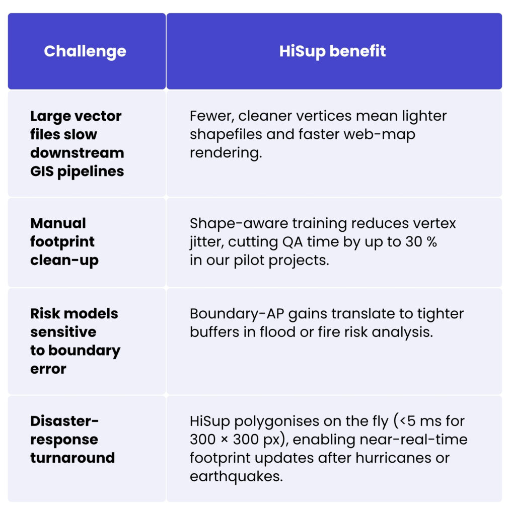
HiSup offers a range of tangible benefits for geospatial data processing workflows. By producing cleaner vectors with fewer vertices, it significantly reduces file sizes, resulting in lower storage requirements and reduced network transfer costs. Its fast post-processing capabilities – achieving speeds under 5 milliseconds on a 300 × 300 tile – eliminate the need for global graph optimisation, thereby streamlining downstream operations. The model also preserves sharp boundary details, which are essential for tasks such as setback analysis, flood-risk mapping and property-tax assessments. HiSup is also highly flexible, being compatible with HRNet and U-ResNet, and having been trained end-to-end using standard BCE and L1 loss functions. This makes it easily adaptable to various deployment environments.
معيارنا الداخلي: نتائج المحاولة الأولى
قمنا بضبط HiSup باستخدام مجموعة بيانات صغيرة لكن عالية الجودة من بصمات أوروبية وأمريكية شمالية متنوعة. والأرقام الأولية أدناه مشجعة بالفعل.
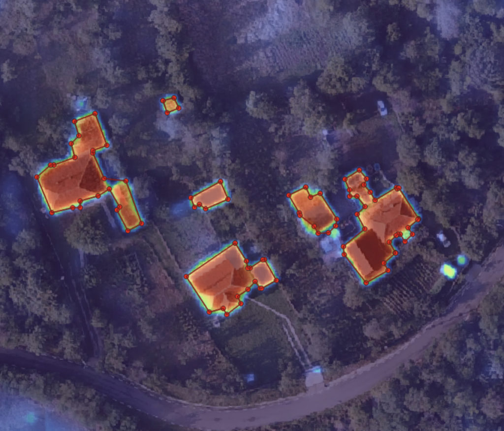
قناع الاحتمال الدلالي مقابل تراكب مضلع HiSup
دقة مساحة البصمة
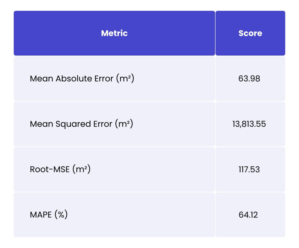
The MAE shows that the error distribution is heavy-tailed: over-prediction occurs on closely spaced terraced houses. The MSE metric amplifies the same outliers. Once we fine-tune for densely spaced footprints, we expect this to drop sharply. The RMSE metric, which is equivalent to misplacing a 10.85 m × 10.85 m square, is already workable for parcel-level screening tasks. When examining the mean average percentage error, the small sheds skew the percentage errors.
مقاييس التقسيم التقليدية
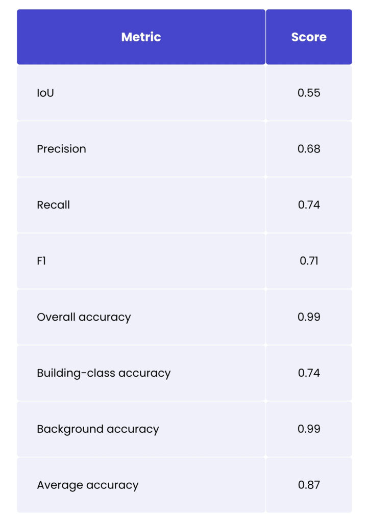
The Polygon IoU is much lower than indicated in the papers, suggesting a significant difference between our area of interest and the training dataset in terms of building appearance. Fine-tuning on regional data should help. Smaller and more irregular structures also contribute to lower scores. The F1-score often exceeds the 0.70 threshold frequently referenced in the context of semi-automated mapping workflows. Overall accuracy is inflated by the dominant background class – see the per-class figures for a more accurate picture. Average accuracy provides a balanced view of both classes, but there is still room for improvement.
مطابقة Polygon عند عتبات متعددة لتداخل Ground Truth
باستخدام هذا التقييم، نريد أن نرى عدد المباني الفردية التي نكتشفها عند عتبات تداخل GT المختلفة.
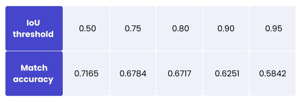
يتداخل ما يقرب من ثلاثة أرباع البصمات مع البيانات المرجعية بنسبة لا تقل عن 50%، وهو بالفعل على قدم المساواة مع الخطوط الأساسية العامة. الانخفاض التدريجي مع 75–80% عتبات التداخل تؤكد أن HiSup يحتفظ بتفاصيل الحدود بشكل أفضل مما تفعله خطوط أنابيب تحويل الأقنعة إلى متجهات. في 90% التداخل، يُبرز التداخل الصارم الحساسية تجاه الملاحق، والأسقف المتراكمة، والأسقف المحجوبة بالأشجار. إشارات الارتفاع هي التالية في خارطة طريقنا. أخيراً، في 95% تتقاطع، ما يقرب من ستة من كل عشرة مضلعات تكاد تكون مطابقة للبكسل تمامًا، مما يوفر أساسًا متينًا للتحديثات العقارية الآلية.
An important caveat is that the model has not yet been fine-tuned for local architectural styles, roof-edge materials, or off-nadir distortions. We expect to see significant improvements once we adapt the final layers to the data distribution of each region.
لماذا يعد هذا مهمًا لأعمالك
متجهات بناء دقيقة وخفيفة الوزن عبر محفظة Spyrosoft
تخلق مخرجات HiSup الدقيقة والمضغوطة لبصمات المباني قيمة تتجاوز بكثير المجال الجغرافي المكاني، مما يولّد تأثيرًا متسلسلًا عبر مجالات متعددة من خبرات Spyrosoft. في خدمات المعلومات الجغرافية المكانية والذكاء الاصطناعي الجغرافي المكاني، على سبيل المثال، تتكامل بصمات HiSup بسلاسة مع سلاسل الأدوات الحالية، مما يتيح تطبيقات مثل لوحات معلومات اكتشاف التغييرات ونماذج الضرائب على مستوى قطع الأراضي. في حلنا الذكاء الاصطناعي وتعلم الآلة عمليًا، تُسهّل هذه المتجهات المدركة للشكل تطوير أنظمة شاملة لمراقبة الأصول وخطوط معالجة متطورة لتقييم المخاطر.
من منظور النشر، يتلاءم HiSup بشكل طبيعي مع عرضنا في مجال السحابة ومنصات البيانات. It can be run efficiently on scalable Kubernetes clusters or serverless GPU infrastructure, with outputs streamed directly into cloud-native data and business intelligence ecosystems for real-time spatial analytics. HiSup delivers clean, ready-to-use building polygons that require no additional post-processing across various industry verticals, including insurers (within our مجال الخدمات المالية)، فرق الاستجابة للطوارئ (الدفاع والفضاء)، ومشغلو المدن الذكية (الصناعة 4.0ومقدمي الخدمات، مما يسرّع تحقيق القيمة في سير العمل الحيوي.
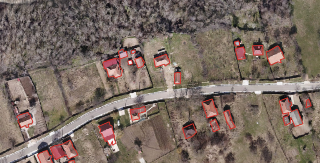
تكبير المضلعات المتوقعة
الخاتمة
HiSup integrates seamlessly into our Geospatial Services and AI practice, supporting everything from satellite-image tiling to vector-tile delivery within domain-specific data pipelines. Its mature model lifecycle management, which spans scalable data labelling, experiment tracking, on-device quantisation and MLOps, ensures reliability and performance, whether it is deployed in the cloud or on-premises.
By combining HiSup with our expertise in developing end-to-end GeoAI solutions, we help our clients to speed up innovation in geospatial intelligence. So, if your project requires custom integration, our cross-functional teams can take you from prototype to production while meeting industry-specific compliance standards. Fill in the form below and let’s connect!
الأسئلة الشائعة: HiSup
Traditional segmentation models produce raster masks that often look visually correct but fail to align precisely with real building walls once converted to polygons. This “mask reversibility” problem results in geometry loss during training. HiSup addresses this by learning boundary-aware representations, enabling more accurate and business-ready polygon outputs.
Conventional workflows rely on post-processing techniques such as Douglas–Peucker simplification or marching squares. While these methods can simplify geometry, they cannot recover boundary details that were never learned by the model. As a result, vectorised polygons often show reduced precision compared to the original masks.
يستخدم HiSup الإشراف الهرمي لتدريب ثلاثة مستويات هندسية في وقت واحد:
– التنبؤ بالأقنعة على مستوى البكسل
– حقول الجذب متوسطة المستوى
– كشف المضلعات على مستوى القمة
A cross-level interaction module ensures that mask predictions are aware of their precise boundaries. During polygonisation, boundary pixels are simply attracted to the nearest predicted vertex, making the conversion process both accurate and efficient.
Many professional workflows (including cadastral updates, flood-risk analysis, insurance modelling and property taxation) operate on vector polygons, not raster masks. Precise boundaries ensure alignment with parcel data, zoning rules and infrastructure layers, directly affecting decision-making quality and regulatory compliance.
Yes. HiSup is lightweight and flexible. It integrates with architectures such as HRNet and U-ResNet and can be trained end-to-end using standard BCE and L1 loss functions. This makes it suitable for various deployment scenarios, including cloud-native and on-premises environments.


arrow_circle_rightاتصل بنا
لنستكشف كيف يمكننا دعم مشروعك

arrow_circle_right مقالاتنا