إدارة المخاطر الاستباقية في الخدمات اللوجستية باستخدام التحليلات الجغرافية المكانية


في سلسلة توريد مترابطة عالميًا، العمليات اللوجستية face an unprecedented range of risks. As companies strive to increase resilience and ensure uninterrupted service, reactive risk management strategies are no longer sufficient. To stay competitive and mitigate losses, logistics leaders must shift toward a proactive, data-driven approach to identifying and addressing vulnerabilities before they escalate.
في هذا السياق، يمكن للتحليلات الجيومكانية أن تلعب دورًا محوريًا. من خلال دمج ذكاء الموقع with real-time operational data, geospatial analytics provides actionable insights into risk exposure across the entire logistics network. From tracking fleet movement in real-time to forecasting delays caused by natural disasters or urban congestion, geospatial tools enable organisations to anticipate disruptions, optimise decision-making, and safeguard supply chain continuity.
في هذه المقالة، سنستكشف كيف يمكن للتحليلات الجغرافية المكانية دعم فرق الخدمات اللوجستية لإدارة المخاطر بشكل استباقي.
أهمية تقييم المخاطر البيئية
An environmental risk assessment is a critical component of modern logistics and supply chain management, especially given the increasing frequency and severity of climate-related disruptions. Transport networks, distribution centres, and storage facilities are becoming increasingly vulnerable to natural disasters such as floods, wildfires, hurricanes, and extreme weather conditions. These events can cause significant operational disruptions, endanger safety, and lead to increased costs.
التحديد والتقييم الاستباقي لهذه المخاطر البيئية enables organisations to strengthen their operational resilience by implementing mitigation strategies before any disruption occurs. This may involve selecting alternative transport corridors, redesigning delivery schedules or reconfiguring warehouse locations to avoid high-risk areas. Furthermore, an environmental risk assessment helps organisations comply with regulatory requirements, such as climate disclosure frameworks and sustainability standards, while also aligning with broader بيئي, اجتماعي و الحوكمة أهداف (ESG).
From a financial standpoint, assessing environmental risk reduces exposure to insurance claims, liability and reputational damage by enabling data-driven, informed decision-making. As environmental volatility becomes a defining challenge in global logistics, integrating risk assessment into strategic and operational planning is essential for maintaining continuity, protecting assets, and ensuring long-term competitiveness.
اطلع على حلولنا الجغرافية المكانية لقطاع الخدمات اللوجستية
عرض المزيد
الدور الذي تلعبه التحليلات الجغرافية المكانية في إدارة المخاطر
Geospatial analytics are enhancing the risk management capabilities of the logistics sector by incorporating a spatial dimension into the identification, analysis, and mitigation of potential threats. At its core, it enables businesses to understand where risks lie, mapping the spatial distribution of vulnerabilities, disruptions and dependencies across the supply chain. With geolocation context businesses are able to identify patterns, model impact zones and execute timely, localised responses.
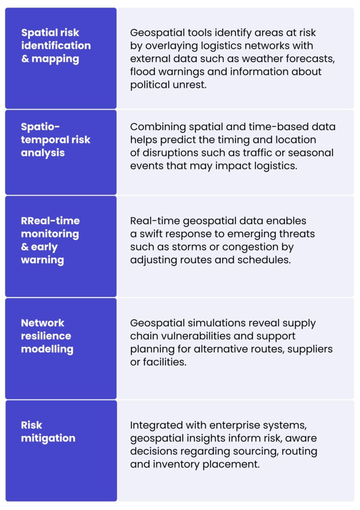
الفوائد والتطبيقات الرئيسية للتحليلات الجغرافية المكانية في الخدمات اللوجستية
- تحسين المسارات – يساعد تحليل البيانات الجغرافية في تحديد مسارات النقل الأكثر كفاءة والأقل مخاطرة، مما يحسّن أوقات التسليم ويقلل استهلاك الوقود.
- تخطيط مواقع المرافق – Geospatial analytics assists in selecting optimal locations for warehouses and distribution centres by evaluating factors such as proximity to markets, transport networks and environmental risks.
- Iإدارة المخزون – يدعم التحليل المكاني استراتيجيات أفضل لتوزيع المخزون ونقله من خلال توفير رؤى حول أنماط الطلب الإقليمية والاضطرابات المحتملة في سلسلة التوريد.
- المراقبة في الوقت الفعلي – يتيح تنفيذ الأدوات الجغرافية المكانية التتبع في الوقت الفعلي للأصول والشحنات، مما يعزز الرؤية والاستجابة للأحداث غير المتوقعة.
- التعافي من الكوارث والاستجابة – في حالات الكوارث الطبيعية، تسهّل التحليلات الجغرافية المكانية التقييم والاستجابة السريعين من خلال تحديد المناطق المتضررة وتحسين لوجستيات الإغاثة.
- الامتثال للقيود الحكومية أو المحلية أو قيود الولاية – تضمن التحليلات الجغرافية توافق العمليات مع اللوائح التنظيمية من خلال مطابقة المسارات والمرافق والأنشطة مع الحدود القانونية والبيئية.
التقنيات التي تُمكّن من إدارة المخاطر الاستباقية في الخدمات اللوجستية
جمع البيانات والمعالجة المسبقة
Geospatial analytics relies on vast and diverse data sources like GPS signals, IoT sensors, satellite imagery, weather feeds, traffic data, and even social media. These sources often vary in format, structure, and frequency, creating significant challenges in harmonisation. Preprocessing involves cleansing noisy data, correcting spatial inaccuracies, converting timestamps, and integrating structured (e.g., tabular delivery data) and unstructured inputs (e.g., image or textual alerts). Robust ETL (Extract, Transform, Load) pipelines and geospatial data wrangling techniques are essential for ensuring reliable downstream analytics.
تنسيقات ومعايير البيانات الجغرافية المكانية
للحفاظ على قابلية التشغيل البيني والاتساق عبر الأنظمة، يجب أن تتوافق البيانات الجغرافية المكانية مع التنسيقات والمعايير المعترف بها:
- الصيغ المتجهية مثل KML وMVT وGeoJSON وملفات الشكل (shapefiles) تمثل معالم مثل الطرق أو مواقع المستودعات أو مناطق التوصيل بنقاط وخطوط ومضلعات.
- الصيغ النقطية تُستخدم لصور الأقمار الصناعية أو خرائط الطقس أو نماذج الارتفاعات، وتمثل البيانات كشبكات بكسل (مثل GeoTIFF).
- المعايير التي تحددها منظمات مثل الاتحاد المفتوح للمعلومات الجغرافية المكانية (OGC) تضمن تبادل البيانات بسلاسة بين الأنظمة.
Choosing the right format is crucial and depending on the type of analysis, raster is typically used for environmental layers, while vector is preferred for tasks like routing or zoning. However, depending on the use case, data may need to be converted between formats, for example, extracting vector features from raster imagery or rasterising vector data for spatial modelling.
تقنيات النمذجة
تقع تقنيات النمذجة المتقدمة في صميم التنبؤ بالمخاطر ومحاكاة السيناريوهات:
- التجميع المكاني (على سبيل المثال، DBSCAN) يكتشف النقاط الساخنة للحوادث المتكررة مثل سرقات التوصيل أو التأخيرات.
- الزماني المكاني يساعد التحليل في تحديد الأنماط التي تتطور عبر المكان والزمان، مثل اختناقات المرور خلال ساعات محددة أو مناطق الفيضانات الموسمية.
التعلّم الآلي الجغرافي المكاني، بما في ذلك أساليب مثل kriging (يُستخدم للاستيفاء المكاني) و كشف النقاط الساخنة، يتيح رؤى تنبؤية، على سبيل المثال، تقدير مستويات المخاطر في المناطق غير المراقبة أو التنبؤ بالمكان الذي يُحتمل حدوث اضطرابات فيه تالياً.
التكامل مع أنظمة الخدمات اللوجستية الحالية
لتقديم قيمة تشغيلية حقيقية، يجب أن تتكامل التحليلات الجغرافية المكانية بسلاسة مع منصات الخدمات اللوجستية الأساسية:
- أنظمة إدارة النقل (TMS) لتحسين المسارات وتخطيط الإرسال.
- تخطيط موارد المؤسسات (ERP) لأنظمة المخزون والمشتريات والآثار المترتبة على المخاطر المالية.
- أنظمة إدارة المستودعات (WMS) لعمليات المرافق وتخطيط الطاقة الاستيعابية.
APIs, middleware and spatial databases (e.g. PostGIS and BigQuery GIS) facilitate this integration by enabling a seamless flow of data and providing actionable insights within familiar operational workflows. Furthermore, analytics engines with spatial support, such as Spark combined with Sedona, facilitate the scalable processing of substantial geospatial datasets, thereby augmenting the system’s capacity for complex spatial analysis.
الأمن والخصوصية في استخدام البيانات الجغرافية المكانية
تُعدّ البيانات الجغرافية المكانية، خاصةً عندما تتضمن مواقع الأسطول أو عناوين العملاء أو الأصول الاستراتيجية، بالغة الحساسية. لذا فإن ضمان أمن البيانات والخصوصية أمر بالغ الأهمية:
- يجب فرض ضوابط الوصول والتشفير (عند التخزين وأثناء النقل) وسجلات التدقيق.
- بالنسبة لبيانات الموقع الشخصية القابلة للتعريف، يُعد الامتثال للوائح مثل GDPR أو CCPA أمراً ضرورياً.
- في بيئات التحليلات الموزعة (مثل معماريات السحابة والحوسبة الطرفية)، يتطلب تأمين البيانات عبر عقد متعددة بروتوكولات أمن سيبراني قوية.
يجب على المؤسسات أيضاً وضع سياسات واضحة لحوكمة البيانات لإدارة مجموعات البيانات الجغرافية المكانية بمسؤولية.
التحديات والقيود
Although geospatial analytics shows great potential for improving risk awareness and operational resilience in logistics, there are challenges associated with its implementation. These limitations span technical, organisational and data-related areas and must be carefully addressed to maximise the benefits of location intelligence.
مشكلات توافر البيانات وجودتها
Effective geospatial analysis relies heavily on access to accurate, up-to-date and high-resolution spatial data. However, logistics operations often involve diverse geographies and jurisdictions where consistent data quality cannot be guaranteed.
- مجموعات البيانات المتناثرة أو القديمة في المناطق النائية أو النامية.
- عدم وجود تنسيقات بيانات موحدة عبر الموردين والناقلين والمناطق، مما يعقّد التكامل.
- تفاوت في دقة البيانات، مما قد يشوّه النتائج التحليلية عند دمج الطبقات العالمية والإقليمية والمحلية الدقيقة.
تعقيد تكامل البيانات
لتقديم رؤى قابلة للتنفيذ، يجب أن تدمج التحليلات الجغرافية المكانية البيانات المكانية مع البيانات التشغيلية من أنظمة المؤسسات المختلفة. ومع ذلك:
- غالبًا ما تفتقر مصادر البيانات غير المتجانسة إلى قابلية التشغيل البيني.
- قد لا تدعم أنظمة الخدمات اللوجستية القديمة استيعاب البيانات في الوقت الفعلي أو التنسيقات الجغرافية المكانية (مثل GeoJSON أو shapefiles).
- تعيق بنى تكنولوجيا المعلومات المعزولة التدفق السلس للمعلومات المكانية السياقية عبر الأقسام.
- Geospatial datasets are tied to specific coordinate reference systems (CRSs). With hundreds of horizontal and vertical datums in use, it can be difficult to unify data under a common reference, especially when reference definitions are missing or inconsistent.
تزيد هذه التعقيدات الحاجة إلى خطوط أنابيب بيانات وواجهات برمجة تطبيقات وبرمجيات وسيطة قوية قادرة على توحيد مجموعات البيانات المكانية وغير المكانية.
الخبرة التقنية وقيود الموارد
يتطلب نشر وصيانة حل التحليلات الجغرافية المكانية مهارات متخصصة لا تتوفر دائمًا ضمن فرق الخدمات اللوجستية التقليدية.
- هناك نقص في المتخصصين في نظم المعلومات الجغرافية وعلماء البيانات ذوي الخبرة في النمذجة المكانية ومتخصصي DevOps الملمّين بخطوط معالجة البيانات الجغرافية المكانية.
- يتطلب تفسير المخرجات المكانية معرفة متخصصة لتجنب اتخاذ قرارات مبنية على معلومات خاطئة، على سبيل المثال، الخطأ في تقدير نطاق تأثير منطقة الفيضان.
- تتطلب المعالجة موارد كثيفة، خاصةً في الحسابات المكانية الفورية أو عالية الدقة، وقد تتطلب بنية تحتية متقدمة أو قدرات حوسبة سحابية.
قيود النماذج والأدوات التحليلية
تتضمن تقنيات النمذجة الجغرافية المكانية قيوداً متأصلة معينة:
- قد تنخفض دقة التنبؤ في البيئات المتقلبة أو سريعة التغير (مثل مناطق النزاع، والمناطق ذات أنماط الطقس غير المتوقعة).
- قد تفشل النماذج الثابتة في التقاط التفاعلات الديناميكية مثل سلوك النقل متعدد الوسائط في ظروف الاضطراب.
- النماذج الزمكانية أكثر دقة ولكنها أكثر تعقيدًا بشكل كبير، وتتطلب مجموعات بيانات أكبر ومعايير مضبوطة بدقة ودورات تطوير أطول.
بالإضافة إلى ذلك، إذا كانت البيانات التاريخية تعكس فقط الظروف "الطبيعية" السابقة، فقد ينشأ تحيز في النموذج، مما يجعله أقل فعالية في توقع تهديدات جديدة.
مخاوف الخصوصية والامتثال والأخلاقيات
قد يمثل استخدام البيانات القائمة على الموقع تحديات قانونية وأخلاقية محتملة.
- لوائح مثل GDPR و CCPA تقييد كيفية جمع البيانات الجغرافية المكانية ومعالجتها وتخزينها، خاصة عندما تكون مرتبطة بأفراد أو عمليات حساسة.
- إذا لم يتم الإفصاح عن ذلك بشفافية والحصول على الموافقة، السياج الجغرافي وقد يثير التتبع في الوقت الفعلي مخاوف لدى الموظفين أو المتعاقدين من الباطن أو العملاء.
- البيانات إخفاء الهوية وتقنيات التشفير تضيف طبقات من التعقيد إلى تصميم النظام وضبط الأداء.
By partnering with us, you can make the most of geospatial analytics without encountering the usual obstacles. With our support, you will avoid fragmented data, interoperability issues, skills shortages and compliance risks, setting your organisation up for resilient, insight-driven logistics operations.
خطوط أنابيب تكامل البيانات لخدمات توصيل الطائرات بدون طيار
لأحدعملائنا، a pioneering American company developing drones and systems for e-commerce delivery, we built a new, scalable data platform to support their rapid growth. Their technology integrates with external systems like LAANC (Low Altitude Authorisation and Notification Capability) to plan drone routes based on factors such as population density, weather, and accident risk.
The client’s original solution, based on periodic scripts, was no longer sufficient. To meet evolving needs, we redesigned their data platform to enable real-time and batch processing, data archiving, and future-proof reporting. We ensured a smooth transition by maintaining the legacy system during the build phase and began with a thorough analysis of existing integrations.
The result is a reliable, high-performing platform that integrates seamlessly with external systems, enhances flight planning accuracy, ensures regulatory compliance, and supports the client’s ongoing expansion with minimal downtime.
الخلاصة
As the logistics becomes increasingly complex and prone to risk, reactive strategies are no longer sufficient to ensure operational continuity. Geospatial analytics offers a powerful, proactive approach to risk management, providing location-based insights from real-time and historical data. It enables organisations to respond faster, smarter and more strategically, from optimising routes and mitigating environmental threats to forecasting supply chain disruptions.
كن شريكًا لنا لتحقيق قيمة أعمال مستدامة
If you think that the time is right for your company to become a market leader and corporate geospatial intelligence as a core component of your risk management strategy, fill up the form and contact our experts!


It adds spatial context to risk data. Instead of knowing that a disruption exists, you know where it is, how it relates to your routes, facilities, and inventory, and what is likely to be affected. That context is what allows logistics teams to act before a disruption hits rather than responding after the fact. Applications include route optimisation, facility location planning, real-time shipment tracking, and rapid disaster response.
Environmental threats such as floods, wildfires, and storms can be mapped against logistics networks in real time. When a weather event is forecast, the system can identify which routes and facilities fall within the affected area and model alternatives. Over time, historical data supports longer-term decisions such as moving facilities away from high-risk zones or redesigning supply chain networks to reduce exposure.
The foundation is a combination of GPS feeds, IoT sensors, satellite imagery, weather data, and traffic information. These need to be standardised into common formats and fed into analytics engines capable of spatial processing at scale. Integration with existing systems such as Transport Management Systems, ERP, and Warehouse Management Systems is also necessary for the insights to be actionable.
Data quality is a consistent issue, particularly in remote regions where coverage is sparse or inconsistent across suppliers. Legacy systems often lack support for geospatial formats, making integration technically complex. There is also a shortage of specialists with combined GIS and data engineering skills. On the analytical side, predictive models trained on historical data can underperform in genuinely volatile or novel conditions.
Yes. GDPR and CCPA place restrictions on how location data relating to employees and customers can be collected, stored, and used. Geofencing and tracking practices need to be transparent, and data anonymisation and encryption add complexity to system design. Organisations should build data governance policies and access controls into the architecture from the outset rather than retrofitting them later.
arrow_circle_rightاتصل بنا
لنتواصل للتحقق من كيفية دعم خبرائنا لمشروعك

arrow_circle_right مقالاتنا